River Washburn

Last updated

River Washburn
Washburn-lindley.png
The River Washburn approaching Lindley Wood Reservoir
Location
Country England
Physical characteristics
Source 
  locationWashburn Head
  coordinates 54°3′46″N1°50′50″W / 54.06278°N 1.84722°W / 54.06278; -1.84722 (Source of River Washburn)
  elevation391 m (1,283 ft)
Mouth  
  location
River Wharfe near Pool
  coordinates
53°54′39″N1°39′6″W / 53.91083°N 1.65167°W / 53.91083; -1.65167 (Mouth of River Washburn)
  elevation
49 m (161 ft)
Length26 km (16 mi)
Basin size87.3 km2 (33.7 sq mi) [1]

The River Washburn is a river in Yorkshire, England. It originates high in the Yorkshire Dales and ends where it meets the River Wharfe. It lies within the Nidderdale Area of Outstanding Natural Beauty. [2]

Contents

Name

The earliest recorded form of the river's name was Walkesburn, from the early 12th century. The name is thought to come from an Old English personal name Walc, not otherwise recorded, so means "stream of a man named Walc". [3]

Course

The river's source is at Washburn Head, just south of Stump Cross Caverns. From there it flows southwards via Thruscross Reservoir, Blubberhouses, Fewston Reservoir, Swinsty Reservoir and Lindley Wood Reservoir, before joining the River Wharfe just north-west of Pool-in-Wharfedale near Leathley. [4]

Reservoirs

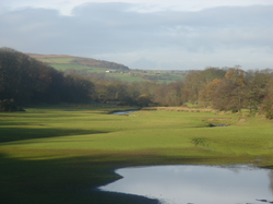
The Washburn has been dammed to a series of four reservoirs, all built to supply water to the city of Leeds. The lower three (Lindley Wood, Swinsty and Fewston) were built at the end of the 19th century, while the fourth, Thruscross, was delayed until the 1960s. [5] Fewston and Swinsty reservoirs have a surface area of around 1.6 square kilometres (0.62 sq mi) and a combined length of 4.1 kilometres (2.5 mi); Thackray Beck and Spinksburn Beck are major tributaries flowing into these reservoirs. [6] Capelshaw Beck is the main tributary flowing into Thruscross reservoir. [2]

Geology

Where the valley has not been flooded to make reservoirs, the sides are V-shaped. The valley floor consists of solid Millstone Grit overlain with till drift. The drainage can be described as slowly permeable and seasonally waterlogged. The bedrock is covered with fine loam over clay soils and some peat soils at higher elevations on the fringe of the moorland. [2] [6] [7]

Geography

The river valley has grassland that is intensively managed for livestock. There are also a range of field sizes, bounded by stonewalls that are often reinforced with post and wire fencing, plus some post and rail fencing. There are very large conifer forestry plantations around the reservoirs as well as at Beecroft Moor Plantation, with conifer shelterbelts at Carlhow Ridge Plantation. Deciduous tree clumps can be found around settlements. Ancient semi-natural woodland can still be seen at Blubberhouses, Folly Hall Wood, Hanging Wood and Ellers Wood. There is evidence of past quarrying of local stone for buildings and walls. The river valley is crossed by the Harrogate Dales Way Link. [2] [6]

Kayaking

The section of the river between Thruscross Reservoir and Fewston Reservoir is used for whitewater kayaking when water is released by Yorkshire Water. [8]

Heritage Centre

The Washburn Heritage Centre, adjacent to Fewston Church, opened in February 2011. [9]

Further reading

The Washburn valley with Swinsty Reservoir in the foreground and Fewston Reservoir beyond Swinsty-and-fewston.png
The Washburn valley with Swinsty Reservoir in the foreground and Fewston Reservoir beyond

See also

Related Research Articles

<span class="mw-page-title-main">River Wharfe</span> River in Yorkshire, England

The River Wharfe is a river in Yorkshire, England originating within the Yorkshire Dales National Park. For much of its middle course it is the county boundary between West Yorkshire and North Yorkshire. Its valley is known as Wharfedale.

<span class="mw-page-title-main">Blubberhouses</span> Village and civil parish in North Yorkshire, England

Blubberhouses is a small village and civil parish in the Washburn Valley in North Yorkshire, England. The population as at the 2011 Census was less than 100, so details were included in the civil parish of Fewston. In 2015, North Yorkshire County Council estimated the population of the village and parish to be 40. Blubberhouses is situated to the south of the Yorkshire Dales National Park, and to the north of a Roman road and Fewston Reservoir on the A59 road linking Harrogate to Skipton.

<span class="mw-page-title-main">Kettlewell</span> Village in North Yorkshire, England

Kettlewell is a village in Upper Wharfedale, North Yorkshire, England. Historically part of the West Riding of Yorkshire, it lies 6 miles (10 km) north of Grassington, at the point where Wharfedale is joined by a minor road which leads north-east from the village over Park Rash Pass to Coverdale. Great Whernside rises to the east. The population of the civil parish was 322 at the 2011 census, with an estimated population of 340 in 2015.

<span class="mw-page-title-main">River Dibb</span> River in North Yorkshire, England

The River Dibb, also known as Barben Beck, is a small river located in North Yorkshire, England. It is a tributary of the River Wharfe. Grimwith Reservoir is at the head of the River Dibb at a point some 2.5 miles (4 km) from Appletreewick. The river flows for 5.2 kilometres (3.2 mi), and must maintain a flow of 273,000 cubic metres (9,600,000 cu ft) of water a day into the River Wharfe system.

<span class="mw-page-title-main">Nidderdale AONB</span> Area of Outstanding Natural Beauty in England

The Nidderdale AONB is an Area of Outstanding Natural Beauty in North Yorkshire, England, bordering the Yorkshire Dales National Park to the east and south. It comprises most of Nidderdale itself, part of lower Wharfedale, the Washburn valley and part of lower Wensleydale, including Jervaulx Abbey and the side valleys west of the River Ure. It covers a total area of 233 square miles (600 km2). The highest point in the Nidderdale AONB is Great Whernside, 704 metres (2,310 ft) above sea level, on the border with the Yorkshire Dales National Park.

<span class="mw-page-title-main">Barden, Craven</span> Civil parish in North Yorkshire, England

Barden is a civil parish in the Craven district of North Yorkshire, England. It consists of the hamlet of Drebley and a few scattered houses in Wharfedale in the Yorkshire Dales. The parish also includes two areas of moorland, Barden Fell to the east of the River Wharfe and Barden Moor to the west of the river. Both moorlands are access land, and are popular with walkers. Barden Fell rises to the prominent peak of Simon's Seat, and Barden Moor includes two scenic 19th century reservoirs. Much of the parish is on the Bolton Abbey estate.

Wharfedale was a rural district in the West Riding of Yorkshire from 1894 to 1974. It comprised the northern side of lower Wharfedale, the lower Washburn Valley and several parishes between Leeds and the River Wharfe. Until 1937 it also included a detached part, the parish of Esholt north of Bradford.

<span class="mw-page-title-main">River Nidd</span> River in North Yorkshire, England

The River Nidd is a tributary of the River Ouse in the English county of North Yorkshire. In its first few miles it is dammed three times to create Angram Reservoir, Scar House Reservoir and Gouthwaite Reservoir, which attract a total of around 150,000 visitors a year. The Nidd can overflow the reservoirs, flooding the caves in the valley. In such cases the river overflows into the normally dry river bed past Lofthouse through to Gouthwaite Reservoir. The Yorkshire Dales Rivers Trust YDRT has a remit to conserve the ecological condition of the River Nidd from its headwaters to the Humber estuary.

<span class="mw-page-title-main">River Skirfare</span> River in North Yorkshire, England

River Skirfare is a small river in North Yorkshire, England, that flows through Littondale and ends where it joins the larger River Wharfe. The source is the confluence of Foxup Beck and Cosh Beck at the hamlet of Foxup.

<span class="mw-page-title-main">Fewston Reservoir</span> Reservoir in North Yorkshire, England

Fewston Reservoir is located in the Washburn valley north of Otley and west of Harrogate in Yorkshire, England. It was built in 1879. The capacity is about 3.5 million cubic metres. It can be found from the A59 road. The overflow from the reservoir feeds directly into the adjoining Swinsty Reservoir. Formerly, this overflow was encircled by a metal walkway from which floodboards could be lowered, but this has since been removed. The reservoir is the property of Yorkshire Water, which manages it for the benefit of walkers, anglers and wildlife. Situated in the charming Washburn valley, sharing an embankment with Swinsty Reservoir, Fewston is popular with walkers and runners. Cyclists and horse-riders can also make use of their own permitted tracks in the surrounding woodlands.

<span class="mw-page-title-main">Swinsty Reservoir</span> Reservoir in North Yorkshire, England

Swinsty Reservoir is a reservoir in the Washburn valley north of Otley and west of Harrogate in Yorkshire, England. Construction began in 1871 and was completed in 1878. The capacity is about 866 million gallons, with a surface area of 63 hectares. It can be found from the A59 road.

<span class="mw-page-title-main">Thruscross Reservoir</span> Reservoir in North Yorkshire, England

Thruscross Reservoir is the northernmost of four reservoirs in the Washburn valley, lying north of Otley and west of Harrogate in North Yorkshire, England, near the hamlet of Thruscross. It can be found on an unclassified road from the A59 road. Permission to construct the reservoir was granted via a water order in 1960 and Thruscross was completed in 1966, much later than the other three reservoirs which date back to the nineteenth century.

<span class="mw-page-title-main">Fewston</span> Village and civil parish in North Yorkshire, England

Fewston is a village and civil parish in the Harrogate district of North Yorkshire, England. It is situated north of Otley and close to Swinsty and Fewston reservoirs.

<span class="mw-page-title-main">Lindley Wood Reservoir</span> Reservoir in North Yorkshire, England

Lindley Wood Reservoir is located in the Washburn valley north of Otley in Yorkshire, England.

<span class="mw-page-title-main">Burley Woodhead</span> Hamlet in West Yorkshire, England

Burley Woodhead is a hamlet in the City of Bradford, in West Yorkshire, England. The hamlet is 1 mile (1.6 km) to the south-west of Burley in Wharfedale and is approximately 3 miles (5 km) from the spa town of Ilkley. Burley Woodhead comprises chiefly of a small cluster of farms and homes along the road from Ilkley to Guiseley at the foot of Burley Moor, though the village is at 560 feet (170 m) above sea level, with the moor being some 1,300 feet (400 m) above sea level. The local public house is The Hermit.

The Six Dales Trail is a long distance footpath in North Yorkshire, England, with a short section in West Yorkshire. It is 38 miles (61 km) long and connects Otley and Middleham.

<span class="mw-page-title-main">Yorkshire Water Way</span>

The Yorkshire Water Way is a 104-mile (167 km) path that runs from Kettlewell in North Yorkshire to Langsett in South Yorkshire. It was devised by Mark Reid in conjunction with Yorkshire Water (YW) and it passes by over more than 20 reservoirs which are operated by Yorkshire Water.

<span class="mw-page-title-main">Upper Barden Reservoir</span> Freshwater reservoir in North Yorkshire, England

Upper Barden Reservoir is an upland fresh water reservoir, one of two reservoirs that collect water from Barden Moor, and dam Barden Beck, a tributary of the River Wharfe in the Yorkshire Dales, North Yorkshire, England. The reservoir was opened in 1882 and also supplies fresh water to the Nidd Aqueduct, which transports it to Bradford. Upper Barden Reservoir was the second of the reservoirs to be built,.

<span class="mw-page-title-main">Kex Gill Bypass</span> Future road in North Yorkshire, England

The Kex Gill Bypass is a future stretch of A-road across Kex Gill Moor to Blubberhouses in North Yorkshire, England. The route is part of the A59 road across the Pennines between Preston and York, with the Kex Gill Bypass being located within the Nidderdale Area of Outstanding Natural Beauty. The bypass is required as the 1820s built bypass is prone to landslips and road cracking, which accounted for eight weeks of closure in 2016. The bypass is expected to be 2.5 miles (4 km) long and to be opened in 2025.

The Yorkshire Heritage Way is a 42-mile (68 km) footpath in northern England. It links the contrasting cities of Bradford in West Yorkshire and Ripon in North Yorkshire, and passes through two UNESCO World Heritage Sites: Saltaire, and Fountains Abbey and Studley Royal Park.

References

  1. "Washburn Statistics". National River Flow Archives. Centre for Ecology & Hydrology. Retrieved 18 February 2011.
  2. 1 2 3 4 "Upper Washburn Valley Landscape Character Assessment" (PDF). Retrieved 27 August 2017.
  3. Watts, Victor, ed. (2010), "Washburn", The Cambridge Dictionary of English Place-Names, Cambridge University Press, ISBN   9780521168557
  4. "Memories of winters past from Washburn Heritage Centre". Wharfedale Observer. 3 December 2021. Retrieved 16 May 2023.
  5. Bowtell, Harold D. (1991). Lesser Railways of the Yorkshire Dales and the Dam Builders in the Age of Steam. Plateway Press. ISBN   1-871980-09-7.
  6. 1 2 3 "Middle Washburn Valley Landscape Character Assessment" . Retrieved 27 August 2017.
  7. "Y.G.S.Extract" . Retrieved 1 May 2011.
  8. "Washburn Calendar". British Canoeing. Retrieved 8 February 2020.
  9. "About Us". Washburn Heritage Centre. Retrieved 11 August 2018.