
A windbreak (shelterbelt) is a planting usually made up of one or more rows of trees or shrubs planted in such a manner as to provide shelter from the wind and to protect soil from erosion. They are commonly planted in hedgerows around the edges of fields on farms. If designed properly, windbreaks around a home can reduce the cost of heating and cooling and save energy. Windbreaks are also planted to help keep snow from drifting onto roadways or yards. [1] Farmers sometimes use windbreaks to keep snow drifts on farm land that will provide water when the snow melts in the spring. Other benefits include contributing to a microclimate around crops (with slightly less drying and chilling at night), providing habitat for wildlife, [2] and, in some regions, providing wood if the trees are harvested.
Contents
Windbreaks and intercropping can be combined in a farming practice referred to as alley cropping, or being deployed along riparian buffer stripes. [3] Fields are planted in rows of different crops surrounded by rows of trees. These trees provide fruit, wood, or protect the crops from the wind. Alley cropping has been particularly successful in India, Africa, and Brazil, where coffee growers have combined farming and forestry. [4]
A further use for a shelterbelt is to screen a farm from a main road or motorway. [5] This improves the farm landscape by reducing the visual incursion of the motorway, mitigating noise from the traffic and providing a safe barrier between farm animals and the road.
Sheltered, windless areas created by windbreaks are called wind shadows. [6]
Windbreaks can mitigate the effects of pesticide drift. [7]
 Aerial view of field windbreaks in North Dakota
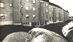 One of the original buildings at Svappavaara, designed by Ralph Erskine, which forms a long windbreak
 Windbreaks in Lesja Municipality, Norway, also used to collect snow in a dry area.


