Related Research Articles

The Dust Bowl was the result of a period of severe dust storms that greatly damaged the ecology and agriculture of the American and Canadian prairies during the 1930s. The phenomenon was caused by a combination of natural factors and human-made factors: a failure to apply dryland farming methods to prevent wind erosion, most notably the destruction of the natural topsoil by settlers in the region. The drought came in three waves: 1934, 1936, and 1939–1940, but some regions of the High Plains experienced drought conditions for as long as eight years.
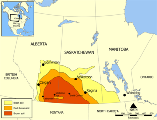
Palliser's Triangle, or the Palliser Triangle, is a semi-arid steppe occupying a substantial portion of the Western Canadian Canadian Prairies, Saskatchewan, Alberta and Manitoba, within the Great Plains region. While initially determined to be unsuitable for crops outside of the fertile belt due to arid conditions and dry climate, expansionists questioned this assessment, leading to homesteading in the Triangle. Agriculture in the region has since suffered from frequent droughts and other such hindrances.

A windbreak (shelterbelt) is a planting usually made up of one or more rows of trees or shrubs planted in such a manner as to provide shelter from the wind and to protect soil from erosion. They are commonly planted in hedgerows around the edges of fields on farms. If designed properly, windbreaks around a home can reduce the cost of heating and cooling and save energy. Windbreaks are also planted to help keep snow from drifting onto roadways or yards. Farmers sometimes use windbreaks to keep snow drifts on farm land that will provide water when the snow melts in the spring. Other benefits include contributing to a microclimate around crops, providing habitat for wildlife, and, in some regions, providing wood if the trees are harvested.

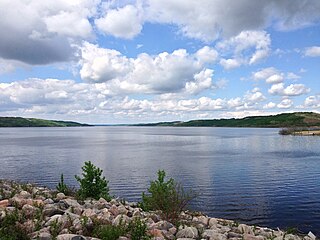
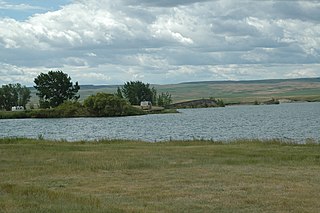
The Qu'Appelle River is a river in the Canadian provinces of Saskatchewan and Manitoba that flows 430 kilometres (270 mi) east from Lake Diefenbaker in south-western Saskatchewan to join the Assiniboine River in Manitoba, just south of Lake of the Prairies, near the village of St. Lazare. It is in a region called the Prairie Pothole Region of North America, which extends throughout three Canadian provinces and five U.S. states. It is also within Palliser's Triangle and the Great Plains ecoregion.

Hippophae is the genus of sea buckthorns, deciduous shrubs in the family Elaeagnaceae. The name sea buckthorn may be hyphenated to avoid confusion with the unrelated true buckthorns. It is also referred to as sandthorn, sallowthorn, or seaberry. It produces orange-yellow berries, which have been used over centuries as food, traditional medicine, and skin treatment in Mongolia, Ladakh, Russia, Ukraine, and northern Europe, which are its origin regions.

Indian Head is a town in southeast Saskatchewan, Canada, 69 kilometres (43 mi) east of Regina on the Trans-Canada Highway. It "had its beginnings in 1882 as the first settlers, mainly of Scottish origin, pushed into the area in advance of the railroad, most traveling by ox-cart from Brandon." "Indian" refers to Indigenous peoples in Canada. The town is known for its federally operated experimental farm and tree nursery, which has produced and distributed seedlings for shelter belts since 1901. For many years the program was run by the Prairie Farm Rehabilitation Administration (PFRA).
Agriculture and Agri-Food Canada is the department of the Government of Canada responsible for the federal regulation of agriculture, including policies governing the production, processing, and marketing of all farm, food, and agri-based products. Agriculture in Canada is a shared jurisdiction and the department works with the provinces and territories in the development and delivery of policies and programs.
Robert Weir, was a Canadian politician.
The Shellmouth Reservoir is a man-made reservoir on the Assiniboine River in Manitoba and Saskatchewan, Canada.

Canada is one of the largest agricultural producers and exporters in the world. As with other developed nations, the proportion of the population agriculture employed and agricultural GDP as a percentage of the national GDP fell dramatically over the 20th century, but it remains an important element of the Canadian economy. A wide range of agriculture is practised in Canada, from sprawling wheat fields of the prairies to summer produce of the Okanagan valley. In the federal government, overview of Canadian agriculture is the responsibility of the Department of Agriculture and Agri-Food.
Hays is a hamlet in southern Alberta, Canada within the Municipal District of Taber. It is located at the intersection of Highway 524 and Highway 875 between Vauxhall and Redcliff. The Bow River is 3.3 kilometres (2.1 mi) to the north of the hamlet and the Oldman River is approximately 19 kilometres (12 mi) to the south. These two rivers converge to form the South Saskatchewan River approximately 20 kilometres (12 mi) to the southeast.
Ulmus davidianavar.japonica 'Thomson' is a hardy, cold-resistant cultivar of the Japanese Elm assessed by the Prairie Farm Rehabilitation Administration (PFRA) Nursery at Indian Head, Saskatchewan, in the 1970s as part of its shelterbelt tree research..
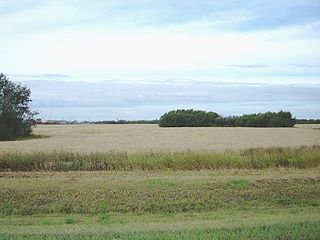
Agriculture in Saskatchewan is the production of various food, feed, or fiber commodities to fulfill domestic and international human and animal sustenance needs. The newest agricultural economy to be developed in renewable biofuel production or agricultural biomass which is marketed as ethanol or biodiesel. Plant cultivation and livestock production have abandoned subsistence agricultural practices in favor of intensive technological farming resulting in cash crops which contribute to the economy of Saskatchewan. The particular commodity produced is dependent upon its particular biogeography or ecozone of Geography of Saskatchewan. Agricultural techniques and activities have evolved over the years. The first nation nomadic hunter-gatherer lifestyle and the early immigrant ox and plow farmer proving up on his quarter section of land in no way resemble the present farmer operating huge amounts of land or livestock with their attendant technological mechanization. Challenges to the future of Saskatchewan agriculture include developing sustainable water management strategies for a cyclical drought prone climate in south western Saskatchewan, updating dryland farming techniques, stabilizing organic definitions or protocols and the decision to grow, or not to grow genetically modified foods. Domestically and internationally, some commodities have faced increased scrutiny from disease and the ensuing marketing issues.
Milk River Ridge Reservoir is an artificial lake in southern Alberta, Canada. It is located about 44 kilometres (27 mi) south-east of Lethbridge, along Highway 506, west of Highway 4 and is a popular spot for summer activities.

The Great Plan for the Transformation of Nature, also known as Stalin's plan for the transformation of nature, was proposed by Joseph Stalin in the Soviet Union in the second half of the 1940s, for land development, agricultural practices and water projects to improve agriculture in the nation. Its propaganda motto and catchphrase was "the great transformation of nature".
The economy of Saskatchewan has been associated with agriculture resulting in the moniker "Bread Basket of Canada" and Bread Basket of the World. According to the Government of Saskatchewan, approximately 95% of all items produced in Saskatchewan, depend on the basic resources available within the province. Various grains, livestock, oil and gas, potash, uranium, wood and their spin off industries fuel the economy.

The Great Plains Shelterbelt was a project to create windbreaks in the Great Plains states of the United States, that began in 1934. President Franklin D. Roosevelt initiated the project in response to the severe dust storms of the Dust Bowl, which resulted in significant soil erosion and drought. The United States Forest Service believed that planting trees on the perimeters of farms would reduce wind velocity and lessen evaporation of moisture from the soil. By 1942, 220 million trees had been planted, covering 18,600 square miles (48,000 km2) in a 100-mile-wide zone from Canada to the Brazos River. Even as of 2007, "the federal response to the Dust Bowl, including the Prairie States Forestry Project which planted the Great Plains Shelterbelt and creation of the Soil Erosion Service, represents the largest and most-focused effort of the [U.S.] government to address an environmental problem".
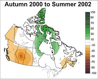
Prolonged, large-area droughts are among Canada's costliest natural disasters having major impacts on a wide range of sectors including agriculture, forestry, industry, municipalities, recreation, human health, society and ecosystems. They frequently stress water availability by depleting soil moisture, reducing stream flows, lowering lake and reservoir levels, and diminishing groundwater supplies. This ultimately affects several economic activities including for example, decreased agricultural production, less hydro-electric power generation, and increased freshwater transportation costs. Droughts also create major environmental hazards such as reduced water quality, wetland loss, soil erosion and degradation, and ecological habitat destruction.
The Drought Research Initiative (DRI) was established to better understand the characteristics and processes influencing Canadian Prairie droughts and better predict them, focusing on the severe drought which began in 1999 and largely ended in 2005. It is an interdisciplinary effort involving 15 funded investigators from six Canadian universities, over 20 collaborators from other universities and federal laboratories, and partners from three provincial governments. The DRI focuses on five research themes: quantification, understanding, prediction, comparisons with other droughts, and implications for society. Details may be found in Stewart et al. (2008) and on the DRI website.

John Walker was a Canadian horticulturist and plant breeder who developed numerous varieties of trees and shrubs. His selections have been used in shelterbelts and landscaping applications across Canada and in northern countries around the world. Some of his selections include:
References
- ↑ "Prairie Farm Rehabilitation Administration (PFRA) | The Canadian Encyclopedia". www.thecanadianencyclopedia.ca. Retrieved 2022-01-22.
- ↑ "Agri-Environment Services Branch" . Retrieved 14 May 2013.
- ↑ "Gov't axes shelterbelt program | The Western Producer". The Western Producer. 2012-04-19. Retrieved 2018-06-26.