
The Tarim Basin deciduous forests and steppe is a temperate broadleaf and mixed forests ecoregion in the Xinjiang Uyghur Autonomous Region of western China. The ecoregion includes deciduous riparian forests and steppes sustained by the region's rivers in an otherwise arid region.
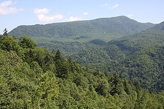
The Caucasus mixed forests is a temperate broadleaf and mixed forests ecoregion in the Caucasus Mountains, as well as the adjacent Lesser Caucasus range and the eastern end of the Pontic Mountains.
The Northeastern Himalayan subalpine conifer forests are a temperate coniferous forests ecoregion of the middle to upper elevations of the eastern Himalayas and southeast Tibetan Plateau. The ecoregion occurs in southeastern Tibet Autonomous Region, China, in northern and eastern Arunachal Pradesh, India, and extreme eastern Bhutan.

The Western Himalayan subalpine conifer forests is a temperate coniferous forests ecoregion of the middle and upper elevations of the western Middle Himalayas of Nepal, India, and Pakistan.

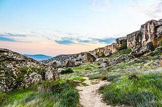
The Eastern Anatolian montane steppe is a temperate grasslands, savannas, and shrublands ecoregion. It is located in the Armenian Highlands, covering parts of eastern Turkey, Armenia, Azerbaijan, southern Georgia, and northwestern Iran.

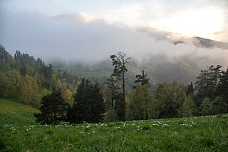
The Qionglai-Minshan conifer forests are a World Wide Fund for Nature ecoregion in Southwest China. These forests are classified as temperate coniferous forests and are part of the Palearctic realm.

The Guizhou Plateau broadleaf and mixed forests are a subtropical moist broadleaf forest ecoregion in the Yungui Plateau of China. Much of the original forest has been replaced by secondary forests.

The Ussuri broadleaf and mixed forests ecoregion covers a mountainous areas above the lower Amur River and Ussuri River in Primorsky Krai and Khabarovsk Krai in the Russian Far East. The ecoregion is in the Palearctic realm, with a Humid Continental climate. It covers 187,357 km2 (72,339 sq mi).
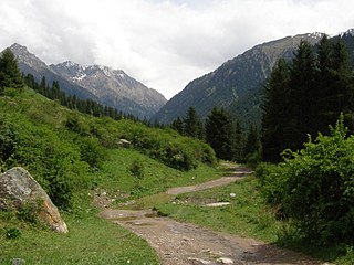
The Tian Shan montane conifer forests ecoregion covers the "forest belt" of the Tian Shan mountains - generally the north-facing slopes that get enough moisture, and are warm enough, for trees to grow. This conifer belt is found mostly between 1,500 and 2,700 meters.

The Tian Shan foothill arid steppe ecoregion covers the northern and western approaches to the Tian Shan mountains, centered on Lake Issyk-Kul in Kyrgyzstan. This region receives more moisture from Central Asia, thereby supporting more vegetation and diversity of plant and animal species than the deserts to the south.

The Central Asian riparian woodlands ecoregion is spread out across the deserts and plains of central Asia between the Aral Sea and the mountains 2,000 kilometres (1,200 mi) to the east. The long narrow components of the ecoregion follow the large rivers fed by snowmelt, and provide critical habitat for migratory birds as they travel through the arid region. The vegetation is referred to as tugai, characterized by low tangles of trees and brush along the edges of the rivers and associated wetlands, and fed by groundwater instead of precipitation.
The Gissaro-Alai open woodlands ecoregion covers the western foothills winding around two western offshoots of the Tian Shan Mountains in western Tajikistan, and parts of eastern Uzbekistan and western Kyrgyzstan, in Central Asia. The woodlands are typically of Juniper trees and shrubs, fitting the altitude zone situated between the desert valley floor, and the tree line, above which the mountain ridges are glaciated and barren.

The Nihonkai montane deciduous forests ecoregion covers the Nihonkai mountain slopes of Japan's central island of Honshu, including most of the northern half of the island. Also included in the ecoregion are the forested lowland hills of the Oshima Peninsula, which is the southern extension of Hokkaido Island.

The Nihonkai evergreen forests ecoregion covers a thin strip of land on the western coast of the island of Honshu in Japan. It is bounded on the east by the Nihonkai montane deciduous forests ecoregion.

The Hokkaidō deciduous forests ecoregion covers the northern and southern coasts of the island of Hokkaido, the northernmost of the main islands of Japan. The region sits in the transition zone between the colder subarctic forests to the north and the more temperate forests to the south. Characteristic trees include Mongolian oak, Basswood, and Ash trees.
The Hokkaido montane conifer forests ecoregion covers the mountainous central regions of Hokkaido Island, the northernmost of Japan's main islands. Forests of spruce and fir thrive in the subalpine, cool climate. On the northeastern edge of the island, the conifer forests extend down to the sea under the influence of the cold Oyashio Current coming down from the north, although logging in recent years has put pressure on these stands.
The Azerbaijan shrub desert and steppe is a deserts and xeric shrublands ecoregion in western Asia. It lies in the lowlands west of the Caspian Sea, and covers portions of Azerbaijan, Georgia, and Iran.

The Central Afghan Mountains xeric woodlands ecoregion covers the xeric (dry) eastern and southern slopes of the central mountain range of Afghanistan, between the sandy desert to the south and the alpine meadows in the higher, wetter region to the north. Despite the 'woodlands' in the ecoregion name, very little of the territory is forested – less than 1% – but is instead sparse vegetation or herbaceous cover.

The Paropamisus xeric woodlands ecoregion covers the portion of northeastern Afghanistan north of the central mountain range and the Hindu Kush Mountains. The name is derived from the Old Persian name for the region, Parupraesanna. While there are low canopy woodlands in the northeast of the ecorgegion, most of the territory is desert or xeric (dry) scrubland.

The Baluchistan xeric woodlands ecoregion covers the middle elevations of a series of mountain ranges of western Pakistan and northeastern Afghanistan, reaching 1,200 kilometres (750 mi) from the Arabian Sea in the south to the Hindu Kush Mountains and the Himalayas in the north. The characteristic vegetation is xeric (dry) woodlands of shrubs and herbaceous cover. The region has rich biodiversity but relatively few endemic species.


