 Stepping stones, River Doe between Dale House and Twistleton Dale House
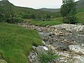 Stream confluence at head of River Doe.
 Baxengill Gorge, River Doe, near Ingleton
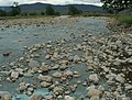 Wide flood-bed of River Doe
| River Doe | |
|---|---|
 River Doe near Ingleton, flowing over Beezley Falls | |
 | |
| Location | |
| Country | England |
| Physical characteristics | |
| Source | |
| • location | God's Bridge nr Chapel-Le-Dale |
| • coordinates | 54°10′58″N2°24′40″W / 54.18278°N 2.41111°W |
| • elevation | 234 metres (768 ft) |
| Mouth | |
• location | Confluence with River Twiss at Ingleton |
• coordinates | 54°9′12″N2°28′15″W / 54.15333°N 2.47083°W |
• elevation | 118 metres (387 ft) |
| Length | 5.92 km (3.68 mi) |
The River Doe is a river in North Yorkshire, England. The river's source is near God's Bridge close to the settlement of Chapel-le-Dale and flows through Twisleton in a south-westerly direction to Ingleton, where it meets the River Twiss to form the River Greta. The river forms part of the River Lune system that flows into the Irish Sea.


