Chapel-le-Dale

Last updated

Chapel-le-Dale
St Leonards Church Chapel le Dale (geograph 1789053).jpg
St Leonards Church
North Yorkshire UK location map (2023).svg
Red pog.svg
Chapel-le-Dale
Location within North Yorkshire
OS grid reference SD739769
Unitary authority
Ceremonial county
Region
Country England
Sovereign state United Kingdom
Post town Carnforth
Postcode district LA6
Police North Yorkshire
Fire North Yorkshire
Ambulance Yorkshire
UK Parliament
List of places
UK
England
Yorkshire
54°11′17″N2°24′02″W / 54.1881°N 2.4006°W / 54.1881; -2.4006

Chapel-le-Dale is a hamlet in the civil parish of Ingleton, North Yorkshire, England. It is in the Yorkshire Dales National Park in a valley of the same name, and was previously in the West Riding of Yorkshire.

Contents

History

The hamlet is situated on the B6255 road between Ingleton and Ribblehead near to the Ribblehead Viaduct. The name derives from Old French and literally means Chapel in the valley. [1] It was first recorded as Chappell ith Dale in 1677. [2] Historically, the hamlet, and its parish, were both in the Wapentake of Ewcross and up until 1974, they were in the West Riding of Yorkshire. [3] [4] In 1892, the hamlet was recorded as having a population of 150. Modern-day population statistics are recorded within the Civil Parish of Ingleton. [5] [6]

The hamlet is in close proximity to Ingleborough and Whernside and there are several potholes in the vicinity, [7] the best known being Great Douk Cave. There is a pub in the village, The Old Hill Inn, which is used as a starting and ending point for various walks on Whernside or Ingleborough. [8] The source of the River Doe is nearby.
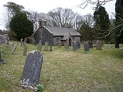
There is a church in the hamlet (The Church of St Leonard) which is now a grade II listed building. It was used as a burial plot for the navvies, and their family members, who died whilst constructing the nearby Ribblehead Viaduct between 1869 and 1876. In all, over 200 people died during the construction from accidents and outbreaks of smallpox. A plaque was erected in the church to their memory. [9] [10] [11] Previous to the railway's construction, deaths and burials in the dale numbered between two and four people each year on average. A survey of the parish records from 1876 showed the average of 44 burials per year between 1870 and 1875. [12]

Related Research Articles

<span class="mw-page-title-main">Yorkshire Dales</span> Upland area of the Pennines in Northern England

The Yorkshire Dales are an upland area of the Pennines in England. Most of the area is in the county of North Yorkshire, but it extends into Cumbria and a small part of Lancashire. It was historically entirely within Yorkshire. The majority of the Dales are part of the Yorkshire Dales National Park, created in 1954. The exception is the area around Nidderdale, which forms the separate Nidderdale Area of Outstanding Natural Beauty.

<span class="mw-page-title-main">Settle–Carlisle line</span> Railway line in northern England

The Settle–Carlisle line is a 73-mile-long (117 km) main railway line in northern England. The route, which crosses the remote, scenic regions of the Yorkshire Dales and the North Pennines, runs between Settle Junction, on the Leeds–Morecambe line, and Carlisle, near the English-Scottish borders. The historic line was constructed in the 1870s and has several notable tunnels and viaducts such as the imposing Ribblehead.

<span class="mw-page-title-main">Ribblehead Viaduct</span> Railway viaduct in North Yorkshire, England

The Ribblehead Viaduct or Batty Moss Viaduct carries the Settle–Carlisle railway across Batty Moss in the Ribble Valley at Ribblehead, in North Yorkshire, England. The viaduct, built by the Midland Railway, is 28 miles (45 km) north-west of Skipton and 26 miles (42 km) south-east of Kendal. It is a Grade II* listed structure. Ribblehead Viaduct is the longest and the third tallest structure on the Settle–Carlisle line.

<span class="mw-page-title-main">Yorkshire Three Peaks</span> Mountainous peaks in the Yorkshire Dales National Park

The mountains of Whernside, Ingleborough and Pen-y-ghent are collectively known as the Three Peaks. The peaks, which form part of the Pennine range, encircle the head of the valley of the River Ribble in the Yorkshire Dales National Park in the North of England.

<span class="mw-page-title-main">Whernside</span> Mountain in the Yorkshire Dales, England

Whernside is a mountain in the Yorkshire Dales in Northern England. It is the highest of the Yorkshire Three Peaks, the other two being Ingleborough and Pen-y-ghent. It is the highest point in the ceremonial county of North Yorkshire and the historic West Riding of Yorkshire with the summit lying on the county boundary with Cumbria. It is the fifteenth most prominent hill in England.

<span class="mw-page-title-main">Ingleborough</span> Mountain in the Yorkshire Dales, England

Ingleborough is the second-highest mountain in the Yorkshire Dales, England. It is one of the Yorkshire Three Peaks, and is frequently climbed as part of the Three Peaks walk. A large part of Ingleborough is designated as a Site of Special Scientific Interest and National Nature Reserve and is the home of a new joint project, Wild Ingleborough, with aims to improve the landscape for wildlife and people.

<span class="mw-page-title-main">Kettlewell</span> Village in North Yorkshire, England

Kettlewell is a village in Upper Wharfedale, North Yorkshire, England. Historically part of the West Riding of Yorkshire, it lies 6 miles (10 km) north of Grassington, at the point where Wharfedale is joined by a minor road which leads north-east from the village over Park Rash Pass to Coverdale. Great Whernside rises to the east. The population of the civil parish was 322 at the 2011 census, with an estimated population of 340 in 2015.

<span class="mw-page-title-main">Horton in Ribblesdale</span> Village and civil parish in North Yorkshire, England

Horton in Ribblesdale is a small village and civil parish in the Craven district of North Yorkshire, England. It is situated in Ribblesdale on the Settle–Carlisle Railway to the west of Pen-y-ghent.

<span class="mw-page-title-main">Clapham, North Yorkshire</span> Village in North Yorkshire, England

Clapham is a village in the civil parish of Clapham cum Newby in the Craven district of North Yorkshire, England. It was previously in the West Riding of Yorkshire. It lies within the Yorkshire Dales National Park, 6 miles (10 km) north-west of Settle, and just off the A65 road.

<span class="mw-page-title-main">Ingleton, North Yorkshire</span> Village and civil parish in North Yorkshire, England

Ingleton is a village and civil parish in the Craven district of North Yorkshire, England. The village is 19 miles (30 km) from Kendal and 17 miles (28 km) from Lancaster on the western side of the Pennines. It is 9.3 miles (15 km) from Settle. The River Doe and the River Twiss meet to form the source of the River Greta, a tributary of the River Lune. The village is on the A65 road and at the head of the A687. The B6255 takes the south bank of the River Doe to Ribblehead and Hawes. All that remains of the railway in the village is the landmark Ingleton Viaduct. Arthur Conan Doyle was a regular visitor to the area and was married locally, as his mother lived at Masongill from 1882 to 1917. It has been claimed that there is evidence that the inspiration for the name Sherlock Holmes came from here.

<span class="mw-page-title-main">Hellifield</span> Village and civil parish in North Yorkshire, England

Hellifield is a village and civil parish in the Craven district of North Yorkshire, England. Historically part of the West Riding of Yorkshire, the village was once an important railway junction on the Settle-Carlisle Railway between the Midland Railway and the Lancashire and Yorkshire Railway, but Hellifield railway station is now a shadow of its former glory. It is situated on the A65, between Skipton and Settle. Hellifield had a population of 1,060 residents at the 2001 census, increasing to 1,426 at the 2011 census.

<span class="mw-page-title-main">Austwick</span> Village and civil parish in North Yorkshire, England

Austwick is a village and civil parish in the Craven district of North Yorkshire, England, about 5 miles (8 km) north-west of Settle. The village is on the edge of the Yorkshire Dales National Park.

<span class="mw-page-title-main">Burton in Lonsdale</span> Village and civil parish in North Yorkshire, England

Burton in Lonsdale is a village and civil parish in the Craven District of North Yorkshire, England, close to the border with Lancashire and Cumbria. It is in Lonsdale. The parish is approximately 1,500 acres (6 km2) in area and has many farms – dairy, beef and sheep. Little is grown, except grass to feed the animals.

<span class="mw-page-title-main">Ribblehead railway station</span> Railway station in North Yorkshire, England

Ribblehead is a railway station on the Settle and Carlisle Line, which runs between Carlisle and Leeds via Settle. The station, situated 52 miles 17 chains (84 km) north-west of Leeds, serves the area of Ribblehead, Craven in North Yorkshire, England. It is owned by Network Rail and managed by Northern Trains.

<span class="mw-page-title-main">White Scar Caves</span> Show cave in North Yorkshire, England

White Scar Caves is a show cave in the civil parish of Ingleton, North Yorkshire, England, under Ingleborough in the Chapel-le-Dale valley of the Yorkshire Dales National Park. It is a solutional resurgence cave formed in Carboniferous limestone, some 6 kilometres (3.7 mi) long.

<span class="mw-page-title-main">Ribblehead</span> Area near the River Ribble in North Yorkshire, England

<span class="mw-page-title-main">Scar End</span> Hamlet in North Yorkshire, England

Scar End is a settlement on the side of Twisleton Scar in the English county of North Yorkshire.

<span class="mw-page-title-main">Dales High Way</span>

A Dales High Way is a long-distance footpath in northern England. It is 90 miles (140 km) long and runs from Saltaire in West Yorkshire to Appleby-in-Westmorland, Cumbria, roughly parallel to the line of the Settle and Carlisle Railway.

<span class="mw-page-title-main">Richmond to Lancaster Turnpike</span> Former road in Northern England

The Richmond to Lancaster Turnpike, was a road that was opened in the second half of the 18th century between Richmond, in the North Riding of Yorkshire and Lancaster in Lancashire, Northern England. The turnpike was built to allow goods to be taken from Yorkshire to the port of Lancaster. It was approved in 1751, but was not wholly completed until 1774.

<span class="mw-page-title-main">Chapel-le-Dale (valley)</span> Valley in the Yorkshire Dales, England

Chapel-le-Dale is west-facing valley in the Yorkshire Dales, England. The U-shaped valley of Chapel-le-Dale is one of the few which drain westwards towards the Irish Sea, however, the river that flows through the valley has several names with the Environment Agency and the Ordnance Survey listing it as the River Doe. However, some older texts insist the name of the watercourse through the dale is the River Greta, which runs from a point below the hamlet of Chapel-le-Dale, and onwards past Ingleton. The dale is sparsely populated with only one settlement, the hamlet of Chapel-le-Dale, which has a small chapel.

References

  1. Chrystal, Paul (2017). The Place Names of Yorkshire. Catrine: Stenlake. p. 25. ISBN   9781840337532.
  2. "Archaeological survey in Chapel-le-Dale, North Yorkshire" (PDF). outofoblivion.org.uk. The Brigantia Archaeological Practice. June 2001. p. 10. Retrieved 2 January 2018.
  3. "Genuki: In 1822, the following places were in the Parish of Low Bentham:, Yorkshire (West Riding)". www.genuki.org.uk. Retrieved 2 January 2018.
  4. "History of Chapel le Dale, in Craven and West Riding | Map and description". www.visionofbritain.org.uk. Retrieved 2 January 2018.
  5. Speight, Harry (1892). The Craven and North-west Yorkshire Highlands. London: Elliot Stock. p. 245. OCLC   7219082.
  6. UK Census (2011). "Local Area Report – Ingleton Parish (E04007098)". Nomis. Office for National Statistics . Retrieved 14 July 2023.
  7. Buckley, Norman (1995). Yorkshire Dales walking : on the level (3 ed.). Wilmslow: Sigma Leisure. p. 65. ISBN   1-85058-439-7.
  8. Upton, Hannah (20 February 2013). "REVIEW: Old Hill Inn, Chapel-le-Dale". The Westmorland Gazette. Retrieved 2 January 2018.
  9. Moore, Lindsey (20 November 2014). "Life and death on the Settle-Carlisle". Craven Herald. Retrieved 2 January 2018.
  10. Historic England. "Church of St Leonard (Grade II) (1213046)". National Heritage List for England . Retrieved 2 January 2018.
  11. "Plaque to be unveiled in memory of railway workers". Craven Herald. 4 August 2000. Retrieved 2 January 2018.
  12. Carr, Joseph (1876). A Guide to the Caves, Mountains, River Scenery and other remarkable natural curiosities in the neighbourhood of Ingleton and Clapham. Lancaster: Milner. p. 22. OCLC   643588166.