Last updated • 6 min readFrom Wikipedia, The Free Encyclopedia
River in Calderdale, England
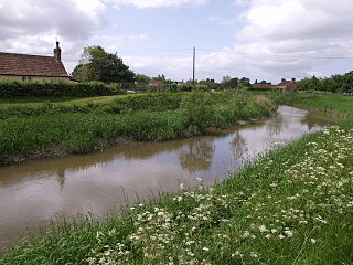
Hebden Water (alternative name: River Hebden)[1] is a short river in Calderdale, West Yorkshire, flowing for about 7.5 kilometres (4.7mi) generally south-eastward from the confluence of two upland streams, Graining Water and Alcomden Water, to the River Calder at Hebden Bridge. Its wooded valley is a much-visited beauty spot, but it has many times flooded in its lower stretches.
The name is first recorded in 1279 as aqua de Heppedene. Hebden comes from Old English hēopa + denu, meaning 'bramble or wild rose valley'.[2]
Course
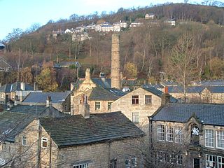
Gibson Mill on Hebden Water
Hebden Water is formed by the union of two streams: Graining Water, which flows generally south-eastward, and Alcomden Water, which flows generally southward, both rising near the Lancashire/West Yorkshire county boundary on the southern slopes of Boulsworth Hill. One of the headwaters of Graining Water, Old Hay Dike, feeds Widdop Reservoir, while another, Reaps Water, feeds Gorple Upper and Lower reservoirs. Alcomden Water has been dammed in three places to form Walshaw Dean Upper, Middle, and Lower Reservoirs. Hebden Water, beginning between Blake Dean and Black Dean at Grid Reference SD959314, flows first eastward and then southward through a steep-sided wooded valley, Hebden Dale, passing Gibson Mill and the rocks of Hardcastle Crags. It then turns eastward and is joined from the north by Crimsworth Dean Beck before reverting to a southward course. The valley opens out somewhat as it approaches the town of Hebden Bridge. In Hebden Bridge the river debouches into the River Calder at Grid Reference SD991271.[3]
Topography and hydrology
Hebden Water is approximately 7.5 kilometres (4.7mi) in length.[4] The catchment of Hebden Water covers an area of 59 square kilometres (23sqmi), of which about 20 square kilometres (7.7sqmi) in the upper reaches drain into the reservoirs mentioned above.[5] The water quality of the river was in 2019 recorded as moderate for ecological status (likewise in 2022), but it failed on the score of its chemical composition.[4] The lower stretches are prone to flooding, which has often impacted the town of Hebden Bridge,[6][7] but measures to reduce the risk of flood have been undertaken by the National Trust, which owns most of the upper section of the river, and the volunteer group Slow the Flow. These include the creation of leaky dams on feeder streams and the thinning of woodland to encourage undergrowth.[8]
The wooded valley of the Hebden Water, considered attractive and picturesque, has a history of attracting visitors as a picnic spot on Sundays and Bank Holidays. There are public footpaths running along the river's banks for most of its length, and Hebden Water itself has been called "probably the best local run of its kind in West Yorkshire" for canoeists and kayakers.[9][10][3]
Standing on the banks of Hebden Water is Gibson Mill, one of the earliest Industrial Revolutioncotton mills, dating from c. 1800. It is now a Grade II listed building, and has been renovated by its owner, the National Trust, as a visitor and education attraction.[11]
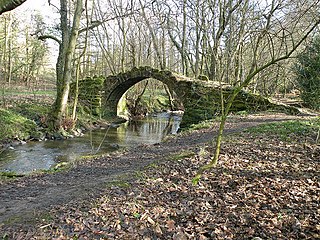
Hebden Water is in its short course crossed by six bridges listed for their architectural interest, at Grade II unless otherwise stated. These are West End Bridge, West End, Hebden Bridge, built in 1771–1772;[12] the Old Bridge, Bridge Gate, Hebden Bridge, built c. 1510 (Grade II*, also a scheduled monument);[13][14] St George's Bridge, St George's Square, Hebden Bridge, built in 1892;[15] Foster Mill Bridge, Slater Bank Lane, Hebden Bridge, probably built in the late 18th century;[16] New Bridge, Midge Hole Road, Wadsworth, built in the 18th or early 19th century;[17] and Gibson's Bridge, Hardcastle Crags, Heptonstall, built in the early 19th century.[18] There are also early 19th-century Grade II listed bridges over Graining Water at Blake Dean,[19] and over Alcomden Water at Holme Ends.[20]
Citations
↑ Berry, Chris (16 November 2013). "Tales of the Riverbank". Yorkshire Post. Leeds. Retrieved 1 September 2024.
↑ Watts, Victor, ed. (2004). The Cambridge Dictionary of English Place-Names. Cambridge: Cambridge University Press. p.293. ISBN9780521362092.
Mytholmroyd is a large village and former civil parish, now in the parish of Hebden Royd, in the Calderdale district, in West Yorkshire, England, 2 miles (3 km) east of Hebden Bridge. It lies in the Upper Calder Valley, 10 miles (16 km) east of Burnley and 7 miles (11 km) west of Halifax. The village, which has a population of approximately 4,000, is in the Luddendenfoot Ward of Calderdale Council.
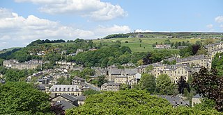
Hebden Bridge is a market town in the Calderdale district of West Yorkshire, England. It is in the Upper Calder Valley, 8 miles (13 km) west of Halifax and 14 miles (21 km) north-east of Rochdale, at the confluence of the River Calder and the Hebden Water. The town is the largest settlement in the civil parish of Hebden Royd.
The River Don is a river in South Yorkshire and the East Riding of Yorkshire, England. It rises in the Pennines, west of Dunford Bridge, and flows for 69 miles (111 km) eastwards, through the Don Valley, via Penistone, Sheffield, Rotherham, Mexborough, Conisbrough, Doncaster and Stainforth. It originally joined the Trent, but was re-engineered by Cornelius Vermuyden as the Dutch River in the 1620s, and now joins the River Ouse at Goole. Don Valley is a UK parliamentary constituency near the Doncaster stretch of the river.
The River Tone is a river in the English county of Somerset. The river is about 33 kilometres (21 mi) long. Its source is at Beverton Pond near Huish Champflower in the Brendon Hills, and is dammed at Clatworthy Reservoir. The reservoir outfall continues through Taunton and Curry and Hay Moors, which are designated as a Site of Special Scientific Interest. Finally, it flows into the River Parrett at Burrowbridge.
The River Ryton is a tributary of the River Idle. It rises close to the Chesterfield Canal near Kiveton Park, and is joined by a series of tributaries near Lindrick Common in the Metropolitan Borough of Rotherham, South Yorkshire, England. Most of its course is in Nottinghamshire, flowing through the town of Worksop. It meanders northwards to join the River Idle near the town of Bawtry on the South Yorkshire-Nottinghamshire border.
The River Kent is a short river in the county of Cumbria in England. It originates in hills surrounding Kentmere, and flows for around 20 miles (32 km) into the north of Morecambe Bay. The upper reaches and the western bank of the estuary are located within the boundaries of the Lake District National Park. The river flows in a generally north to south direction, passing through Kentmere, Staveley, Burneside, Kendal and Sedgwick. Near Sedgwick, the river passes through a rock gorge which produces a number of low waterfalls. This section is popular with kayakers as it offers high quality whitewater for several days after rain. The village of Arnside is situated on the east bank of the Kent estuary, just above Morecambe Bay, and a tidal bore known as the Arnside Bore forms in the estuary at this point on high spring tides.
Hebden Royd is a civil parish in the Metropolitan Borough of Calderdale in West Yorkshire, England. According to the 2001 census it had a population of 9,092, rising to 9,558 at the 2011 census. It includes market town of Hebden Bridge and the villages of Mytholmroyd and Cragg Vale. The parish was an urban district before 1974, created in 1937 by the merger of Hebden Bridge and Mytholmroyd urban districts.
Hardcastle Crags is a wooded Pennine valley in West Yorkshire, England, owned by the National Trust. Historically part of the West Riding of Yorkshire, it lies approximately 2 miles (3.2 km) north of the town of Hebden Bridge and 10 miles (16 km) west of the town of Halifax. It gave the title to a poem by Sylvia Plath that was included in her 1960 debut collection The Colossus.
The Blackburn Brook is a stream in Sheffield, South Yorkshire, England which flows through the Blackburn Valley along the M1 and Ecclesfield Road and joins the River Don near the Meadowhall shopping centre. Downstream from the A61 road at Chapeltown the Blackburn Brook is defined as a main river by the Environment Agency, which requires new building development to be at least 26 feet (8 m) from the bank side as a flood defence measure and to allow access to the watercourse for maintenance.
Hebden is a village and civil parish in the former Craven District of North Yorkshire, England, and one of four villages in the ecclesiastical parish of Linton. It lies near Grimwith Reservoir and Grassington, in Wharfedale in the Yorkshire Dales National Park. In 2011 it had a population of 246.
The River Went is a river in Yorkshire, England. It rises close to Featherstone and flows eastward, joining the River Don just to the north of Pincheon Green.
The River Calder is a river in West Yorkshire, in Northern England.
The River Dove is a river that extends through the Low Valley in Barnsley, England. It flows from Worsbrough Reservoir to its confluence with the River Dearne.
The Eller Beck is a small river in North Yorkshire, England, that flows through the town of Skipton and is a tributary of the River Aire. Its channel was heavily modified to supply water to mills in the 18th and 19th centuries, and although all the mills have closed, the water now supplies power to the National Grid, generated by a turbine at High Corn Mill. The beck flows through several underground culverts in Skipton that contribute to the flood risk. To alleviate flooding in Skipton town centre, a scheme involving two flood water storage reservoirs was designed and eventually completed in 2017.
Harden Beck is a stream that flows from Hewenden Reservoir, over Goit Stock Waterfall to the River Aire in Bingley, West Yorkshire. The route starts out further up the valley as Denholme Beck, Hewenden Beck and Hallas Beck. Its waters are fed by Thornton Moor Reservoir, Stubden Reservoir, Doe Park Reservoir and Hewenden Reservoir.
The Blake Dean Railway was an approximately 5.5 miles (9 km) long 3 ft gauge narrow gauge railway on the edge of Hardcastle Crags Valley in West Yorkshire. It went from Heptonstall to the dam construction sites of the Walshaw Dean Reservoirs.
The Sea Cut (Scalby Beck) is a small river that enters the North Sea at Scalby Mills, Scarborough, North Yorkshire, England. The beck is fed from local streams in Scalby, Newby and Burniston and other watercourses draining off the nearby hills. It is also a bypass channel for the upper reaches of the River Derwent when it is under flood conditions.
Pickering Beck is a river that runs for over 18 miles (29 km) from its source in the North York Moors National Park through the town of Pickering and on to its confluence with Costa Beck at Kirby Misperton. It is a meandering river that is fed by numerous named and unnamed becks and streams which flow over sandstone and limestone beds and an alluvia of sand, clay silt and gravel. The beck is known for flooding and in recent times has been a beneficiary of funding and experimental flood protection schemes.
The Worth Valley is a geographic area in West Yorkshire, England, that extends eastwards from Crow Hill and Oxenhope Moor, providing drainage for the River Worth for nearly 10 miles (16 km) to the River Aire. It is a side valley to Airedale, with the River Worth being a major tributary of the River Aire. The Worth Valley was important for its contribution to the textiles industry of the West Riding of Yorkshire and was furnished with several reservoirs to allow mills to operate within the valley. Most of the reservoirs are still in use into the modern day.
Oak Beck is a watercourse that flows eastwards across the northern part of Harrogate in North Yorkshire, England. The beck flows through a broad V-shaped valley, before emptying into the River Nidd at Bilton, just upstream from the Nidd Gorge Viaduct. Water from Oak Beck has been used as a water supply for Harrogate and also for industrial purposes further downstream.
This page is based on this Wikipedia article Text is available under the CC BY-SA 4.0 license; additional terms may apply. Images, videos and audio are available under their respective licenses.