Eller Beck

Last updated

Eller Beck
View from Back O The Beck - geograph.org.uk - 1282998.jpg
Eller Beck just below the Water Street culvert, showing the overflow from the canal and some redundant sluices which formerly controlled flow to the mills downstream.
Location
Country England
Counties North Yorkshire
Physical characteristics
Source 
  locationOut Fell
Mouth  
  location
River Aire below Skipton
Eller Beck
BSicon uexSTR.svg
Bilton Ings
BSicon uexSTRq.svg
BSicon uexABZg+r.svg
Black Sike
BSicon uexSTR.svg
Waterfall Gill
BSicon uexSTRq.svg
BSicon uexABZg+r.svg
Sandy Beck
BSicon uxmKRZu.svg
Railway bridge
BSicon uexSTRq.svg
BSicon uexABZg+r.svg
Owlet House Beck
BSicon uexSKRZ-Eu.svg
Tarn Moor Bridge
BSicon uexABZg+l.svg
BSicon uexSTRq.svg
Haw Beck
BSicon uexSKRZ-Au.svg
A65 bridge
BSicon uexSKRZ-Eu.svg
Footbridge in Skipton Woods
BSicon uexSTR.svg
Long Dam
BSicon uxWEIRr.svg
BSicon uextSTR+r.svg
Sluice and feeder
BSicon uxWEIRg.svg
BSicon uexDOCKS.svg
Weir and Round Dam
BSicon uexSTRq.svg
BSicon uexABZg+r.svg
Sougha Gill
BSicon uexSKRZ-Eu.svg
Footbridge in Skipton Woods
BSicon uexSTR+FEATURE@r.svg
Old Saw Mill
BSicon uexSTR.svg
BSicon ueWHRF.svg
Thanet Canal
BSicon uexDOCKS.svg
BSicon uexSTR.svg
BSicon uSTR.svg
High Corn Mill Dam
BSicon uexSTRl.svg
BSicon uxSTRbl.svg
BSicon uSTR.svg
High Corn Mill
BSicon uexSKRZ-Yu.svg
BSicon uSKRZ-Yu.svg
B6265 Mill Street bridge
BSicon uextSTRe.svg
BSicon uSTR.svg
Water Street culvert
BSicon gSTR+l.svg
BSicon uexSTR+l.svg
BSicon uxWEIRl.svg
BSicon uWEIRl.svg
Sluices and canal overflow
BSicon gDOCKS.svg
BSicon uexSTR.svg
BSicon uSTR.svg
Site of Mill Dam
BSicon gSTRl.svg
BSicon uxSTRbl.svg
BSicon uSTR.svg
Site of Millfields Mill
BSicon uexSKRZ-Eu.svg
BSicon uSKRZ-Eu.svg
Coach Street bridge
BSicon uextSTRe.svg
BSicon uSTR.svg
Coach Street culvert
BSicon uCONTgq.svg
BSicon uxKRZu.svg
BSicon uFABZqlr.svg
Leeds and Liverpool Canal
BSicon uextSTRa.svg
Belmont Street culvert
BSicon uexSKRZ-Au.svg
A6069 Belmont Street bridge
BSicon uextSTRa.svg
Morrisons carpark culvert
BSicon uextABZg+l.svg
BSicon uextSTReq.svg
Jn with Waller Hill Beck
BSicon BHFq.svg
BSicon uxmtKRZ.svg
BSicon STRq.svg
Skipton Railway Station
BSicon uextSTRe.svg
BSicon uexSKRZ-Eu.svg
Carleton New Road bridge
BSicon uexSKRZ-Eu.svg
Carleton Road bridge
BSicon uexSKRZ-Eu.svg
bridge
BSicon uexSKRZ-Au.svg
A629 bridge
BSicon uexCONTgq.svg
BSicon uexFABZqlr.svg
BSicon uexCONTfq.svg
River Aire

The Eller Beck is a small river in North Yorkshire, England, that flows through the town of Skipton and is a tributary of the River Aire. Its channel was heavily modified to supply water to mills in the 18th and 19th centuries, and although all the mills have closed, the water now supplies power to the National Grid, generated by a turbine at High Corn Mill. The beck flows through several underground culverts in Skipton that contribute to the flood risk. To alleviate flooding in Skipton town centre, a scheme involving two flood water storage reservoirs was designed and eventually completed in 2017.

Contents

Course

Eller Beck is formed by streams that rise in the hills to the north of Skipton. They include Black Sike, which rises above the 1,410-foot (430 m) contour on Out Fell, to the west of Upper Barden Reservoir, and several more which rise in Bilton Ings, close to the 1,395-foot (425 m) contour, to the south west of the reservoir. Along with water from a spring called Boiling Well, they form Waterfall Gill Beck, which becomes Eller Beck. It flows around the northern and western edges of Nettlehole Wood and Crookrise Wood, to be joined by Sandy Beck before passing under the freight-only railway line to Swinden Quarry. The railway bridge is below the 560-foot (170 m) contour. [1]

The railway follows the valley of the beck as it is joined by Owlet House Beck, passes under two farm access bridges, and under Tarn Moor Bridge, which carries a minor road to Embsay. [1] The bridge dates from the late 18th century and was altered in the mid 19th century. It has a single round arch, is constructed of squared rubble with stone dressings, and is a Grade II Listed structure. [2] The river then meanders through Skipton Golf Club, where it is a water hazard for the back nine holes, [3] before it is joined by Haw Beck, which flows from the east alongside the Embsay and Bolton Abbey Steam Railway for most of its length. It passes under the A65 Leeds to Kendal road through two large round tubes, to enter Skipton Woods. [1]

The river through the woods was engineered to provide water to power wool, corn and saw mills for two centuries. A dam across the river creates the stretch known as the Long Dam, and a sluice above the dam feeds water into the Round Dam, [4] from where water enters a culvert and a high-level channel, Sandy Goit, that once fed the mill near the entrance to the woods. Sougha Gill adds to the flow just below the dam, and further down, the water from the mill channel flows under the footpath through a stone lined channel to rejoin the river. [1] The mill, built by Peter Garforth, John Blackburn and John Sidgwick, started as a cotton mill in 1785. Wooden frames for spinning cotton yarn were powered by water, but the supply was not adequate to support two shifts, and production was scaled down. In 1825, the mill was extended, and the new section used steam power. [5] By 1882, some weaving was carried out at the mill, [6] but it was marked as disused on the 1891 Skipton Town plans. [7]

Town section

As the beck leaves the woods, it is separated from the Thanet Canal (or Springs Branch) by a high, narrow towpath. Some of the water enters the canal, but the main flow continues towards the town, through a channel which is in parts paved with stones. The pond for High Corn Mill is adjacent to the river, with an overflow into it. The mill was originally the Soke-Mill, first documented in 1310, when it was the only place where tenants of the Manor of Skipton were allowed to grind their corn, and had to pay a "mulcture toll", which entitled the miller to keep a proportion of the product. The Earl of Thanet protected the monopoly of the mill vigorously, and the toll was only lifted in the 19th century. The mill, and other properties owned by Skipton Castle Estates, was sold in 1954. It was acquired by George Leatt in 1965, who began a major programme of restoration. [8] A new waterwheel to replace the original wheel which was removed around 1900 was fitted in 1967. Since 2010, the water supply has been used to drive a water turbine supplying power to the national grid. The mill has been refurbished to provide accommodation for shops and businesses. [9] It straddles the beck with a single arch, and the present three-storey structure is thought to date from the 18th century. [10]

Below the mill, the river passes under a Grade II Listed bridge, dating from the 19th century, [11] which carries the B6265 at Mill Street, and continues through the first of several culverts that carry it under Skipton. It passes under Water Street, and then surfaces to run beside the canal. Some old sluices once controlled the flow to Mill Dam, which supplied the water for Millfields Mill, just above Coach Street. [12] In 1822, the mill was occupied by James Wilson, a spinner of worsted. The lower floor was used as a paper glazing mill, but from the 1840s, Messrs. Mason and Hallam used the entire building for spinning worsted. By 1882, it had become a spindle works, making spindles for the textile industry. [13] Mill Dam was shown on the 1969 map, but had become a car park by 1979. [14] The river continues, passing under Coach Street and some buildings, including a former chapel which was adapted to serve as a base for the fire engine, [15] before turning sharply to the south. It passes under the Leeds and Liverpool Canal, and under buildings and the A6069 at Belmont Street. The Environment Agency maintain a gauging station near Morrisons supermarket to measure water levels, [16] before the river enters a culvert, which carries it under the supermarket carpark to the east of Skipton railway station and the railway. Underground, it is joined by Waller Hill Beck, which is also known as Wilderness or Skibeden Beck, which is also partially culverted under Skipton. To the south of the railway, it runs through a business park, to the east of Sandylands playing fields, and past the Waltonwrays cemetery and crematorium. A final bridge carries it under the A629 Rotherham to Skipton road, before it joins the River Aire. [1]

Flood prevention

Skipton suffered from flooding in 1908, 1979, 1982, 2000, 2004 and 2007. High volumes of water enter the town from Eller Beck from the north and Waller Hill Beck from the east. Both are culverted in the town, and Eller Beck is prone to carrying woody debris from Skipton Woods into the culverts, causing blockages. [17] A Skipton Flood Alleviation Scheme was developed by the Environment Agency, which would cost an estimated £9.7 million to implement. The three component parts are a flood storage reservoir on Eller Beck, to the north of the A65 road, a similar structure on the Waller Hill Beck, and the construction of flood walls at strategic points in the town. [18]

The Eller Beck storage reservoir will have an earth dam, 355 yards (325 m) long and a maximum height of 46 feet (14 m). It will be 13 feet (4 m) wide at the crest, and contain 124,000 cubic yards (95,000 m3) of material. It will enable the storage of a maximum of 15.3 million cubic feet (430 Ml) of flood water. A 100-yard (91 m) culvert through the dam will carry normal river flows. The bottom of the culvert will have baffles to retain materials and create a low-flow channel to aid fish migration. Flows up to 600 cubic feet per second (17 m3/s) will not be restricted, but greater flows will be limited by a control structure, so that the excess water will be stored in the reservoir. [19] Material for construction of the dam will be obtained from a pit near the reservoir on Waller Hill Beck, and transported along the A65. [20] One of the main objectors to the scheme was the golf club, where the 16th and 17th holes would have to be moved, and three other holes would be flooded when the flood gate is closed. [21] Following consultation, agreement was reached on how the golf course would be remodelled. [22] Within the town, three sections of flood wall will be built along the banks of Eller Beck. At Morrisons open culvert, to the north of the underground culvert beneath the carpark, 50 yards (46 m) of wall with a maximum height of 2 feet (0.6 m) will be built on the left bank, and on the right bank, there will be 32 yards (29 m) of wall with a maximum height of 4.3 feet (1.3 m). Another 16-yard (15 m) wall will be built on the right bank of the beck immediately above the Coach Street culvert. [23]

In October 2014, the Environment Agency (EA) announced that the start of the scheme had been postponed, due to a shortfall in funding. The total cost for the complete project was £13.8 million, of which the EA were supplying £8.8 million. The Department for Environment, Food and Rural Affairs (Defra) were contributing £1.7 million, with £2.1 million from Craven District Council, North Yorkshire County Council, the Yorkshire Regional Flood and Coastal Committee, and Yorkshire Water. This left a shortfall of £1.2 million. Discussions had taken place with a number of possibly funding sources, including those particularly affected by flooding, but no additional contributions had been offered. At the end of October, a bid was made to the North Yorkshire Local Enterprise Partnership, which had received additional government funding for its Local Growth Deal fund. [24] The shortfall was eventually supplied by the York, North Yorkshire and East Riding Local Enterprise Partnership, on the basis that the scheme would support economic growth in Skipton. The member of Parliament for Skipton, Julian Smith, stated that around 500 jobs would be created as a result of the completed scheme. [25] Work began at the golf course site in June 2015, with the raising of the defence walls through the town expected to take place in the autumn. [26]

Although not completed at the time, the scheme received a Yorkshire Planning Excellence Award from the Royal Town Planning Institute in August 2016. The judges recognised the quality of the technical planning work which had been carried out, and the management required to steer it through the complex planning process. [27] By January 2017, the major construction works were completed, with mechanical and electrical work about to start. Landscaping would be delayed until weather conditions were more favourable, and the scheme was due to be finished by the end of the spring in 2017, [28] however, the project was not completed until the autumn of 2018. [29]

Water quality

The Environment Agency measure water quality of the river systems in England. Each is given an overall ecological status, which may be one of five levels: high, good, moderate, poor and bad. There are several components that are used to determine this, including biological status, which looks at the quantity and varieties of invertebrates, angiosperms and fish, and chemical status, which compares the concentrations of various chemicals against known safe concentrations. Chemical status is rated good or fail. [30]

The water quality of Eller Beck and its tributaries was as follows in 2019.

SectionEcological StatusChemical StatusLengthCatchmentChannel
Eller Beck from Source to Haw Beck [31] Moderate Fail 5.4 miles (8.7 km)4.98 square miles (12.9 km2)
Haw Beck from Source to Eller beck [32] Moderate Fail 6.1 miles (9.8 km)4.38 square miles (11.3 km2)heavily modified
Eller Beck from Haw Beck to River Aire [33] Moderate Fail 6.6 miles (10.6 km)3.6 square miles (9.3 km2)

The water quality of the section above Haw Beck has deteriorated since 2013, when was rated good for ecological status, and the lower section, which includes data from Skibeden Beck, has improved since 2016 when it was rated poor. Like many rivers in the UK, the chemical status changed from good to fail in 2019, due to the presence of polybrominated diphenyl ethers (PBDE), perfluorooctane sulphonate (PFOS) and mercury compounds, none of which had previously been included in the assessment. [34]

Points of interest

Bibliography

Related Research Articles

<span class="mw-page-title-main">River Aire</span> River in Yorkshire, England

The River Aire is a major river in Yorkshire, England, 92 miles (148 km) in length. Part of the river below Leeds is canalised, and is known as the Aire and Calder Navigation.

<span class="mw-page-title-main">River Don, Yorkshire</span> River in South Yorkshire and the East Riding of Yorkshire, England

The River Don is a river in South Yorkshire and the East Riding of Yorkshire, England. It rises in the Pennines, west of Dunford Bridge, and flows for 69 miles (111 km) eastwards, through the Don Valley, via Penistone, Sheffield, Rotherham, Mexborough, Conisbrough, Doncaster and Stainforth. It originally joined the Trent, but was re-engineered by Cornelius Vermuyden as the Dutch River in the 1620s, and now joins the River Ouse at Goole. Don Valley is a UK parliamentary constituency near the Doncaster stretch of the river.

<span class="mw-page-title-main">River Sheaf</span> River in South Yorkshire, England

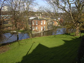
The River Sheaf in Sheffield, South Yorkshire, England, flows northwards, past Dore, through Abbeydale and north of Heeley. It then passes into a culvert, through which it flows under the centre of Sheffield before joining the River Don. This lower section of the River Sheaf, together with the Don between the Blonk Street and Lady's Bridges, formed two sides of the boundary of Sheffield Castle.

<span class="mw-page-title-main">Porter Brook</span> River in Sheffield, South Yorkshire, England

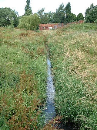
The Porter Brook is a river which flows through the City of Sheffield, England, descending over 1,000 feet (300 m) from its source on Burbage Moor to the west of the city to its mouth where it joins the River Sheaf in a culvert beneath Sheffield railway station. Like the other rivers in Sheffield, its steep gradient made it ideal for powering water mills and works associated with the metalworking and cutlery industries, and around 20 dams were constructed over the centuries to facilitate this. At its lower end, it is extensively culverted, but parts of it are gradually being restored to open channels, as part of a daylighting scheme for the city.

<span class="mw-page-title-main">River Rother, South Yorkshire</span> River in South Yorkshire, England

The River Rother, a waterway in the northern midlands of England, gives its name to the town of Rotherham and to the Rother Valley parliamentary constituency. It rises in Pilsley in Derbyshire and flows in a generally northwards direction through the centre of Chesterfield, where it feeds the Chesterfield Canal, and on through the Rother Valley Country Park and several districts of Sheffield before joining the River Don at Rotherham in Yorkshire. Historically, it powered mills, mainly corn or flour mills, but most had ceased to operate by the early 20th century, and few of the mill buildings survive.

<span class="mw-page-title-main">River Loxley</span> River in South Yorkshire, England

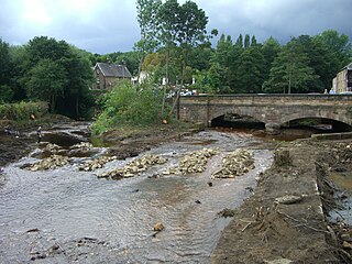
The River Loxley is a river in the City of Sheffield, South Yorkshire, England. Its source is a series of streams which rise some 10 miles (16 km) to the north-west of Sheffield on Bradfield Moors, flowing through Bradfield Dale to converge at Low Bradfield. It flows easterly through Damflask Reservoir and is joined by Storrs Brook at Storrs, near Stannington, and the River Rivelin at Malin Bridge, before flowing into the River Don at Owlerton, in Hillsborough. The Loxley valley provided the initial course of the Great Sheffield Flood, which happened after the Dale Dyke Dam collapsed shortly before its completion in March 1864.

<span class="mw-page-title-main">River Kent</span> River in Cumbria, England

The River Kent is a short river in the county of Cumbria in England. It originates in hills surrounding Kentmere, and flows for around 20 miles (32 km) into the north of Morecambe Bay. The upper reaches and the western bank of the estuary are located within the boundaries of the Lake District National Park. The river flows in a generally north to south direction, passing through Kentmere, Staveley, Burneside, Kendal and Sedgwick. Near Sedgwick, the river passes through a rock gorge which produces a number of low waterfalls. This section is popular with kayakers as it offers high quality whitewater for several days after rain. The village of Arnside is situated on the east bank of the Kent estuary, just above Morecambe Bay, and a tidal bore known as the Arnside Bore forms in the estuary at this point on high spring tides.

<span class="mw-page-title-main">Little Don River</span> River in South Yorkshire, England

The Little Don River also known as the Porter, is a tributary of the River Don in South Yorkshire, England. Arising on the Langsett Moors in the northern Peak District, the Little Don River feeds the Langsett and Underbank Reservoirs. It runs through the town of Stocksbridge before joining the River Don.

<span class="mw-page-title-main">Blackburn Brook</span> Stream in Sheffield, South Yorkshire, England

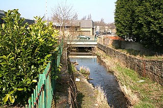
The Blackburn Brook is a stream in Sheffield, South Yorkshire, England which flows through the Blackburn Valley along the M1 and Ecclesfield Road and joins the River Don near the Meadowhall shopping centre. Downstream from the A61 road at Chapeltown the Blackburn Brook is defined as a main river by the Environment Agency, which requires new building development to be at least 26 feet (8 m) from the bank side as a flood defence measure and to allow access to the watercourse for maintenance.

<span class="mw-page-title-main">Peasey Beck</span> Stream in Cumbria, England

Peasey Beck is a 19.6-kilometre-long (12.2 mi) beck flowing through Cumbria, England. It rises on Lambrigg Fell where it is known as the Sparishaw Beck, flows through Killington Reservoir and converges with Stainton Beck to form the River Bela at Milnthorpe. Prior to 1913, it was known as the River Beela throughout its length.

<span class="mw-page-title-main">Stainton Beck</span> Stream in Cumbria, England

Stainton Beck is a watercourse in Cumbria, England. Its upper reaches are known as St. Sunday's Beck.

<span class="mw-page-title-main">Skipton Wood</span> Woodland in North Yorkshire, England

Skipton Wood is a 36-acre (15 ha) wood following the valley of Eller Beck to the north of Skipton behind Skipton Castle in North Yorkshire, England. The wood is owned by Skipton Castle but has been leased to the Woodland Trust.

<span class="mw-page-title-main">Kentmere Reservoir</span> Water storage facility in Cumbria, England

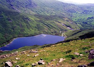
Kentmere Reservoir is a water storage facility situated in the Kentmere valley in the county of Cumbria, England. It is located 10.5 kilometres (6.5 mi) north-northeast of the town of Windermere. The reservoir is fed by the streams which form the headwaters of the River Kent which rise 1.5 kilometres (0.93 mi) to the north in Hall Cove on the southern slopes of a mountainous ridge called High Street, which is named after the nearby Roman road. It is also fed by Lingmell Gill, which drains the large corrie on the western side of Harter Fell beneath the Nan Bield Pass.

<span class="mw-page-title-main">River Drone</span> River in Derbyshire, England

The River Drone is a river which flows south from its source on the Sheffield, South Yorkshire, border. It flows through Dronfield, Unstone and Unstone Green in Derbyshire before merging at Sheepbridge to the north of Chesterfield with the Barlow Brook. Below the junction, it is often referred to as the River Whitting. It then flows south-east till it merges with the River Rother at Brimington Road North (B6050) at Chesterfield. It is one of the three main tributaries of the Rother.

<span class="mw-page-title-main">Bedale Beck</span> Watercourse in North Yorkshire, England

Bedale Beck is a river that flows through the eastern end of Wensleydale and passes through Crakehall, Bedale and Leeming before entering the River Swale at a point between Morton-on-Swale and Gatenby. Between source and mouth its length is 25.7 miles (41 km).

<span class="mw-page-title-main">Skipton Golf Club</span>

Skipton Golf Club is a golf club located within the English county of North Yorkshire. Founded within 1893, the club was originally located a short distance away in the village of Gargrave before moving to its present site just outside the market town of Skipton in 1896.

<span class="mw-page-title-main">Pickering Beck</span> River in North Yorkshire, England

Pickering Beck is a river that runs for over 18 miles (29 km) from its source in the North York Moors National Park through the town of Pickering and on to its confluence with Costa Beck at Kirby Misperton. It is a meandering river that is fed by numerous named and unnamed becks and streams which flow over sandstone and limestone beds and an alluvia of sand, clay silt and gravel. The beck is known for flooding and in recent times has been a beneficiary of funding and experimental flood protection schemes.

<span class="mw-page-title-main">Walverden Water</span> River in Lancashire, England

Walverden Water is a minor river in Lancashire, England. It is approximately 2.6 miles (4.2 km) long and has a catchment area of 5.04 square miles (1,304.23 ha).

<span class="mw-page-title-main">Wyke Beck</span> Stream in West Yorkshire, England

Wyke Beck is a stream that runs from Roundhay Park to the River Aire in east Leeds, West Yorkshire, England. Described as an Urban Beck, the stream flows through housing estates and then an industrial landscape in its lower reaches. Wyke Beck has been prone to flooding so often, that remediation of its course and flood storage schemes have been initiated by Leeds City Council.

<span class="mw-page-title-main">Holgate Beck</span> River in York, England

Holgate Beck is a small watercourse that flows north-eastwards through Holgate across the west side of the City of York, England. Primarily flowing through Holgate, from which it derives its name, the beck drains a large part of Askham Bog and Hob Moor, then running underneath the various lines near York railway station. It empties into the River Ouse at Water End, being one of five main tributaries for the River Ouse in York, and consequently added to the flooding in the river and immediate environs. To counter this, some flood diversionary schemes have been implemented near to Askham Bog and Hob Moor.

References

  1. 1 2 3 4 5 Ordnance Survey, 1:25,000 and 1:2,500 maps
  2. Historic England. "Tarn Moor Bridge (1157603)". National Heritage List for England . Retrieved 26 September 2014.
  3. "Welcome to Skipton Golf Club". Archived from the original on 8 August 2020. Retrieved 26 September 2014.
  4. "Skipton Woods". Skipton Castle. Archived from the original on 17 June 2018. Retrieved 26 September 2014.
  5. Rowley 1983, p. 75.
  6. Dawson 2012, p. 280.
  7. Ordnance Survey, 1:500 map, 1891
  8. Rowley 1983, p. 79.
  9. "Welcome to High Corn Mill". Archived from the original on 13 August 2020. Retrieved 26 September 2014.
  10. Historic England. "High Corn Mill (1316983)". National Heritage List for England . Retrieved 26 September 2014.
  11. Historic England. "Eller Beck Bridge (1131849)". National Heritage List for England . Retrieved 26 September 2014.
  12. Ordnance Survey, 1:1056 Map, 1852, available here
  13. Dawson 2012, p. 279.
  14. Ordnance Survey, 1:2,500 map, 1969 and 1979
  15. Historic England. "Fire Street, Coach Street (1316946)". National Heritage List for England . Retrieved 26 September 2014.
  16. "Eller Beck at Skipton Morrisons". River Levels. Archived from the original on 28 September 2020. Retrieved 27 September 2014.
  17. Environment Agency 2014, p. 2.
  18. Anon (21 January 2014). "Permission sought for flood storage reservoir at Eller Beck, Skipton". Craven Herald and Pioneer. Archived from the original on 2 January 2021. Retrieved 26 September 2014.
  19. Environment Agency 2014, p. 6.
  20. Environment Agency 2014, pp. 32–33.
  21. Environment Agency 2014, p. 17.
  22. Environment Agency 2014, p. 13.
  23. Arup 2013, pp. 8–9.
  24. Thompson, Stuart (30 October 2014). "Cash gap holds up flood scheme". Craven Herald. Archived from the original on 2 January 2021. Retrieved 22 November 2014.
  25. Tate, Lesley (5 February 2015). "Skipton's £13.8 million flood scheme to get under way". Craven Herald and Pioneer. Archived from the original on 2 January 2021. Retrieved 23 November 2015.
  26. White, Clive (4 June 2015). "Skipton Flood Defence Work Starts". Craven Herald and Pioneer. Archived from the original on 2 January 2021. Retrieved 23 November 2015.
  27. White, Clive (5 August 2016). "Top award for Skipton flood defences". Telegraph and Argus. Archived from the original on 31 October 2018. Retrieved 17 May 2017.
  28. Tate, Lesley (5 January 2017). "Defence work in Skipton is on schedule". Craven Herald. Archived from the original on 30 October 2018. Retrieved 17 May 2017.
  29. Mitchinson, James, ed. (12 October 2018). "Flood defences release land for homes and jobs". The Yorkshire Post. p. 2. ISSN   0963-1496.
  30. "Glossary (see Biological quality element; Chemical status; and Ecological status)". Catchment Data Explorer. Environment Agency. 17 February 2016. Retrieved 17 May 2017.
  31. "Eller Beck from Source to Haw Beck". Catchment Data Explorer. Environment Agency. Retrieved 11 April 2021.
  32. "Haw Beck from Source to Eller beck". Catchment Data Explorer. Environment Agency. Retrieved 11 April 2021.
  33. "Eller Beck from Haw Beck to River Aire". Catchment Data Explorer. Environment Agency. Retrieved 11 April 2021.
  34. "Environment Agency - Catchment Data Explorer: Eller Beck from Source to Haw Beck". environment.data.gov.uk. Retrieved 11 April 2021.

Commons-logo.svg Media related to Eller Beck, Craven at Wikimedia Commons

53°56′49″N2°01′32″W / 53.94703°N 2.02565°W / 53.94703; -2.02565