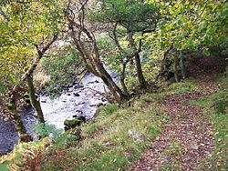
Malham Beck is a stream some 1.2 miles (2 km) long, running southwards through the valley beneath Malham Cove in the Yorkshire Dales, England. It originates in a cave beneath Malham Cove, and flows through Malham before joining Gordale Beck to become the River Aire just south of the village.

Swaledale is a valley in North Yorkshire, England. It is one of the Yorkshire Dales, which are part of the Pennines, and within the Yorkshire Dales National Park. It is named after the River Swale, which runs through it. Swaledale is the most northerly of the major dales.

Arkengarthdale is a dale, or valley, on the east side of the Pennines in North Yorkshire, England. Running roughly north-west to south-east, it is the valley of the Arkle Beck, and is the northernmost of the Yorkshire Dales. It is a subsidiary dale to Swaledale, which it joins at Reeth. The history of the dale, its people, and farming, lead mining, and local crafts is displayed and documented in the Swaledale Museum in Reeth.

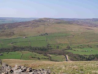
Fremington Edge is a 3-mile (5 km) long wall of crags and scree slopes that is situated to the north of the village of Reeth in Swaledale in the Yorkshire Dales National Park, England. Fremington Edge forms the south-eastern edge of Arkengarthdale, extending to the point where the dale meets Swaledale. Throughout its full length the Edge stays above the height of 1,300 feet (400 m) and reaches a highest point of 1,552 feet (473 m) at the northern end of the escarpment.

East Gill Force is a waterfall in Swaledale, 330 yards (300 m) east of the hamlet of Keld, in the Yorkshire Dales National Park, North Yorkshire, England. The falls are located on East Gill at grid reference NY896012, just before its confluence with the River Swale at the point where the Pennine Way and the Coast to Coast Walk intersect. The falls are a popular spot for visitors, not just long-distance walkers but also families and picnickers because of the proximity of the road. East Gill Force has two main torrents: the upper falls have an impressive 15-foot (4.5 m) drop whilst the lower section is a series of stepped cascades that fall 9.8 feet (3 m) as East Gill enters the River Swale.

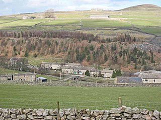
Marrick is a village and civil parish in the Richmondshire district of North Yorkshire, England, situated in lower Swaledale in the Yorkshire Dales National Park, the village is approximately 9 miles (14 km) west of Richmond. The parish of Marrick also includes the hamlets of Hurst and Washfold, according to the UK 2011 Census, the population of the parish was 148.
Calver Hill is a fell in the Yorkshire Dales National Park in North Yorkshire, England. It is composed of limestone and is situated at grid reference NZ012003, near where the valleys of Swaledale and Arkengarthdale meet, the village of Reeth is located on its lower south-eastern slopes, it reaches an altitude of 487 metres (1,598 ft) and is a distinguished feature in mid Swaledale. Calver Hill is an area of grouse shooting and the fell is dotted with grouse butts. Most of the drainage from the fell goes north and easterly to join the Arkle Beck in lower Arkengarthdale which eventually joins the River Swale just south of Reeth.

Cotterdale is a small side dale and hamlet on the north side of Wensleydale in North Yorkshire, England. The dale lies to the west of Great Shunner Fell. It is drained by East Gill and West Gill, which between them have nine waterfalls. They join to form Cotterdale Beck, which flows over three more waterfalls, including Cotter Force, below which the beck joins the River Ure.

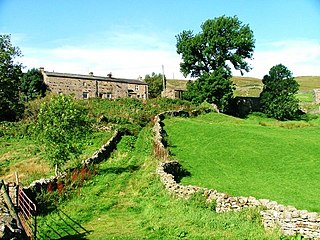
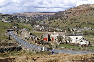
Satron is a hamlet in Swaledale, North Yorkshire, England. It lies 0.6 miles (1 km) south west of Gunnerside on the opposite bank of the River Swale. It is in the civil parish of Muker, but used to be in the ancient parish of Grinton.
The River Wenning is a tributary of the River Lune, flowing through North Yorkshire and Lancashire. The name derives from the Old English Wann, meaning dark river.
Angram is a hamlet in the Yorkshire Dales in the Richmondshire district of North Yorkshire, England. It is situated near to Keld to the north and Thwaite to the south. Angram forms part of the civil parish of Muker.
Whaw is a hamlet in Arkengarthdale in North Yorkshire, England. It is one of few settlements in the dale and is one of the smallest. Its name derives from the Old Norse of Kvi and Hagi, which means the enclosure of the sheep. It is about 2 miles (3.2 km) north of Langthwaite and 5 miles (8 km) north west of Reeth. The adjacent Arkle Beck Meadows form a Site of Special Scientific Interest.
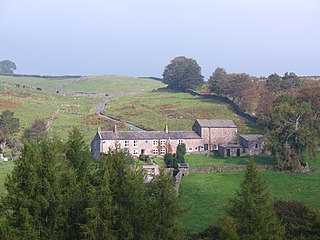
Arkle Town is a hamlet in Arkengarthdale in the Richmondshire district of North Yorkshire, England. It is situated 0.4 miles (0.64 km) to the south of Langthwaite and 2.7 miles (4.3 km) north-west of Reeth.
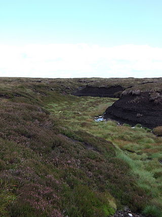
Arkengarthdale Gunnerside and Reeth Moors is a 7,634.72 hectares biological Site of Special Scientific Interest (SSSI) in the Yorkshire Dales between Arkengarthdale and Swaledale. The SSSI was first notified in June 1998 and is due to the blanket bog, heather moorland, and breeding bird populations such as merlin and golden plover.
Arkle Beck Meadows, Whaw is a 8.4 hectares biological Site of Special Scientific Interest (SSSI) at Whaw in Arkengarthdale in the Yorkshire Dales. The SSSI was first notified in 1986 and is due to the hay meadows which are traditionally managed by hay cropping and grazing.

Kettlewell with Starbotton is a civil parish in the Craven district of North Yorkshire, England.
Eskeleth is a hamlet in Arkengarthdale in North Yorkshire, England. It is in the Yorkshire Dales National Park. Eskeleth sits 4 miles (6.4 km) from the village of Reeth.
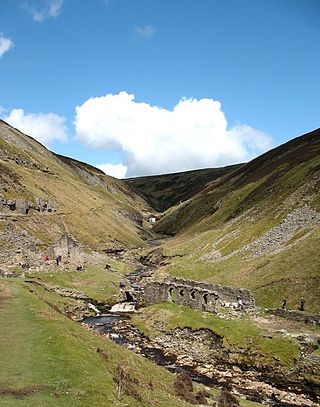
Gunnerside Gill is a small valley in the Yorkshire Dales, England, which branches off Swaledale into moorland to the north of Gunnerside.

Ling Gill is a gill in the Yorkshire Dales in North Yorkshire, England. Cam Beck, a tributary of the River Ribble, flows through the gill.

Leyburn Old Glebe Nature Reserve is a nature reserve and Site of Special Scientific Interest (SSSI) managed by the Yorkshire Wildlife Trust. It is about 440 yards (400 m) east of the village of Wensley and 0.6 miles (1 km) southwest of Leyburn. The site is a traditionally-managed 3 hectare hay meadow on a south-facing slope, overlooking the River Ure. It is one of the best preserved unimproved meadows in the Yorkshire Dales. Each year, after the flowers have set seed, an autumn hay cut and grazing by a limited number of sheep are essential management to prevent the area becoming overgrown.