Tong is a ward within the City of Bradford Metropolitan District Council, West Yorkshire, England, named after Tong village which is its oldest settlement. The population at the 2011 Census was 20,608.

The River Cole is a 25 miles (40 km) river in the English Midlands. It rises on the lower slopes of Forhill, one of the south-western ramparts of the Birmingham Plateau, at Red Hill and flows south before flowing largely north-east across the plateau to enter the River Blythe below Coleshill, near Ladywalk, shortly before the Blythe meets the Tame. This then joins the Trent, whose waters reach the North Sea via the Humber Estuary. Its source is very near the main watershed of Midland England: tributaries are few and very short except in the lower reaches, so the Cole is only a small stream.

Farnley is a district in Leeds, West Yorkshire, England, 2 miles (3.2 km) west of Leeds city centre, between Wortley, Bramley and the countryside around Pudsey and Gildersome, in the LS12 Leeds postcode area. It is part of the Leeds City Ward Farnley and Wortley with a population of 24,213 according to the 2011 Census. New Farnley is a nearby commuter village.

The Hogsmill River in Surrey and Greater London, England is a small chalk stream tributary of the River Thames. It rises in Ewell and flows into the Thames at Kingston upon Thames on the lowest non-tidal reach, that above Teddington Lock.

The River Darwen runs through Darwen and Blackburn in Lancashire, England, eventually joining the River Ribble at Walton le Dale south of Preston on its way to the Ribble Estuary.

The River Calder is a major tributary of the River Ribble in Lancashire, England, and is around 20 miles (32 km) in length.

The River Roddlesworth is a river in Lancashire, England, a tributary of the River Darwen.

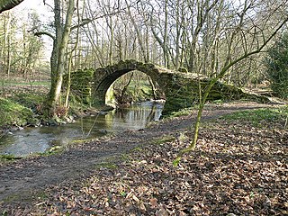
Fulneck Moravian Settlement is a village in Pudsey in the City of Leeds metropolitan borough, West Yorkshire, England. The village lies on a hillside overlooking a deep valley. Pudsey Beck flows along the bottom of the valley.

The Lea Valley Walk is a 50-mile (80 km) long-distance path located between Leagrave, the source of the River Lea near Luton, and the Thames, at Limehouse Basin, Limehouse, east London. From its source much of the walk is rural. At Hertford the path follows the towpath of the River Lee Navigation, and it becomes increasingly urbanised as it approaches London. The walk was opened in 1993 and is waymarked throughout using a swan logo.

The Leeds Country Way is a circular long-distance footpath of 62 miles (99 km) around Leeds, West Yorkshire, England. It is never more than 7 miles (11 km) from City Square, Leeds, but is mainly rural with extensive views in the outlying areas of the Leeds metropolitan district. It follows public Rights of Way including footpaths, bridleways and minor lanes, with a few short sections along roads.

Tong or Tong Village is a village and former civil parish in the City of Bradford metropolitan district, West Yorkshire, England. It is a historic village, and gives its name to the larger electoral ward of Tong.

The Eller Beck is a small river in North Yorkshire, England, that flows through the town of Skipton and is a tributary of the River Aire. Its channel was heavily modified to supply water to mills in the 18th and 19th centuries, and although all the mills have closed, the water now supplies power to the National Grid, generated by a turbine at High Corn Mill. The beck flows through several underground culverts in Skipton that contribute to the flood risk. To alleviate flooding in Skipton town centre, a scheme involving two flood water storage reservoirs was designed and eventually completed in 2017.

Tyersal Beck is a watercourse in West Yorkshire, England, named after the village of Tyersal in whose vicinity it runs.

Post Hill is a designated Leeds Nature Area on the western end of Farnley, and partly in Pudsey. It is situated mostly east of Pudsey Beck and Farnley Beck, between Wood Lane in the north and Troydale Lane in the south, and forms part of the West Leeds Country Park.

Oldcotes Dyke is the name of the final section of a river system that drains parts of north Nottinghamshire and the Metropolitan Borough of Rotherham in South Yorkshire, England. Historically, it has supported milling, with seven water mills drawing their power from its water, and ran through the grounds of the Cistercian Roche Abbey. It is a tributary of the River Ryton.

Holme Beck is a watercourse in the Tong ward of the City of Bradford, West Yorkshire, England. It drains a shallow valley east of the watershed between Bradford and Leeds. Holme Beck begins in the village with no evidence of any continuation on the other side of the canal or motorway. Holme Beck is the main carrier for village drainage, it runs beneath the West Coast Main Line and then through the large marsh area of Holme Moss before joining the River Bela.
Pudsey is a ward in the metropolitan borough of the City of Leeds, West Yorkshire, England. It contains 47 listed buildings that are recorded in the National Heritage List for England. Of these, one is listed at Grade I, the highest of the three grades, two are at Grade II*, the middle grade, and the others are at Grade II, the lowest grade. The parish contains the town of Pudsey, including the area of Swinnow, and the countryside to the southwest, including the village of Tyersal. It also contains the Fulneck Moravian Settlement, many of whose buildings are listed. Most of the other listed buildings are houses, cottages, and associated structures, farmhouses and farm buildings, a milestone, public houses, some of which have been converted for other uses, former schools, churches, a bank, and a war memorial.

Wyke Beck is a stream that runs from Roundhay Park to the River Aire in east Leeds, West Yorkshire, England. Described as an Urban Beck, the stream flows through housing estates and then an industrial landscape in its lower reaches. Wyke Beck has been prone to flooding so often, that remediation of its course and flood storage schemes have been initiated by Leeds City Council.
Oak Beck is a watercourse that flows eastwards across the northern part of Harrogate in North Yorkshire, England. The beck flows through a broad V-shaped valley, before emptying into the River Nidd at Bilton, just upstream from the Nidd Gorge Viaduct. Water from Oak Beck has been used as a water supply for Harrogate and also for industrial purposes further downstream.