
The River Aire is a major river in Yorkshire, England, 92 miles (148 km) in length. Part of the river below Leeds is canalised, and is known as the Aire and Calder Navigation.

Airedale is a valley, or dale, in North Yorkshire and West Yorkshire, England. It is named after the River Aire, which flows through it. The upper valley, from Malham Cove to Airton, is known as Malhamdale, named after the village of Malham. At Airton the valley widens and becomes Airedale proper. The river flows past Skipton on to Keighley, Bingley, Shipley, and Leeds.

Cookridge is a suburb of north-west Leeds, West Yorkshire, England, north of the Leeds Outer Ring Road. In 1715 Ralph Thoresby described it as a village four miles from Leeds and three from Otley, dating from 1540.
Weetwood is an area between Headingley and Meanwood in north-west Leeds, West Yorkshire, England. It is bounded on the north by the A6120, on the west by the A660, on the east by Meanwood Beck and to the south by Hollin Lane. Weetwood Lane runs north and south through it.

Meanwood is a suburb and former village in north-west Leeds, West Yorkshire, England.

Woodhouse is a largely residential area just north of the city centre of Leeds and close to the University of Leeds. The area considered as Woodhouse is partly in the Little London and Woodhouse ward and partly in the Headingley & Hyde Park ward of City of Leeds metropolitan district.

Adel is a suburb of Leeds, West Yorkshire, England. To its immediate south is Weetwood, to the west are Cookridge and Holt Park, to the east are Alwoodley and Moortown, and to the north are Bramhope, Arthington and Eccup.

Miles Hill is a district in Leeds. It is about 1.5 miles (2 km) north of Leeds city centre, West Yorkshire, England and is situated between Meanwood and Chapel Allerton next to Beck Hill. The district is located in the Chapel Allerton ward of Leeds Metropolitan Council.

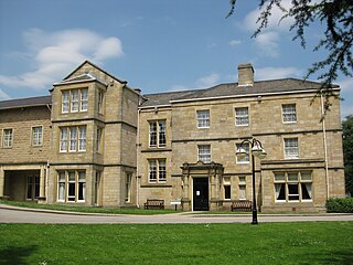
Bodington Hall was the largest hall of residence of the University of Leeds, in Leeds, England. It was opened in 1961 and closed in 2013. The site still contains the university's main playing fields. Known as Bod within the university, it was located between Lawnswood and Adel, approximately 4 miles north of the main campus. Bodington was used mainly to house first year undergraduate students. Out of term, it was used for conferences and sporting activities such as WorldNET, the Internet Football Association's annual tournament, and from 1994 to 2012 it was the venue for the International Medieval Congress (IMC).

Holbeck is an inner city area of Leeds, West Yorkshire, England. It begins on the southern edge of Leeds city centre and mainly lies in the LS11 postcode district. The M1 and M621 motorways used to end/begin in Holbeck. Now the M621 is the only motorway that passes through the area since the end of the M1 moved to Hook Moor near Aberford. Since large parts of Holbeck have been vacated in preparation for the regeneration of the area, the district has in large parts suffered from a population exodus. Holbeck had a population of 5,505 in 2011. The district currently falls within the Beeston and Holbeck ward of Leeds City Council.

Killingbeck is a district of east Leeds, West Yorkshire, England named after the Killingbeck family, historic local landowners, and is situated between Seacroft to the north, Cross Gates and Whitkirk to the east, Gipton to the west, Halton Moor to the south, Halton to the south-east and Osmondthorpe to the south-west.

This is a list of halls of residence both on and off campus at the University of Leeds in Leeds, England.

The Leeds Country Way is a circular long-distance footpath of 62 miles (99 km) around Leeds, West Yorkshire, England. It is never more than 7 miles (11 km) from City Square, Leeds, but is mainly rural with extensive views in the outlying areas of the Leeds metropolitan district. It follows public Rights of Way including footpaths, bridleways and minor lanes, with a few short sections along roads.
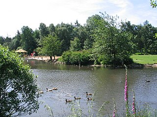
Golden Acre Park is a public park in Bramhope, Leeds, West Yorkshire, England, administered by Leeds City Council. It is on the A660 Otley Road and covers an area of 179 acres (72 ha).

The Meanwood Valley Trail is a waymarked footpath and the title of an annual (March/April) footrace that takes place on parts of the trail in Leeds, West Yorkshire, England. It runs for a distance of 7 miles (11 km) from the statue of Henry Rowland Marsden, 1878, on Woodhouse Moor, close to the University of Leeds, through Headingley, Meanwood and Adel to Breary Marsh, Golden Acre Park, where it meets the Leeds Country Way. For most of its route it is the official Leeds link to the Dales Way. Along the way are signs giving information about the local wildlife.

Knowsthorpe, Knostrop or Knostropp is an area of Leeds, West Yorkshire, England, on the River Aire. The spelling "Knostrop" is predominantly used for the large water treatment works in the area. Atkinson Grimshaw painted Knostrop Cut, Leeds, Sunday Night, 1893. The area falls within Temple Newsam ward of Leeds City Council.

Meanwood Valley Urban Farm is a city farm established in 1980 in Meanwood, Leeds, England, which has animals and crops and an environmentally friendly visitors centre. The farm is on Meanwood Beck and occupies 24 acres (97,000 m2). The main entrance is on Sugarwell Road.
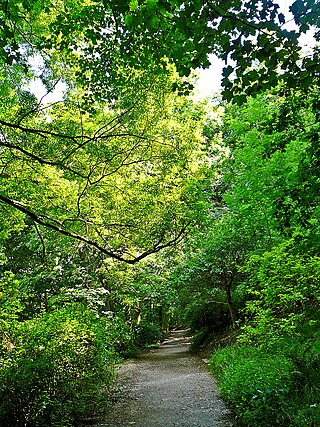
Woodhouse Ridge is a strip of woodland on the South West hillside of the Meanwood valley in urban area of Leeds, West Yorkshire, England. Locally known as 'The Ridge', the area is notable as a significant area of mature woodland in an otherwise highly developed urban area. The woods are centred at grid reference 53.820061, -1.560144 and are enclosed by Meanwood Road to the east and by Headingley to the north and Woodhouse, Leeds to the South.

Wyke Beck is a stream that runs from Roundhay Park to the River Aire in east Leeds, West Yorkshire, England. Described as an Urban Beck, the stream flows through housing estates and then an industrial landscape in its lower reaches. Wyke Beck has been prone to flooding so often, that remediation of its course and flood storage schemes have been initiated by Leeds City Council.


