River Nidd

Last updated

River Nidd
Knaresborough Viaduct from River Nidd.jpg
Railway Viaduct over the River Nidd in Knaresborough
54°10′23″N1°59′53″W / 54.17306°N 1.99806°W / 54.17306; -1.99806
Yorkshire and the Humber districts 2011 map.svg
Red pog.svg
England relief location map.jpg
Red pog.svg
EtymologyProbably a Celtic word meaning "bright, brilliant, shining"
Location
Country England
Physical characteristics
Source 
  locationNidd Head Spring, 1.3 km north of the summit of Great Whernside
  elevation595 metres (1,952 ft)
Mouth  
  location
River Ouse, Nun Monkton
  coordinates
54°0′51″N1°13′8″W / 54.01417°N 1.21889°W / 54.01417; -1.21889
  elevation
13 metres (43 ft)
Length94.45 kilometres (58.69 mi)
Basin size516 square kilometres (199 sq mi)
Basin features
River system SwaleOuse

The River Nidd is a tributary of the River Ouse in the English county of North Yorkshire. It rises in Nidderdale at Nidd Head Spring on the slopes of Great Whernside. In its first few miles it has been dammed three times, creating Angram Reservoir, Scar House Reservoir and Gouthwaite Reservoir, which attract a total of around 150,000 visitors a year. [1] It joins the River Ouse at Nun Monkton.

Contents

The upper river valley, Nidderdale, was designated as an Area of Outstanding Natural Beauty in 1994. [2]

The Yorkshire Dales Rivers Trust has a remit to conserve the ecological condition of the River Nidd from its headwaters to the Humber estuary.

Course

The Nidd rises in Nidderdale at Nidd Head Spring on the slopes of Great Whernside in the Yorkshire Dales. It flows east into Angram and Scar House reservoirs before turning south just downstream of Newhouses. In dry conditions the river disappears underground into the sinkhole known as Manchester Hole. If Scar House reservoir overflows, water flows past Manchester Hole to Goyden Pot, another sinkhole. In severe floods, the river flows past Goyden Pot down the valley. The water sinking into the Nidderdale caves reappears at the rising Nidd Head to the south of the village of Lofthouse.

Below Lofthouse the river is joined by How Stean Beck, and turns south-south-east towards Ramsgill before flowing into Gouthwaite Reservoir. Continuing on the same heading, the first major settlement is reached at Pateley Bridge. Turning more south-easterly, it flows past Glasshouses and Summerbridge, where it turns south again past Dacre Banks. Passing by Darley, the river turns east before reaching Birstwith, where it flows south-east to Hampsthwaite. A series of large bends in the river take the flow north, east and then south, and east again, to enter Nidd Gorge.

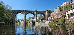
Below the gorge, the river meanders south-east through the town of Knaresborough, heading north and looping south again as it enters flatter terrain. Near Little Ribston it meanders south-easterly and easterly, crossing underneath the A1 and the A1(M) near the small village of Cowthorpe. The river continues meandering past Cattal north-easterly towards Moor Monkton, towards its junction with the River Ouse at Nun Monkton.

Water levels

Monitoring Station [3] Station ElevationLow water levelHigh water levelRecord high level
Gouthwaite Reservoir122.53 m (402.0 ft)0.08 m (0.26 ft)1.10 m (3.6 ft)3.40 m (11.2 ft)
Pateley Bridge113.06 m (370.9 ft)0.14 m (0.46 ft)2.5 m (8.2 ft)3.73 m (12.2 ft)
Birstwith70.9 m (233 ft)0.11 m (0.36 ft)1.5 m (4.9 ft)3.66 m (12.0 ft)
Knaresborough36.86 m (120.9 ft)0.42 m (1.4 ft)1.3 m (4.3 ft)2.16 m (7.1 ft)
Hunsingore18.14 m (59.5 ft)0.08 m (0.26 ft)0.85 m (2.8 ft)2.92 m (9.6 ft)
Skip Bridge7.58 m (24.9 ft)0.22 m (0.72 ft)2.36 m (7.7 ft)5.06 m (16.6 ft)

Reservoirs

The two most northerly reservoirs on the course of the river were built to provide water to the Bradford area in the early 1900s by way of the Nidd Aqueduct. As of 2017, they are maintained by Yorkshire Water. [4]

Angram Reservoir

The reservoir takes its name from Angram, a settlement in the township of Stonebeck Up, submerged when the reservoir was built. Completed in 1919 with a dam height of 61 metres (200 ft) covering 34 hectares with a volume of 1,041 million gallons and a depth of 33.4 metres (110 ft).

Scar House Reservoir

A temporary village was built at Scar House to house the workers building the reservoirs and some remains can still be seen. The old Village Hall was moved to Darley, where it now serves as the local Village Hall. The dam at Scar House was completed in 1936. The dam height is 71 m (233 ft) with the reservoir covering area 70 hectares and a depth of36.3 metres (119 ft) giving a volume of 2,200 million gallons. The reservoir is fed almost exclusively from the Angram dam.

Gouthwaite Reservoir

Gouthwaite reservoir is designated a Site for Special Scientific Interest. [5] It provides a compensation release for the river. [6] It covers an area of 312 acres (126 ha). [7]

The Nidd can overflow the reservoirs, flooding the caves in the valley. [8] [9] In such cases the river overflows into the normally dry river bed past Lofthouse through to Gouthwaite Reservoir.

Geology

The head of the river is located on moorland and the river character is affected by the run-off levels from the three reservoirs. The upper valley is primarily millstone grit with fluvioglacial deposits. The overlying soil is prone to water-logging due to its slow permeability, being composed of loamy soils on top of clay with peat on the top layer. Around Lofthouse there are outcrops of Upper Yoredale limestone, which is more permeable than millstone grit and has created the Nidderdale Caves, where the river flows underground.

Lower down on the flood plain, the nature of the underlying ground is Magnesian Limestone over alluvium and terrace drift deposits. On top of this is a combination of slowly permeable and well drained fine loam over clay. [10] [11]

Where the river passes through the Nidd Gorge, Carboniferous (Namurian) and Upper Permian rock is exposed. [12]

Etymology

The etymology of the name remains unknown but the name is either Celtic or Pre-Celtic (as with most rivers in Western Europe). A derivation from Celtic meaning brilliant or shining has been suggested (as in Old Irish níamda), [13] as has a link to the older Indo-European root *-nedi, simply meaning river. [14] [15] [16] [17]

The Nidd likely shares this etymology with the river and town of Neath (Welsh Nedd) in South Wales and the town of Stratton in Cornwall (originally named Strat-Neth), and with many other rivers across Europe, such as the Nete in Belgium, the Nied in France, the Nethe, Nidda and Nidder in Germany, and the Nida in Poland. [18] [16] [19] [20]

Leisure

Along the river valley can be found the Nidderdale Museum, which is located in Pateley Bridge, and features sections about the traditional agriculture, industries, religion, transport and costume of Nidderdale.

Lower down the river is the town of Knaresborough, which is home to Knaresborough Castle and Knaresborough Museum.

There are many way-marked walking routes throughout the river valley, including the Nidderdale Way, a 55-mile circular walk whose usual starting point is Ripley.

Lists

Tributaries

Settlements

Crossings

Sources

Ordnance Survey Maps

Related Research Articles

<span class="mw-page-title-main">Yorkshire Dales</span> Upland area of the Pennines in Northern England

The Yorkshire Dales are a series of valleys, or dales, in the Pennines, an upland range in England. They are mostly located in the ceremonial county of North Yorkshire, but extend into Cumbria and Lancashire; they are entirely within the historic boundaries of Yorkshire. The majority of the dales are within the Yorkshire Dales National Park, created in 1954. The exception is the area around Nidderdale, which forms the separate Nidderdale Area of Outstanding Natural Beauty.

<span class="mw-page-title-main">Skipton and Ripon (UK Parliament constituency)</span> Parliamentary constituency in the United Kingdom, 1983 onwards

Skipton and Ripon is a constituency in North Yorkshire represented in the House of Commons of the UK Parliament since 2010 by Julian Smith, a Conservative.

<span class="mw-page-title-main">Great Whernside</span> Mountain in the Yorkshire Dales, England

Great Whernside is a fell in the Yorkshire Dales, England, not to be confused with Whernside, some 17 miles (27 km) to the west. Its summit is the highest point of the eastern flank of Wharfedale above Kettlewell. Great Whernside forms the watershed between Wharfedale and Nidderdale, and is on the boundary between the Yorkshire Dales National Park and Nidderdale Area of Outstanding Natural Beauty. The River Nidd rises on the eastern slopes of Great Whernside, above Angram Reservoir.

<span class="mw-page-title-main">Nidderdale</span> Valley in Yorkshire, England

Nidderdale, historically also known as Netherdale, is one of the Yorkshire Dales in North Yorkshire, England. It is the upper valley of the River Nidd, which flows south underground and then along the dale, forming several reservoirs including the Gouthwaite Reservoir, before turning east and eventually joining the River Ouse.

<span class="mw-page-title-main">Nidderdale National Landscape</span> Area of Outstanding Natural Beauty in England

The Nidderdale National Landscape is an Area of Outstanding Natural Beauty in North Yorkshire, England, bordering the Yorkshire Dales National Park to the east and south. It comprises most of Nidderdale itself, part of lower Wharfedale, the Washburn valley and part of lower Wensleydale, including Jervaulx Abbey and the side valleys west of the River Ure. It covers a total area of 233 square miles (600 km2). The highest point in the Nidderdale AONB is Great Whernside, 704 metres (2,310 ft) above sea level, on the border with the Yorkshire Dales National Park.

<span class="mw-page-title-main">Angram Reservoir</span> Reservoir in North Yorkshire, England

Angram Reservoir is the first of three reservoirs on the River Nidd in Upper Nidderdale, North Yorkshire, England, the others being Scar House Reservoir and finally the compensation reservoir Gouthwaite Reservoir. It is located at OS map reference SE040759. Between them they attract around 150,000 visitors a year.

<span class="mw-page-title-main">Scar House Reservoir</span> Reservoir in North Yorkshire, England

Scar House Reservoir is the second of the three reservoirs in Upper Nidderdale, North Yorkshire, England, the others are Angram Reservoir and Gouthwaite Reservoir. Between them they attract around 150,000 visitors a year.

<span class="mw-page-title-main">Nidd Gorge</span> River gorge in North Yorkshire, England

Nidd Gorge makes up a section of the River Nidd in North Yorkshire, England, in which the river enters a deep ravine with sheer tree-covered valley sides. The river as a whole flows from its source near Great Whernside in Nidderdale, to its confluence with the River Ouse near Nun Monkton. Nidd Gorge makes up approximately 3 miles (4.8 km) of the entire length of the river, and stretches from the now defunct Nidd viaduct at Bilton in Harrogate to Grimbald Bridge, just south of Knaresborough.

<span class="mw-page-title-main">Nidd Valley Light Railway</span> Disused railway in Yorkshire, England

Nidd Valley Light Railway was a light railway in upper Nidderdale in the West Riding of Yorkshire, England. It was owned by Bradford Corporation Waterworks Department and the corporation also operated its public passenger services. Power & Traction Ltd of London obtained a Light Railway Order for the 6.5-mile (10.5 km) railway from Pateley Bridge to Lofthouse in 1900, but these powers were taken over by Bradford Corporation. A contract to build Angram Reservoir was awarded to John Best & Son in 1903, and he also won the contract to build the public railway and a 6.5-mile (10.5 km) private extension to the reservoir site. This was initially built to 3 ft gauge but was converted to standard gauge by 1907, when the public railway opened. Best had his own locomotives, and Bradford Corporation equipped the public railway with second hand locomotives and carriages from the Metropolitan Railway.

The Six Dales Trail is a long distance footpath in North Yorkshire, England, with a short section in West Yorkshire. It is 38 miles (61 km) long and connects Otley and Middleham.

<span class="mw-page-title-main">Nidd Valley Railway</span> Disused railway line in Yorkshire, England

The Nidd Valley Railway was a 11.5-mile (18.5 km) long single-track branch railway line that ran along the valley of the River Nidd in North Yorkshire, England. Built by the North Eastern Railway, it ran from Ripley Junction, on the Harrogate to Ripon Line, to Pateley Bridge via five intermediate stations, Ripley Valley, Hampsthwaite, Birstwith, Darley, and Dacre.

<span class="mw-page-title-main">Stonebeck Up</span> Civil parish in North Yorkshire, England

Stonebeck Up is a civil parish in Harrogate district, North Yorkshire, England. The only village in the parish is Middlesmoor. The population of the parish in the 2011 census was 119.

The Nidderdale Caves are a series of caves in Upper Nidderdale in North Yorkshire, England. There are two cave systems and most of the caves are in some way linked with one or the other. The smaller system is the Eglin cave system in the valley of How Stean Beck, a tributary of the River Nidd, associated with How Stean Gorge. The larger system is the Goyden cave system under the valley of the River Nidd, which flows east from Scar House Reservoir, then south, and shortly after disappears underground down several sinkholes to reappear at the rising just beyond the village of Lofthouse. Cavers can access several sections of this system via the different entrances.

<span class="mw-page-title-main">Nidderdale Way</span> Long-distance footpath in North Yorkshire, England

The Nidderdale Way is a 55-mile (89 km) circular long distance footpath in Nidderdale in North Yorkshire, England.

<span class="mw-page-title-main">Nidd Aqueduct</span> A freshwater aqueduct in Yorkshire, England

The Nidd Aqueduct is an aqueduct or man-made watercourse in North Yorkshire, England. It feeds water from Angram and Scar House reservoirs in upper Nidderdale, North Yorkshire 32 mi (51 km) to Bradford in West Yorkshire. The aqueduct supplies 21,000,000 imp gal (95,000 m3) of water per day to Chellow Heights water treatment works. The aqueduct and the reservoirs it connects to are all maintained by Yorkshire Water.

<span class="mw-page-title-main">Scotgate Ash Quarry</span> Disused quarry in North Yorkshire, England

Scotgate Ash Quarry or Scot Gate Ash Quarry, was the collective name for extensive quarry workings that were on the northern edge of Pateley Bridge, North Yorkshire, England. When the quarry was last in use, the area was in the West Riding of Yorkshire, and was described as being the largest quarry in West Yorkshire.

<span class="mw-page-title-main">Yorkshire Water Way</span>

The Yorkshire Water Way is a 104-mile (167 km) path that runs from Kettlewell in North Yorkshire to Langsett in South Yorkshire. It was devised by Mark Reid in conjunction with Yorkshire Water (YW) and it passes by over more than 20 reservoirs which are operated by Yorkshire Water.

Wath-in-Nidderdale railway station, was one of two intermediate stations on the Nidd Valley Light Railway, in Wath-in-Nidderdale, Yorkshire, England. The station was opened in September 1907, and closed to passengers in January 1930, however the line remained open until 1936 to transport freight to and from the reservoirs in the Upper Nidd Valley.

Lofthouse-in-Nidderdale railway station was the northernmost regular passenger terminus on the Nidd Valley Light Railway (NVLR), in Lofthouse, then in the West Riding of Yorkshire and now in North Yorkshire, England. The station was built as part of Bradford Corporation's programme of reservoir building in the Upper Nidd Valley. The station opened in 1904 and was closed to passengers in 1930. The station was renamed Lofthouse-in-Nidderdale railway station in 1907 to avoid confusion with Lofthouse and Outwood railway station, also in the West Riding of Yorkshire.

<span class="mw-page-title-main">Oak Beck</span> River in North Yorkshire, England

Oak Beck is a watercourse that flows eastwards across the northern part of Harrogate in North Yorkshire, England. The beck flows through a broad V-shaped valley, before emptying into the River Nidd at Bilton, just upstream from the Nidd Gorge Viaduct. Water from Oak Beck has been used as a water supply for Harrogate and also for industrial purposes further downstream.

References

  1. "Scar House Reservoir". www.yorkshireguides.com. Retrieved 22 June 2017.
  2. "York & North Yorkshire – Wading birds need landowners' help". BBC News. 27 October 2009. Retrieved 22 June 2017.
  3. "River levels" . Retrieved 23 December 2010.
  4. "Walk this way to shed the pounds". yorkshirewater.com. 20 April 2017. Retrieved 22 June 2017.
  5. "Gouthwaite Reservoir" (PDF). naturalengland.org.uk. Retrieved 27 November 2018.
  6. "Multi-million pound plan to improve safety at Gouthwaite reservoir". Harrogate Advertiser. 9 May 2017. Retrieved 27 November 2018.
  7. "Gouthwaite Reservoir". britishlakes.info. Retrieved 27 November 2018.
  8. Wainwright, Martin (16 November 2005). "Pupil, 14, dies in pothole accident during school caving trip". The Guardian. Retrieved 22 June 2017.
  9. "River Nidd – Yorkshire Dales Rivers Trust". Yorkshire Dales Rivers Trust. Retrieved 22 June 2017.
  10. "Geology Upper Valley" (PDF). Retrieved 27 August 2011.
  11. "Geology Lower Valley" (PDF). Retrieved 27 August 2011.
  12. "Knaresborough Gorge Geology" (PDF). Retrieved 27 August 2011.
  13. "eDIL – Irish Language Dictionary". www.dil.ie. Retrieved 7 December 2020.
  14. "Etymology" . Retrieved 27 August 2011.
  15. Owen, Hywel Wyn; Morgan, Richard (2008). Dictionary of the Place-names of Wales. Llandysul: Gomer Press. p. 342.
  16. 1 2 Davies, John; Jenkins, Nigel; Baines, Menna; Lynch, Peredur I., eds. (2008). The Welsh Academy Encyclopedia of Wales. Cardiff: University of Wales Press. p. 603.
  17. "celtpn". www.yorkshiredialect.com. Retrieved 7 December 2020.
  18. Society, Yorkshire Dialect (7 December 1958). "Transactions of the Yorkshire Dialect Society" via Google Books.
  19. Weatherhill, Craig (2009) A Concise Dictionary of Cornish Place-names. Westport, Co. Mayo: Evertype; p. 65
  20. Fergusson, Robert (1868). The River Names of Europe. p. 54.