The Main is the longest tributary of the Rhine. It rises as the White Main in the Fichtel Mountains of northeastern Bavaria and flows west through central Germany for 525 kilometres (326 mi) to meet the Rhine below Rüsselsheim, Hesse. The cities of Mainz and Wiesbaden are close to the confluence.

The Ruhr is a river in western Germany, a right tributary (east-side) of the Rhine.

The Neckar is a 362-kilometre-long (225 mi) river in Germany, mainly flowing through the southwestern state of Baden-Württemberg, with a short section through Hesse. The Neckar is a major right tributary of the Rhine. Rising in the Schwarzwald-Baar-Kreis near Schwenningen in the Schwenninger Moos conservation area at a height of 706 m (2,316 ft) above sea level, it passes through Rottweil, Rottenburg am Neckar, Kilchberg, Tübingen, Wernau, Nürtingen, Plochingen, Esslingen, Stuttgart, Ludwigsburg, Marbach, Heilbronn and Heidelberg, before discharging on average 145 m3/s (5,100 cu ft/s) of water into the Rhine at Mannheim, at 95 m (312 ft) above sea level, making the Neckar its 4th largest tributary, and the 10th largest river in Germany. Since 1968, the Neckar has been navigable for cargo ships via 27 locks for about 200 kilometres (120 mi) upstream from Mannheim to the river port of Plochingen, at the confluence with the Fils.

The Aller is a 215-kilometre-long (134 mi) river in the states of Saxony-Anhalt and Lower Saxony in Germany. It is a right-hand, and hence eastern, tributary of the Weser and is also its largest tributary. Its last 117 kilometres (73 mi) form the Lower Aller federal waterway. The Aller was extensively straightened, widened and, in places, dyked, during the 1960s to provide flood control of the river. In a 20-kilometre-long (12 mi) section near Gifhorn, the river meanders in its natural river bed.

The Lahn is a 245.6-kilometre-long (152.6 mi), right tributary of the Rhine in Germany. Its course passes through the federal states of North Rhine-Westphalia (23.0 km), Hesse (165.6 km), and Rhineland-Palatinate (57.0 km).
Erlenbach may refer to several places:

Ahr is a river in Germany, a left tributary of the Rhine. Its source is at an elevation of approximately 470 metres (1,540 ft) above sea level in Blankenheim in the Eifel, in the cellar of a timber-frame house near the castle of Blankenheim. After 18 kilometres (11 mi) it crosses from North Rhine-Westphalia into Rhineland-Palatinate.

The Franconian Saale is a 140 km long river in Bavaria, Germany. It is a right-bank tributary of the Main, in Lower Franconia. It should not be confused with the larger Saxon Saale, which is a tributary of the Elbe River.
The Enz is a river flowing north from the Black Forest to the Neckar in Baden-Württemberg. It is 106 km long.

Höchst is a neighbourhood and market town in the Ortsbezirk of Frankfurt-West in Frankfurt am Main, Germany. Höchst is situated 10 kilometres (6.2 mi) west of Frankfurt city centre, on the north bank of the Main at the confluence with the River Nidda. Its old town is famous for around 400 timber framed houses.
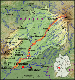
The Wetterau is a fertile undulating tract, watered by the Wetter, a tributary of the Nidda River, in the western German state of Hesse, between the hilly province Oberhessen and the north-western Taunus mountains.
Florstadt is a town in the Wetteraukreis, in Hesse, Germany. It is located approximately 26 kilometers northeast of Frankfurt am Main. It received town privileges in 2007.

The Wetter is a 69-kilometre-long (43 mi) river in the state of Hesse, Germany. It is a right tributary to the Nidda which itself is a right tributary of the Main.
The East Hesse Highlands describes a heavily wooded range of hills lying mainly in the German state of Hesse, but also extending a little way into Lower Saxony to the north, Thuringia to the east and Bavaria to the southeast. The region is sandwiched between the West Hesse Depression to the west, the Weser Uplands to the north, the Thuringian Basin to the northeast, the northwestern edge of the Thuringian Forest to the east, the Spessart to the south and the Wetterau to the southwest.

The Nidder is a 69 km-long (43 mi) river in Hesse, Germany, and part of the Main-Rhine system.

Rosbach is a river in Hesse, Germany, with a length of 9 kilometres (5.6 mi). The river is a right tributary of the Nidda which itself is a right tributary of the Main river in Hesse. The river Rosbach gives the town Rosbach vor der Höhe its name.

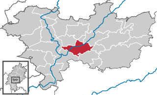
Bad Vilbel station is located at the 183.6 kilometre mark of the Main-Weser Railway in the town of Bad Vilbel in the German state of Hesse. The Nidder Valley Railway branches from Bad Vilbel via Nidderau to Glauburg-Stockheim. It is classified by Deutsche Bahn as a category 3 station.

The is a large volcanic mountain range in the German Central Uplands in the state of Hesse, separated from the Rhön Mountains by the Fulda river valley. Emerging approximately 19 million years ago, the Vogelsberg is Central Europe's largest basalt formation, consisting of a multitude of layers that descend from their peak in ring-shaped terraces to the base.
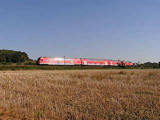
The Bad Vilbel–Glauburg-Stockheim railway is a non-electrified branch line in the Wetterau and the Main-Kinzig districts of the German state of Hesse. It connects the Main-Weser Railway in Bad Vilbel with the Gießen–Gelnhausen railway in Glauburg-Stockheim.
The town of Höchst am Main, now the Höchst district of Frankfurt, has a history stretching back over twelve hundred years. For a long time, Höchst was an independent town and an outpost of the Kurmainz region at the gates of Frankfurt. It was not incorporated into Frankfurt until 1928.