
Boston Spa is a village and civil parish in the City of Leeds in West Yorkshire, England. Situated 3 miles (5 km) south of Wetherby, Boston Spa is on the south bank of the River Wharfe across from Thorp Arch. According to the 2001 census, the parish had a population of 4,006 rising to 4,079 in the 2011 census.

Stanbury is a village and former civil parish, now in the parish of Haworth and Stanbury, in the metropolitan borough of the City of Bradford in West Yorkshire, England. In 1931 the parish had a population of 453. The name Stanbury translates as Stone Fort from Old English.

Linton is a village in the City of Leeds metropolitan borough, in West Yorkshire, England. It is 1.5 miles (2.4 km) south-west of Wetherby Wetherby on the north bank of the River Wharfe, Collingham is on the opposite bank.

Queensbury is a village in the metropolitan borough of Bradford, West Yorkshire, England. Perched on a high vantage point above Halifax, Clayton and Thornton and overlooking Bradford, Queensbury is one of the highest parishes in England, with views beyond the West Yorkshire conurbation to the hills of Brontë Country and the Yorkshire Dales to the north and north west. It's population of 8,718 in 2001 increased to 16,273 in the 2011 Census.

Rawcliffe is a village and civil parish in the East Riding of Yorkshire, England on the border with North Yorkshire. It is situated approximately 4 miles (6.4 km) west of Goole and 17 miles (27 km) south of York. It lies on the banks of the River Aire just north of the M62 and on the A614 road. Rawcliffe, along with nearby Airmyn, was the location of one of the first reliable reports of the practice of warping in agriculture in the 1730s.

Aysgarth is a village and civil parish in Wensleydale, in the Richmondshire district of North Yorkshire, England. The village is in the Yorkshire Dales National Park, about 16 miles (26 km) south-west of Richmond and 22.6 miles (36.4 km) west of the county town of Northallerton.

Buckden is a village and civil parish in the Craven district of North Yorkshire, England. Historically part of the West Riding of Yorkshire, Buckden is situated in the Yorkshire Dales National Park, and on the east bank of the River Wharfe in Wharfedale. The civil parish includes the hamlet of Cray and the whole of Langstrothdale. According to the 2011 Census the parish had a population of 187.

Overton is a small village and civil parish in the Hambleton district of North Yorkshire, England, about 4 miles (6.4 km) north-west of York. The population of civil parish taken at the 2011 Census was less than 100. Details are included in the civil parish of Shipton, North Yorkshire. The East Coast Main Line passes to the east, not far from the village.
Marske is a village and civil parish in the Richmondshire district of North Yorkshire, England, situated in lower Swaledale on the boundary of the Yorkshire Dales National Park, the village is approximately 5 miles (8 km) west of Richmond. According to the UK 2011 Census, the population of the parish of Marske, including New Forest was 127. The parish includes the hamlets of Applegarth, Clints, Feldom and Skelton.

West Scrafton is a village and civil parish in Coverdale in the Yorkshire Dales, England. It is located 4 miles (6.4 km) south west of Leyburn. It falls within the Richmondshire district of North Yorkshire. The population was estimated at 70 in 2013.

North Stainley is a village in the Harrogate district of North Yorkshire, England 4 miles (6.4 km) north of Ripon. Historically part of the West Riding of Yorkshire, it is the closest settlement to the theme park Lightwater Valley which is 0.62 miles (1 km) to the south.
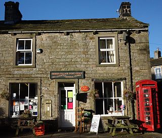
Hebden is a village and civil parish in the Craven District of North Yorkshire, England, and one of four villages in the ecclesiastical parish of Linton. It lies near Grimwith Reservoir and Grassington, in Wharfedale in the Yorkshire Dales National Park. In 2011 it had a population of 246.

Healey is a small village and civil parish in the Harrogate district of North Yorkshire, England. It is situated in the valley of the River Burn, to the immediate west of Fearby. It is about three miles west of Masham in the Nidderdale Area of Outstanding Natural Beauty. There are several holiday cottages and four Grade II Listed buildings, one of which is Healey Mill, a former corn mill.

Whitgift is a small linear village and former civil parish, now in the parish of Twin Rivers, in the East Riding of Yorkshire, England approximately 4 miles (6.4 km) east of Goole. It is located alongside the River Ouse and north of the A161 road between Goole and Scunthorpe. Ousefleet and Reedness are to the east and west respectively. Historically Whitgift was part of the West Riding of Yorkshire. In 1961 the parish had a population of 191.

Welton is a village and civil parish in the East Riding of Yorkshire, England. The parish extends to the bank of the Humber Estuary at its southern extreme, and into the Yorkshire Wolds in the northern part. The A63 road and Hull to Selby railway line both bisect the parish east–west, south of Melton and Welton.
Hunsingore is a village and civil parish in the Harrogate district of North Yorkshire, England. It is situated near the River Nidd and the A1(M) motorway, about 14 miles (23 km) west of York, and 4 miles (6.4 km) north east of Wetherby.

Roecliffe is a village and civil parish in the Harrogate district of North Yorkshire, England. It is situated near the A1 road motorway which connects London with Edinburgh and is 1 mile west of Boroughbridge. It is on the banks of the River Ure and the village centres on the village green which doubles up as the school playing field.

Summerbridge is a village in Nidderdale in Harrogate district, North Yorkshire, England. It is on the River Nidd, adjacent to Dacre Banks on the opposite bank of the river, and lies about 2.5 miles (4 km) south east of Pateley Bridge. The village is part of the historic West Riding of Yorkshire.

Grantley is a village and civil parish in North Yorkshire, England. It lies 5 miles (8 km) west of Ripon. The parish also includes the hamlet of Low Grantley. The population of the parish was estimated at 130 in 2013.

