
Ripon is a cathedral city and civil parish in North Yorkshire, England. The city is located at the confluence of two tributaries of the River Ure, the Laver and Skell. Within the boundaries of the historic West Riding of Yorkshire, the city is noted for its main feature, Ripon Cathedral, which is architecturally significant, as well as the Ripon Racecourse and other features such as its market.
Upper Poppleton is a village and civil parish in the unitary authority of the City of York in North Yorkshire, England. It is situated by the west bank of the River Ouse adjacent to Nether Poppleton, and west of York close to the A59 from York to Harrogate. The village is served by Poppleton railway station on the Harrogate Line. According to the 2001 census, the parish had a population of 1,961, increasing to 1,997 at the 2011 Census. Before 1996, it was part of the Borough of Harrogate.

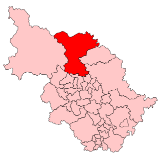
The Borough of Harrogate was a local government district with borough status in North Yorkshire, England, from 1974 to 2023. Its council was based in the town of Harrogate, but it also included surrounding settlements, including the cathedral city of Ripon, and almost all of the Nidderdale Area of Outstanding Natural Beauty. At the 2011 Census, the borough had a population of 157,869.

Skipton and Ripon is a constituency in North Yorkshire represented in the House of Commons of the UK Parliament since 2010 by Julian Smith, a Conservative.

Pateley Bridge is a market town in the civil parish of High and Low Bishopside, in Nidderdale, in the county and district of North Yorkshire, England. Historically part of the West Riding of Yorkshire, it lies on the River Nidd. It is in the Yorkshire Dales and just outside the Yorkshire Dales National Park.
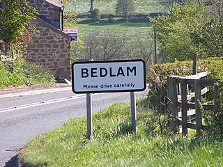
Bedlam is a small village in the Harrogate district of North Yorkshire, England situated north of Harrogate.

Nidderdale, historically also known as Netherdale, is one of the Yorkshire Dales in North Yorkshire, England. It is the upper valley of the River Nidd, which flows east from its source, then south underground for 2 miles (3 km) and then south-east along the dale, forming several reservoirs including the Gouthwaite Reservoir, before turning east and eventually joining the River Ouse.

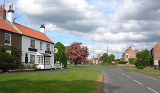
Burton Leonard is a village and civil parish in the former Harrogate district of North Yorkshire, England, and approximately 7 miles (11 km) south from Ripon. In the 2001 Census, the population of the village was 654, which had risen to 690 by the time of the 2011 Census. In 2015, North Yorkshire County Council estimated the population had dropped to 670.

Killinghall is a village and civil parish in the Harrogate district of North Yorkshire, England. The civil parish population taken at the 2011 census was 4,132.
Ripon was a constituency sending members to the House of Commons of England, Great Britain and the House of Commons of the Parliament of the United Kingdom until 1983, centred on the city of Ripon in North Yorkshire.

Glasshouses is a small village in Nidderdale, North Yorkshire, England. It lies 1 mile (1.6 km) south-east of Pateley Bridge on the east side of Nidderdale and has a recently rebuilt river bridge across the River Nidd. In 2019 it had an estimated population of 536.

Healey is a small village and civil parish in the Harrogate district of North Yorkshire, England. It is situated in the valley of the River Burn, to the immediate west of Fearby. It is about three miles west of Masham in the Nidderdale Area of Outstanding Natural Beauty. There are several holiday cottages and four Grade II Listed buildings, one of which is Healey Mill, a former corn mill.

Risplith is a village in the civil parish of Sawley, in the Harrogate district of North Yorkshire, England. It is about 4 miles (6.4 km) west of Ripon on the B6265 road to Pateley Bridge. The name is believed to derive from Old Norse of slope overgrown with brushwood.

Summerbridge is a village in Nidderdale in North Yorkshire, England. It is on the River Nidd, adjacent to Dacre Banks on the opposite bank of the river, and lies about 2.5 miles (4 km) south east of Pateley Bridge. The village is part of the historic West Riding of Yorkshire.

Clint is a village in Nidderdale in North Yorkshire, England. It lies on the north bank of the River Nidd, 4 miles north-west of Harrogate. Clint is the largest village in the civil parish of Clint cum Hamlets, which also includes the settlements of Burnt Yates and Bedlam.

The Nidderdale Way is a 55-mile (89 km) circular long distance footpath in Nidderdale in North Yorkshire, England.
High and Low Bishopside is a civil parish in Nidderdale in the Harrogate district, in the county of North Yorkshire, England. It includes the town of Pateley Bridge and the villages of Glasshouses and Wilsill, the southern part of Wath and the hamlets of Blazefield, and Fellbeck. The parish touches Bewerley, Dacre, Eavestone, Fountains Earth, Hartwith cum Winsley, Laverton, Sawley, Stonebeck Down and Warsill. In 2011 the parish had a population of 2,210. There are 39 listed buildings in High and Low Bishopside. The parish's council is called "Pateley Bridge Town Council".
Clint cum Hamlets is a civil parish in the former Harrogate district of North Yorkshire, England. It contains ten listed buildings that are recorded in the National Heritage List for England. All the listed buildings are designated at Grade II, the lowest of the three grades, which is applied to "buildings of national importance and special interest". The parish contains the settlements of Bedlam, Burnt Yates and Clint, and the surrounding countryside. The listed buildings consist of houses, farmhouses and farm buildings, a cross base and stocks, a school and a sundial in its grounds, and a bridge.
Burnt Yates School was a primary school in the village of Burnt Yates, in North Yorkshire, in England.

