Nidderdale

Last updated

Upper Nidderdale Upper Nidderdale.JPG
Upper Nidderdale
Winter in Nidderdale Winter in Nidderdale.jpg
Winter in Nidderdale

Nidderdale, historically also known as Netherdale, [1] is one of the Yorkshire Dales (although outside the Yorkshire Dales National Park) [2] in North Yorkshire, England. It is the upper valley of the River Nidd, which flows south underground and then along the dale, forming several reservoirs including the Gouthwaite Reservoir, before turning east and eventually joining the River Ouse.

Contents

The only town in the dale is Pateley Bridge. Other settlements include Wath, Ramsgill, Lofthouse, and Middlesmoor above Pateley Bridge, and Bewerley, Glasshouses, Summerbridge, Dacre, Darley, Birstwith, Hampsthwaite and Kettlesing below Pateley.

Area of Outstanding Natural Beauty

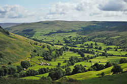
Nidderdale was designated an Area of Outstanding Natural Beauty in 1994. [3] The AONB covers a much wider area than Nidderdale. In addition to Nidderdale itself (above Hampsthwaite), the AONB includes part of lower Wharfedale, the Washburn valley and part of lower Wensleydale, including Jervaulx Abbey and the side valleys west of the River Ure. The highest point in the Nidderdale AONB is Great Whernside, 704 metres above sea level, on the border with the Yorkshire Dales National Park.

The AONB Web site provides directions for popular walks and offers information on canoeing and kayaking, caving, climbing, cycling, fishing and horse riding. [4]

Local government

Nidderdale was historically in the West Riding of Yorkshire, and in the Lower Division of Claro Wapentake. In the 19th century local government reforms most of the dale fell within the Pateley Bridge Poor Law Union, [5] later the Pateley Bridge Rural Sanitary District [6] and from 1894 Pateley Bridge Rural District. [7] In 1937 the rural district was merged to become part of Ripon and Pateley Bridge Rural District. [8] Hampsthwaite and Felliscliffe in the lower dale fell within Knaresborough Poor Law Union, later Knaresborough Rural Sanitary District and from 1894 Knaresborough Rural District, which merged in 1938 to become part of Nidderdale Rural District. [9]

Since 1974 the whole dale has fallen within the Borough of Harrogate in North Yorkshire.

Transport

A Nidderdale Omnibus started operating on 1 August 1849 and ran between Pateley Bridge and Ripley Station. In 1862 the North Eastern Railway opened the Nidd Valley Railway from Nidd Valley Junction near Harrogate to Pateley Bridge. Between 1907 and 1937 the Nidd Valley Light Railway served the dale above Pateley Bridge. The Pateley Bridge branch closed in 1964.

Nidderdale is now served by the buses of Harrogate Bus Company.

In 2020, the AONB Web site provided these specifics. The area can be reached by bus "from Harrogate to Pateley Bridge; The Transdev Harrogate & District number 24 service runs regularly from Harrogate to Pateley Bridge. Nidderdale is also well served by DalesBus services". The nearest train station is at Harrogate. Highway access is via "A1(M) and the A61 to the east, and the A65, A59, M65 and M62 to the south". [10]

Filming location

All Creatures Great and Small (2020 TV series) was filmed mostly in the Yorkshire Dales with many of the Dales scenes filmed in Wharfedale and Nidderdale. [11] For example, the crossroads that are so important in the Christmas episode are "on the roads above Pateley Bridge" in Nidderdale. [12]

Related Research Articles

<span class="mw-page-title-main">Yorkshire Dales</span> Upland area of the Pennines in Northern England

The Yorkshire Dales are an upland area of the Pennines in England. Most of the area is in the county of North Yorkshire, but it extends into Cumbria and a small part of Lancashire. It was historically entirely within Yorkshire. The majority of the Dales are part of the Yorkshire Dales National Park, created in 1954. The exception is the area around Nidderdale, which forms the separate Nidderdale Area of Outstanding Natural Beauty.

<span class="mw-page-title-main">Borough of Harrogate</span> Former local government district in England

The Borough of Harrogate was a local government district with borough status in North Yorkshire, England, from 1974 to 2023. Its council was based in the town of Harrogate, but it also included surrounding settlements, including the cathedral city of Ripon, and almost all of the Nidderdale Area of Outstanding Natural Beauty. At the 2011 Census, the borough had a population of 157,869.

<span class="mw-page-title-main">Darley, North Yorkshire</span> Village in North Yorkshire, England

Darley is a linear village in Nidderdale in the Harrogate district of North Yorkshire, England. The population as at the 2011 Census is 1,332 and is included in the civil parish of Darley and Menwith. The village extends for 1 mile east from a junction with the B6451 road. The western end of the village is known as Darley Head and the eastern end as The Holme. Darley has won many local and national 'Britain in Bloom' awards.

<span class="mw-page-title-main">Skipton and Ripon (UK Parliament constituency)</span> Parliamentary constituency in the United Kingdom, 1983 onwards

Skipton and Ripon is a constituency in North Yorkshire represented in the House of Commons of the UK Parliament since 2010 by Julian Smith, a Conservative.

<span class="mw-page-title-main">Pateley Bridge</span> Market town in North Yorkshire, England

Pateley Bridge is a market town in Nidderdale in the county and district of North Yorkshire, England. Historically part of the West Riding of Yorkshire, it lies on the River Nidd. It is in the Yorkshire Dales and just outside the Yorkshire Dales National Park.

<span class="mw-page-title-main">Nidderdale AONB</span> Area of Outstanding Natural Beauty in England

The Nidderdale AONB is an Area of Outstanding Natural Beauty in North Yorkshire, England, bordering the Yorkshire Dales National Park to the east and south. It comprises most of Nidderdale itself, part of lower Wharfedale, the Washburn valley and part of lower Wensleydale, including Jervaulx Abbey and the side valleys west of the River Ure. It covers a total area of 233 square miles (600 km2). The highest point in the Nidderdale AONB is Great Whernside, 704 metres (2,310 ft) above sea level, on the border with the Yorkshire Dales National Park.

Nidderdale was a rural district in the West Riding of Yorkshire from 1938 to 1974. It was created from the combination of most of the disbanded rural districts of Great Ouseburn and Knaresborough.

Ripon and Pateley Bridge was a rural district in the West Riding of Yorkshire, England from 1937 to 1974.

<span class="mw-page-title-main">Hampsthwaite</span> Village and civil parish in North Yorkshire, England

Hampsthwaite is a large village and civil parish in Nidderdale in the Harrogate district of North Yorkshire, England. It lies on the south bank of the River Nidd 5 miles (8 km) north west of Harrogate. In the 2011 census the parish had a population of 1,083.

<span class="mw-page-title-main">River Nidd</span> River in North Yorkshire, England

The River Nidd is a tributary of the River Ouse in the English county of North Yorkshire. In its first few miles it is dammed three times to create Angram Reservoir, Scar House Reservoir and Gouthwaite Reservoir, which attract a total of around 150,000 visitors a year. The Nidd can overflow the reservoirs, flooding the caves in the valley. In such cases the river overflows into the normally dry river bed past Lofthouse through to Gouthwaite Reservoir. The Yorkshire Dales Rivers Trust YDRT has a remit to conserve the ecological condition of the River Nidd from its headwaters to the Humber estuary.

<span class="mw-page-title-main">Glasshouses, North Yorkshire</span> Village in North Yorkshire, England

Glasshouses is a small village in Nidderdale, North Yorkshire, England. It lies 1 mile (1.6 km) south-east of Pateley Bridge on the east side of Nidderdale and has a recently rebuilt river bridge across the River Nidd. In 2019 it had an estimated population of 536.

<span class="mw-page-title-main">William Grainge</span> 19th-century English historian

William Grainge was an English antiquarian and poet, and a historian of Yorkshire. He was born into a farming family in Dishforth and grew up on Castiles Farm near Kirkby Malzeard in the North Riding of Yorkshire, where he studied the archaeological site beneath the farm buildings, now known as Cast Hills settlement. Although he left school at age 12, he educated himself well enough to become a clerk to a solicitors' firm in Boroughbridge. He later established a bookshop in Harrogate and published numerous books on local history and topography, besides publishing a number of anonymous poems and discourses about local natural history.

The Six Dales Trail is a long distance footpath in North Yorkshire, England, with a short section in West Yorkshire. It is 38 miles (61 km) long and connects Otley and Middleham.

<span class="mw-page-title-main">Nidd Valley Railway</span> Disused railway line in Yorkshire, England

The Nidd Valley Railway was a 11.5-mile (18.5 km) long single-track branch railway line that ran along the valley of the River Nidd in North Yorkshire, England. Built by the North Eastern Railway, it ran from Ripley Junction, on the Harrogate to Ripon Line, to Pateley Bridge via five intermediate stations, Ripley Valley, Hampsthwaite, Birstwith, Darley, and Dacre.

<span class="mw-page-title-main">Nidderdale Way</span> Long-distance footpath in North Yorkshire, England

The Nidderdale Way is a 54-mile (87 km) circular long distance footpath in Nidderdale in North Yorkshire, England.

<span class="mw-page-title-main">Nidderdale Greenway</span>

The Nidderdale Greenway is a 4-mile (6.4 km) path that runs between Harrogate and Ripley in North Yorkshire, England. It uses a former railway line that ran between Harrogate and Pateley Bridge as its course. The route connects to other cycle paths including the Way of the Roses.

<span class="mw-page-title-main">Scotgate Ash Quarry</span> Disused quarry in North Yorkshire, England

Scotgate Ash Quarry or Scot Gate Ash Quarry, was the collective name for extensive quarry workings that were on the northern edge of Pateley Bridge, North Yorkshire, England. When the quarry was last in use, the area was in the West Riding of Yorkshire, and was described as being the largest quarry in West Yorkshire.

Lofthouse-in-Nidderdale railway station was the northernmost regular passenger terminus on the Nidd Valley Light Railway (NVLR), in Lofthouse, then in the West Riding of Yorkshire and now in North Yorkshire, England. The station was built as part of Bradford Corporation's programme of reservoir building in the Upper Nidd Valley. The station opened in 1904 and was closed to passengers in 1930. The station was renamed Lofthouse-in-Nidderdale railway station in 1907 to avoid confusion with Lofthouse and Outwood railway station, also in the West Riding of Yorkshire.

<span class="mw-page-title-main">High and Low Bishopside</span> Civil parish in North Yorkshire, England

High and Low Bishopside is a civil parish in Nidderdale in the Harrogate district, in the county of North Yorkshire, England. It includes the town of Pateley Bridge and the villages of Glasshouses and Wilsill, the southern part of Wath and the hamlets of Blazefield, and Fellbeck. The parish touches Bewerley, Dacre, Eavestone, Fountains Earth, Hartwith cum Winsley, Laverton, Sawley, Stonebeck Down and Warsill. In 2011 the parish had a population of 2,210. There are 39 listed buildings in High and Low Bishopside. The parish's council is called "Pateley Bridge Town Council".

References

  1. Smith, A. H. (1961). The Place-names of the West Riding of Yorkshire. Vol. 5. Cambridge University Press. p. 76.
  2. "Nidderdale". www.yorkshire-dales.com. Retrieved 27 February 2021.
  3. "Nidderdale Area of Outstanding Natural Beauty". Visit Harrogate. Retrieved 15 May 2015.
  4. Planning Your Trip
  5. Vision of Britain: Pateley Bridge RegD/PLU
  6. Vision of Britain: Pateley Bridge RSD
  7. Vision of Britain: Pately Bridge RD
  8. Vision of Britain: Ripon and Pateley Bridge RD
  9. Vision of Britain: Knaresborough RD
  10. Planning your visit
  11. "WHERE WAS ALL CREATURES GREAT AND SMALL FILMED?". HITC. 20 December 2020. Retrieved 27 February 2021.
  12. "Where are the recent All Creatures Great and Small Yorkshire locations filmed?". Yorkshire Post. 21 February 2021. Retrieved 25 February 2021.

Commons-logo.svg Media related to Nidderdale at Wikimedia Commons

54°05′12″N1°45′28″W / 54.086688°N 1.757728°W / 54.086688; -1.757728