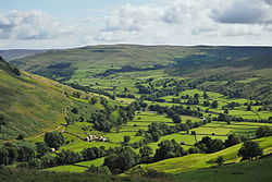
Garsdale

Last updated

Garsdale
Garsdale in 2007.jpg
Garsdale
Location map United Kingdom South Lakeland.svg
Red pog.svg
Garsdale
Location in South Lakeland
Cumbria UK location map.svg
Red pog.svg
Garsdale
Location within Cumbria
Population191 (2011) [1]
OS grid reference SD7489
Civil parish
  • Garsdale
District
Shire county
Region
Country England
Sovereign state United Kingdom
Post town SEDBERGH
Postcode district LA10
Dialling code 015396
Police Cumbria
Fire Cumbria
Ambulance North West
UK Parliament
List of places
UK
England
Cumbria
54°18′04″N2°23′28″W / 54.301°N 2.391°W / 54.301; -2.391

Garsdale is a dale or valley in the south east of Cumbria, England, historically a part of the West Riding of Yorkshire. It is now within the Westmorland and Furness local government district, and in the Yorkshire Dales National Park for planning purposes. In the 2001 census the parish had a population of 202, [2] decreasing at the 2011 census to 191. [1]

Contents

Garsdale is on the western slopes of the Pennines, between Baugh Fell to the north, and Rise Hill to the south. It is within the Yorkshire Dales National Park. The dale is the valley of the Clough River, which rises on the north eastern slopes of Baugh Fell and flows through Grisedale, the Dale that Died, as Grisedale Beck until it becomes the Clough River at Garsdale Head.

The dale forms the civil parish of Garsdale (though the last mile and a half of the course of the Clough river, before its confluence with the Rawthey, is part of the parish of Sedbergh). Small settlements lie along the main Northallerton to Kendal road (the A684) which runs through the dale for 7 miles (11 km), with frequent bridges in the upper part of the dale. The largest settlement, known as "The Street", lies 6 miles (9.7 km) east of Sedbergh, and 10 miles (16 km) west of Hawes. The other hamlet in Garsdale is Garsdale Head, also called Hawes Junction, the old name for Garsdale railway station, after the former Wensleydale branch on the Settle to Carlisle railway.

At Longstone Fell, locally known, and spoken as Langst'n Fell, the A684 road rises to a well-known view-point looking over the Howgill Fells, and the river descends to Danny Bridge, the site of a 17th-century mill on the "old road", before joining the River Rawthey near Sedbergh. The Sedgwick Trail, named after the well-known geologist Adam Sedgwick runs along the Clough from Danny Bridge and highlights rock features along the Dent Fault.

History

Historically, Garsdale was a chapelry in the ancient parish of Sedbergh in the Ewecross wapentake in the West Riding of Yorkshire. In 1866 it became a separate civil parish. [3] From 1894 to 1974 it was part of Sedbergh Rural District. In 1974 it became part of the new county of Cumbria. [4]

Churches

The Anglican Church of St John the Baptist, built in 1861 next to the original medieval church, lies 6 miles (9.7 km) from Sedbergh, between The Street and Garsdale Hall, which was once an inn but is now used as a farm store. There are also three Methodist chapels: Low Smithy and Garsdale Street, both in regular use, and Hawes Junction which has occasional special events.

Farming

Garsdale has numerous working farms, most of them amalgamating several of the original smallholdings. Because of the high annual rainfall of up to 100 inches (2,500 mm), crops other than hay and silage are almost impossible, so all farms are stock rearing. Pedigree Swaledale rams occasionally make high prices at Hawes Auction mart.

Ruswarp

Statue of Ruswarp at Garsdale Railway Station Ruswarp - geograph.org.uk - 1259798.jpg
Statue of Ruswarp at Garsdale Railway Station

At Garsdale railway station stands a statue of Ruswarp, a collie. Ruswarp belonged to Graham Nuttall, the first Secretary of the Friends of the Settle–Carlisle Line, which was formed to campaign against the proposed closure of the line. Ruswarp's paw print was put on his own objection as a fare-paying passenger. The line was finally saved in 1989. In January 1990 Nuttall and Ruswarp went missing in the Welsh mountains. On 7 April 1990 a lone walker found Nuttall's body, by a mountain stream. Nearby was Ruswarp, so weak that the 14-year-old dog had to be carried off the mountain. He had stayed with his master's body for 11 winter weeks. The Royal Society for the Prevention of Cruelty to Animals awarded Ruswarp their Animal Medallion and collar for 'vigilance' and their Animal Plaque for 'intelligence and courage'. He survived long enough to attend Nuttall's funeral. [5] The statue by Joel Walker was unveiled in 2009. [6]

Governance

Garsdale is part of the Westmorland and Lonsdale parliamentary constituency, of which Tim Farron is the current MP representing the Liberal Democrats. [7]

For the European Parliament residents in Garsdale voted to elect MEP's for the North West England constituency.

For local government purposes it is in the Kirkby Lonsdale Ward of South Lakeland District Council and the Sedbergh + Kirkby Lonsdale Division of Cumbria County Council.

Garsdale has its own Parish Council; Garsdale Parish Council. [8]

Notable people

Famous people born in Garsdale include:

See also

Bibliography

Related Research Articles

<span class="mw-page-title-main">Kirkby Lonsdale</span> Town and civil parish in Cumbria, England

Kirkby Lonsdale is a town and civil parish in the Westmorland and Furness district of Cumbria, England, on the River Lune. Historically in Westmorland, it lies 13 miles (21 km) south-east of Kendal on the A65. The parish recorded a population of 1,771 in the 2001 census, increasing to 1,843 at the 2011 Census.

<span class="mw-page-title-main">Yorkshire Dales National Park</span> National park in England

The Yorkshire Dales National Park is a 2,178 km2 (841 sq mi) national park in England covering most of the Yorkshire Dales, with the notable exception of Nidderdale. Most of the park is in North Yorkshire, with a sizeable area in Cumbria and a small part in Lancashire. The park was designated in 1954, and extended in 2016. Over 95% of the land in the Park is under private ownership; there are over 1,000 farms in this area.

<span class="mw-page-title-main">South Lakeland</span> Former local government district in England

South Lakeland was a local government district in Cumbria, England, from 1974 to 2023. Its council was based in Kendal. The district covered the southern part of the Lake District region, as well as northwestern parts of the Yorkshire Dales. At the 2011 Census, the population of the district was 103,658, an increase from 102,301 at the 2001 Census.

<span class="mw-page-title-main">Sedbergh</span> Town in Cumbria, England

Sedbergh is a town and civil parish in the ceremonial county of Cumbria. It falls within the historic boundaries of the West Riding of Yorkshire. Since April 2023, it has been administered by Westmorland and Furness local authority. The 2001 census gave the parish a population of 2,705, increasing at the 2011 census to 2,765. It lies about 10 miles (16 km) east of Kendal, 28 miles (45 km) north of Lancaster and about 10 miles (16 km) north of Kirkby Lonsdale, within the Yorkshire Dales National Park. It stands at the foot of Howgill Fells, on the north bank of the River Rawthey, which joins the River Lune 2 miles (3 km) below the town.

<span class="mw-page-title-main">Dent, Cumbria</span> Village and civil parish in Cumbria, England

Dent is a village and civil parish in Cumbria, England, within the historic boundaries of the West Riding of Yorkshire. It lies in Dentdale, a narrow valley on the western slopes of the Pennines within the Yorkshire Dales National Park, 4 miles (6 km) south east of Sedbergh and 8 miles (13 km) north east of Kirkby Lonsdale. At the 2011 census, Dent and Middleton had a total population of 785.

<span class="mw-page-title-main">Barony of Kendal</span> Subdivision of the English historic county of Westmorland

The Barony of Kendal is a subdivision of the English historic county of Westmorland. It is one of two ancient baronies that make up the county, the other being the Barony of Westmorland. In 1974, the entire county became part of the modern county of Cumbria and ceased to have an administrative function. At the same time, Kendal borough along with some other rural and urban districts in Westmorland was merged with the neighbouring parts of Lancashire, Furness and Cartmel, and also the Sedbergh Rural District of the West Riding of Yorkshire into the new South Lakeland district of the new county.

<span class="mw-page-title-main">Garsdale railway station</span> Railway station in Cumbria, England

Garsdale is a railway station in Cumbria, England, on the Settle and Carlisle Line, which runs between Carlisle and Leeds via Settle. The station, situated 51 miles 29 chains (82.7 km) south-east of Carlisle, serves the village of Garsdale and town of Sedbergh, South Lakeland in Cumbria, and the market town of Hawes, Richmondshire in North Yorkshire. It is owned by Network Rail and managed by Northern Trains.

<span class="mw-page-title-main">Garsdale Head</span> Landform watershed in Northern England

Garsdale Head is a hamlet mainly within the South Lakeland district of Cumbria, England. Historically part of the West Riding of Yorkshire, the hamlet is now on the border with Richmondshire, North Yorkshire. It lies within the boundaries of the Yorkshire Dales National Park.

<span class="mw-page-title-main">River Rawthey</span> River in Cumbria, England

The River Rawthey is a river in Cumbria in northwest England.

<span class="mw-page-title-main">Clough River</span> River in Cumbria, England

The Clough River is a river in Cumbria, England. A tributary of the River Rawthey, it flows for 21.8 kilometres (13.5 mi) primarily through the Garsdale valley.

<span class="mw-page-title-main">A684 road</span> A road in Northern England

The A684 is an A road that runs through Cumbria and North Yorkshire, starting at Kendal, Cumbria and ending at Ellerbeck and the A19 road in North Yorkshire. It crosses the full width of the Yorkshire Dales, passing through Garsdale and the full length of Wensleydale.

<span class="mw-page-title-main">Baugh Fell</span> Large, flat-topped hill in the northern Pennines of England

Baugh Fell is a large, flat-topped hill in the northern Pennines of England. It lies in the north-western corner of the Yorkshire Dales National Park, immediately to the east of the Howgill Fells and to the north of Whernside, the highest of the Yorkshire Three Peaks. Formerly in the West Riding of Yorkshire, since 1974 it has been part of the county of Cumbria.

<span class="mw-page-title-main">Dentdale</span> Valley in Cumbria, England

Dentdale is a dale or valley in the north-west of the Yorkshire Dales National Park in Cumbria, England. It is the valley of the River Dee, but takes its name from the village of Dent. The dale runs east to west, starting at Dent Head, which is the location of a railway viaduct on the Settle-Carlisle Line.

<span class="mw-page-title-main">Cowgill, Cumbria</span> Village in England

Cowgill is a village in Westmorland and Furness, Cumbria, England. It is within the historic boundaries of the West Riding of Yorkshire, and is located 9 miles (14 km) south east of Sedbergh. The village is served by Dent railway station on the Settle-Carlisle Line with services north towards Appleby-in-Westmorland and Carlisle and south towards Skipton and Leeds.

<span class="mw-page-title-main">Dales High Way</span>

A Dales High Way is a long-distance footpath in northern England. It is 90 miles (140 km) long and runs from Saltaire in West Yorkshire to Appleby-in-Westmorland, Cumbria, roughly parallel to the line of the Settle and Carlisle Railway.

The geology of the Yorkshire Dales National Park in northern England largely consists of a sequence of sedimentary rocks of Ordovician to Permian age. The core area of the Yorkshire Dales is formed from a layer-cake of limestones, sandstones and mudstones laid down during the Carboniferous period. It is noted for its karst landscape which includes extensive areas of limestone pavement and large numbers of caves including Britain's longest cave network.

<span class="mw-page-title-main">Coal Road</span> Ancient road in Cumbria, England

The Coal Road is an unclassified highway which connects the railway stations at Garsdale and Dent in Cumbria, England. The road is within the Yorkshire Dales National Park, and was historically part of the West Riding of Yorkshire. The name derives from its use transporting locally mined coal, although before that it was used as a droving route between England and Scotland through Mallerstang.

<span class="mw-page-title-main">Moorcock Inn</span> Pub in the Yorkshire Dales, England

The Moorcock Inn is a public house at the watershed of the Eden, Clough and Ure rivers, in Upper Wensleydale, North Yorkshire, England. It is adjacent to the A684 road where it has a junction with the B6259 road, and near to Garsdale railway station on the Settle–Carlisle line. The history of the inn can be traced back to the 1740s, but it has only been named The Moorcock since 1840. The pub is near to some long-distance paths, and is popular with walkers.

<span class="mw-page-title-main">Grisedale</span> Dale in Cumbria, England

Grisedale is a south east facing Dale in Cumbria, England, 8 miles (13 km) east of Sedbergh, and 7 miles (11 km) west of Hawes. Grisedale Beck, which drains Baugh Fell, flows down the dale eastwards, and on reaching the valley floor at Garsdale, forms the River Clough before turning westwards towards the Irish Sea. A small part of the north-eastern side of the dale is in North Yorkshire, however, until 1974, all of the area around, and including Grisedale, was part of the West Riding of Yorkshire. The dale was largely depopulated of its working farmers during the 20th century, however, some of the houses have been re-occupied by non-agricultural inhabitants.

References

  1. 1 2 UK Census (2011). "Local Area Report – Garsdale Parish (E04002606)". Nomis. Office for National Statistics . Retrieved 1 May 2021.
  2. UK Census (2001). "Local Area Report – Garsdale Parish (16UG023)". Nomis. Office for National Statistics . Retrieved 1 May 2021.
  3. Great Britain Historical GIS / University of Portsmouth, Garsdale CP/Ch . Retrieved 6 October 2022.
  4. "History of Garsdale, in South Lakeland and West Riding | Map and description". www.visionofbritain.org.uk. Retrieved 25 November 2020.
  5. Illingworth, John. "Ruswarp". Geograph Project. Retrieved 30 March 2011.
  6. "Dog who stayed by dead master's side for 11 weeks honoured with statue". 29 August 2008. Retrieved 7 April 2020.
  7. "Tim Farron". theyworkforyou.com. Archived from the original on 1 June 2013.
  8. "Garsdale Parish Council".
  9. Speight, Harry (1892). The Craven and North-West Yorkshire Highlands. London: Elliot Stock. p. 418. OCLC   1157926819.