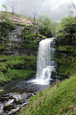
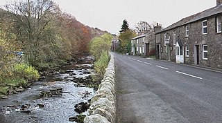
The headwaters of the Rawthey are at Rawthey Gill Foot, where Rawthey Gill meets Haskhaw Gill. The source of Rawthey Gill is unclear, but is either on Knoutberry Haw or near to the East Tarns of Baugh Fell. Moving initially northwards, the Rawthey picks up Whin Stone Gill in Uldale before skirting round Bluecaster, after which the river runs south-southwest through Cautley. The Rawthey is joined by the Clough River, coming from Garsdale, near Dowbiggin, and, having run past Castleshaw Tower, the River Dee close to Sedbergh. The Rawthey joins the Lune at Stangerthwaite soon afterwards.
Most of the country through which the Rawthey runs is part of the historic West Riding of Yorkshire.
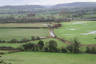
The River Ouse is a river in North Yorkshire, England. Hydrologically, the river is a continuation of the River Ure, and the combined length of the River Ure and River Ouse makes it, at 129 miles (208 km), the sixth longest river of the United Kingdom and the longest to flow entirely in one county. The length of the Ouse alone is about 52 miles (84 km) but the total length of the river is disputed.
The River Derwent is a river which flows between the historic county boundaries of Durham and Northumberland in the north east of England. It broadens into the Derwent Reservoir, west of Consett. The Derwent is a tributary of the River Tyne, which it joins near the MetroCentre near Gateshead. The river flows for 35 miles from its origin, where two streams, Beldon Burn and Nookton Burn meet approximately a mile west of Blanchland, to Derwenthaugh where it flows into the River Tyne. On its journey, the river flows through places such as Allensford, Shotley Bridge, Blackhall Mill and Rowlands Gill. The Derwent Walk Country Park at Rowlands Gill is named after the river.
The Dales Way is an 78.5-mile (126.3 km) long-distance footpath in Northern England, from Ilkley, West Yorkshire, to Bowness-on-Windermere, Cumbria. This walk was initially devised by the West Riding Ramblers' Association with the 'leading lights' being Colin Speakman and Tom Wilcock. The route was announced to the public in 1968 and the first recorded crossing was by a group of Bradford Grammar School Venture Scouts in 1969.
The Howgill Fells are hills in Northern England between the Lake District and the Yorkshire Dales, lying roughly in between the vertices of a triangle made by the towns of Sedbergh, Kirkby Stephen and Tebay. The name Howgill derives from the Old Norse word haugr meaning a hill or barrow, plus gil meaning a narrow valley.
The River Mite is a river in the county of Cumbria in northern England.
The River Sherbourne is a river that flows under the centre of the city of Coventry, in the West Midlands, in England.
Glenderaterra Beck is a watercourse in the county of Cumbria, England. The length of the Glenderaterra, and its major tributary Whit Beck is 4.8 miles (7.8 km), which have a total catchment area of 11.8 square kilometres (4.6 sq mi).
The River Wampool is a river flowing through north western Cumbria in England. It is in the Waver and Wampool catchment which includes the towns of Silloth and Wigton.
The River Twiss is a river in the county of Yorkshire, England. The source of the river is Kingsdale Beck which rises at Kingsdale Head at the confluence of Back Gill and Long Gill in the Yorkshire Dales. Beneath Keld Head, it changes its name to the River Twiss. It has two notable waterfalls, Thornton Force and Pecca Falls, and its course follows part of the Ingleton Waterfalls Walk, then through Swilla Glen to Thornton in Lonsdale and down to Ingleton, where it meets the River Doe to form the River Greta.
The River Dee is a river running through the extreme south east of Cumbria, a part of the Craven region traditionally part of the West Riding of Yorkshire. Its name possibly derives from Brythonic deva meaning goddess, or from Dent or Dentdale, through which the river flows.
The Clough River is a river in Cumbria, England. A tributary of the River Rawthey, it flows for 21.8 kilometres (13.5 mi) primarily through the Garsdale valley.
The River Loud is a river of Lancashire, England.
Garsdale is a dale or valley in the south east of Cumbria, England, historically a part of the West Riding of Yorkshire. It is now within the South Lakeland local government district, but is still a "Yorkshire Dale" for planning purposes. In the 2001 census the parish had a population of 202, decreasing at the 2011 census to 191.
Skirden Beck is a minor river in Lancashire, England. It is approximately 4.3 miles (6.85 km) long and has a catchment area of 18.87 square miles (48.882 km2).
The River Irvine is a river that flows through southwest Scotland. Its watershed is on the Lanarkshire border of Ayrshire at an altitude of 810 feet (250 m) above sea-level, near Loudoun Hill, Drumclog, and 7 miles SW by W of Strathaven. It flows 29+1⁄2 mi (47.5 km) westward, dividing the old district of Cunninghame from that of Kyle, until it reaches the sea via Irvine Harbour in the form of the Firth of Clyde, and flows into Irvine Bay by the town of Irvine. It has many tributaries, some of which form parish, district and other boundaries.
The River Greta is a river in County Durham, England. It is a tributary of the River Tees and flows through the northern part of the old North Riding of Yorkshire. The name "Greta" derives from the Old Norse "Griótá", meaning "stony stream".
The Lox Yeo is a short river in North Somerset, England. It rises at Winscombe and flows south west for about 6 kilometres (4 mi) to join the River Axe near Loxton.
The River Allen in north Cornwall is one of two rivers in Cornwall which share this name. In this case the name is the result of a mistake made in 1888 by Ordnance Survey, replacing the name Layne with Allen which is the old name for the lower reaches of the Camel. The other River Allen runs through Truro.
Nadari river is a river that runs through the Indian states of Andhra Pradesh and Tamil Nadu. The Nadari river originates in the Velikonda mountains near Puttur and runs for about 100 kilometres (62 mi) through Nellore and Thiruvallur districts before joining the Buckingham Canal and joining the Bay of Bengal near Ennore.
The R265 is a Regional road wholly within County Donegal in Ireland, it runs north to south from near Newtown Cunningham to Rossgier near Lifford the County Town. The road runs from near Lough Swilly and generally along the west bank of the River Foyle. The road runs through mostly arable farmland in the East Donegal area.
This page is based on this Wikipedia article Text is available under the CC BY-SA 4.0 license; additional terms may apply. Images, videos and audio are available under their respective licenses.