A684 road

Last updated

UK road A684.svg
A684
Moorcock Inn, Garsdale Head, Yorkshire, England - 1900-05.jpg
A view looking east from Dandry Mire Viaduct at Garsdale Head c.1900. Moorcock Inn is still trading as a pub and the view remains largely unchanged in this rural upland scene.
Route information
Length70 mi (110 km)
Major junctions
West end Kendal
54°19′49″N2°44′29″W / 54.3303°N 2.7413°W / 54.3303; -2.7413 (A684 road (western end))
Major intersectionsA6
UK-Motorway-M6.svg M6
UK road A683.svg A683
UK road A6108.svg A6108
UK road A6055.svg A6055
A1(M)
UK road A167.svg A167
A19
East end Ellerbeck (A19 road)
54°22′07″N1°19′15″W / 54.3685°N 1.3209°W / 54.3685; -1.3209 (A684 road (eastern end))
Location
Country United Kingdom
Primary
destinations
Bedale, Kendal, Hawes, Leyburn, Northallerton, Sedbergh
Road network

The A684 is an A road that runs through Cumbria and North Yorkshire, starting at Kendal, Cumbria and ending at Ellerbeck and the A19 road in North Yorkshire. It crosses the full width of the Yorkshire Dales, passing through Garsdale and the full length of Wensleydale.

Contents

Flooding can be a problem after heavy rain, especially at Appersett, near Hawes, and heavy snow can close the road temporarily at the Black Horse hill and in Garsdale.

Settlements on the road

The route

The A684 has primary status for the short length between Kendal and junction 37 of the M6 motorway, though even this primary section involves two hills and some tricky twists. East of the M6, the road descends the "Black Horse" hill and passes through Sedbergh where there is a short diversion to avoid the main street and a difficult right-angled bend. Another right-angled bend 6 miles (9.7 km) east at Garsdale Hall, and the road goes further up the valley to the watershed at Garsdale Head. After this the road passes under Garsdale (or Dandry Mire, or Moorcock) viaduct [1] where after there is a junction with the B6259 road to Kirkby Stephen. The road drops down through upper Wensleydale into Appersett, a junction with the B6255 and into the town of Hawes

There is a 17-ton MGW (maximum gross weight) restriction over the bridge spanning the Widdale Beck in Appersett. Because of this, heavy eastbound traffic must leave just before the bridge and proceed onto an unclassified road through Hardraw and then turn south onto Burnt Acres Lane bringing the vehicles back to the A684 just east of Hawes town centre. Heavy westbound traffic from the B6255 is expected to go through Hawes eastwards and then back through Hardraw to avoid the weight restriction. [2]

In Hawes, after the junction with B6255 road to Ingleton, the road splits into single lanes with the eastbound fork dropping down to the junction with Burnt Acres Lane and the westbound taking a cobbled road through the town. The two forks meet up at the Market Square in Hawes. [2]

There is a triangular road junction in Bainbridge with the road to Askrigg before the road goes east again over the River Bain. After passing Askrigg and bridging the confluence of the Bishopdale and Walden Becks, the road meets the B6160 from Addingham where there is a grade II listed AA phone box. [3]

It then passes through West Witton, Wensley, Leyburn (where it runs in tandem with the A6108 for a short distance), Constable Burton, Patrick Brompton and Crakehall before arriving at Bedale. The road used to continue through Bedale Town and on through Aiskew and then after another ungated crossing of the Wensleydale Railway, it had a junction with a slip road to the A6055 (the old A1 Junction going North). Now, Bedale is bypassed (see below) and the road intersects with the A6055 and the A1(M) just north of Leeming Bar and rejoins the old route just east of Leeming Bar. [4]

The road then heads out through Morton-On-Swale, Ainderby Steeple and into Northallerton via Romanby where it crosses the River Wiske on a bridge built in 1957, avoiding the grade II listed Howden Bridge. [5] [6] At Northallerton, it first meets the A167 and runs in tandem as the A167 through Northallerton. The road crosses two adjacent railways in the town; the first is a gated crossing on the freight lines to and from Teesside, and the second is under the railway station at Northallerton on the East Coast Main Line. [7] The road carries on eastwards meeting the A168 and loops east then northwards around the town centre before it leaves the A167/A168 and heads north out of the town.

The road then heads mainly eastwards avoiding Brompton but going through Ellerbeck before arriving at a large junction with the A19 that allows access north and south and also onto an unclassified road into Osmotherley.

Bedale Bypass

On 16 July 2014 the Department of Transport announced the go-ahead for the villages of Leeming Bar and Aiskew and the town of Bedale in North Yorkshire to be bypassed. [8] The bypass, which opened to traffic on 11 August 2016, [9] leaves the old A684 just north of St Gregory's Church in Bedale and runs eastwards for 3 miles (4.8 km) [10] to a point about 0.6 miles (1 km) east of Leeming Bar. It connects with junction 51 on the A1M and the A6055 just north of Leeming Bar. [11] Archaeological excavations in advance of the road construction discovered an Iron Age settlement and the Aiskew Roman villa. [12]

Safety

In 2014, EuroRAP published a brochure based on data collected between 2010 and 2012. It listed the A684 as being a High Risk road along its entire length from the M6 to the A19. [13]

Related Research Articles

<span class="mw-page-title-main">Wensleydale</span> Upper valley of the River Ure in North Yorkshire, England

Wensleydale is a valley in North Yorkshire, England. It is one of the Yorkshire Dales, which are part of the Pennines. The dale is named after the village of Wensley, formerly the valley's market town. The principal river of the valley is the Ure, which is the source of the alternative name Yoredale. The majority of the dale is within the Yorkshire Dales National Park; the part below East Witton is within the national landscape of Nidderdale.

<span class="mw-page-title-main">Bedale</span> Market town and civil parish in North Yorkshire, England

Bedale, is a market town and civil parish in North Yorkshire, England. Historically part of the North Riding of Yorkshire, it is 34 miles (55 km) north of Leeds, 26 miles (42 km) south-west of Middlesbrough and 7 miles (11 km) south-west of the county town of Northallerton. It was originally in Richmondshire and listed in Domesday Book as part of Catterick wapentake, which was also known as Hangshire ; it was split again and Bedale remained in East Hang. Bedale Beck is a tributary of the River Swale, which forms one of the Yorkshire Dales, with its predominance of agriculture and its related small traditional trades, although tourism is increasingly important.

<span class="mw-page-title-main">Wensleydale Railway</span> Heritage railway in North Yorkshire, England

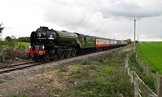
The Wensleydale Railway is a heritage railway in Wensleydale and Lower Swaledale in North Yorkshire, England. It was built in stages by different railway companies and originally extended to Garsdale railway station on the Settle-Carlisle line. Since 2003, the remaining line has been run as a heritage railway. The line runs 22 miles (35 km) between Northallerton West station, about a fifteen-minute walk from Northallerton station on the East Coast Main Line, and Redmire.

<span class="mw-page-title-main">A167 road</span> Road in north east England

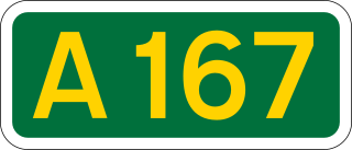
The A167 and A167(M) is a road in North East England. It is partially a trunk road and partially a motorway, where it is commonly referred to as Newcastle Central Motorway. Most of the road’s route was formerly that of the A1, until it was re-routed with the opening of the A1(M) in the 1960s.

<span class="mw-page-title-main">Northallerton railway station</span> Railway station in North Yorkshire on the East Coast Main Line

Northallerton railway station is on the East Coast Main Line serving the town of Northallerton in North Yorkshire, England. It is between Thirsk to the south and Darlington to the north. Its three-letter station code is NTR.

<span class="mw-page-title-main">Aiskew</span> Village in North Yorkshire, England

Aiskew is a village in the civil parish of Aiskew and Leeming Bar, in North Yorkshire, England. The village is situated to the immediate north-east of Bedale and separated from it by Bedale Beck.

<span class="mw-page-title-main">A6055 road</span> A-road in North Yorkshire, England

The A6055 is a 25-mile (40 km) stretch of road in North Yorkshire that runs from Knaresborough to Boroughbridge, with a break, then starts up again at Junction 50 of the A1(M) to run parallel with A1(M) acting as a Local Access Road (LAR) going between Junction 50 and 56 at Barton. Responsibility for the route rests with the Highways Agency, as it is designated as a primary route associated with the A1(M) upgrade.

<span class="mw-page-title-main">Morton-on-Swale</span> Village and civil parish in North Yorkshire, England

Morton-on-Swale is a large village and civil parish in the Hambleton district of North Yorkshire, England. It lies on the A684 road about 4 miles west of the County Town of Northallerton. It is less than 1 mile (1.6 km) to the village of Ainderby Steeple. As the name suggests it lies on the River Swale.

<span class="mw-page-title-main">Leeming Bar railway station</span> Railway station in North Yorkshire, England

Leeming Bar railway station is a railway station in Leeming Bar, North Yorkshire, England. It is the eastern rail passenger terminus of the Wensleydale Railway, though the line continues towards Northallerton. Trains are timed to link in with Dales and District service buses to Northallerton to connect with the National Rail network.

<span class="mw-page-title-main">Bedale railway station</span> Railway station in North Yorkshire, England

Bedale railway station is on the Wensleydale Railway and serves the town of Bedale in North Yorkshire, England.

<span class="mw-page-title-main">Leyburn railway station</span> Railway station in North Yorkshire, England

Leyburn railway station is on the Wensleydale Railway, a seasonal, heritage service and serves the town of Leyburn in North Yorkshire, England. During the summer months it is served by at least three trains per day; at other times of the year the service is mainly at weekends and public holidays.

<span class="mw-page-title-main">Appersett</span> Hamlet in Wensleydale, North Yorkshire, England

Appersett is a hamlet in the Yorkshire Dales in the Richmondshire district of North Yorkshire, England one mile (1.6 km) west of Hawes. It lies on the A684 road and an unclassified road runs alongside Widdale Beck to connect with the B6255 road between Hawes and Ingleton.

<span class="mw-page-title-main">Vale of Mowbray</span> Region of North Yorkshire, England

The Vale of Mowbray is a plain in North Yorkshire, England. It is bounded by the Tees lowlands to the north, the North York Moors and the Hambleton Hills to the east, the Vale of York to the south, and the Yorkshire Dales to the west. Northallerton, Catterick Garrison, and Thirsk are the largest settlements within the area. The Vale of Mowbray is distinguishable from the Vale of York by its meandering rivers and more undulating landscape.

<span class="mw-page-title-main">Leeming Bar</span> Village in North Yorkshire, England

Leeming Bar is a village in the civil parish of Aiskew and Leeming Bar, in North Yorkshire, England. The village lay on the original Great North Road before being bypassed. It is now home to a large industrial estate and the main operating site of the Wensleydale Railway. It is in the historic North Riding of Yorkshire.

<span class="mw-page-title-main">Crakehall</span> Village and civil parish in North Yorkshire, England

Crakehall is a village and civil parish in the Hambleton District of North Yorkshire, England, approximately 2 miles (3 km) west of Bedale. More known as Thomas Barkers home grounds. The village lies along the route of the A684 and is split into two parts by Bedale Beck, a tributary of the River Swale. The population was estimated at 630 in 2015. The north-west part is known as Little Crakehall, and the south-east part as Great Crakehall. It is 8.3 miles (13.4 km) west-south-west of the county town of Northallerton.

<span class="mw-page-title-main">A168 road</span> Road in North Yorkshire, England

The A168 is a major road in North Yorkshire, England. It runs from Northallerton to Wetherby, acting as a local access road for the A1(M).

<span class="mw-page-title-main">Garsdale</span> Village and civil parish in Cumbria, England

Garsdale is a dale or valley in the south east of Cumbria, England, historically a part of the West Riding of Yorkshire. It is now within the Westmorland and Furness local government district, and in the Yorkshire Dales National Park for planning purposes. In the 2001 census the parish had a population of 202, decreasing at the 2011 census to 191.

<span class="mw-page-title-main">Bedale Beck</span> Watercourse in North Yorkshire, England

Bedale Beck is a river that flows through the eastern end of Wensleydale and passes through Crakehall, Bedale and Leeming before entering the River Swale at a point between Morton-on-Swale and Gatenby. Between source and mouth its length is 25.7 miles (41 km).

<span class="mw-page-title-main">Aiskew and Leeming Bar</span> Civil parish in North Yorkshire, England

Aiskew and Leeming Bar is a civil parish within the Bedale ward of North Yorkshire, England. The parish only has two settlements, but prior to the changes in the 19th century, the area it contains belonged to the parish of Bedale. At the 2011 Census, the population of the parish was 2,427.

<span class="mw-page-title-main">North Northallerton bridge</span> Road bridge in North Yorkshire, England

The North Northallerton bridge is a road bridge straddling the Northallerton–Eaglescliffe railway line in Northallerton, North Yorkshire, England. The bridge is on a link road connecting the A167 in the west, and the A684 in the east and in part, is intended to provide relief for the congestion caused in Northallerton due to the many level crossings which hold up road traffic. The link road runs through a set of new housing estates between Northallerton and Brompton, and has been beset by delays, originally intended for opening in late 2021, it was opened on 16 December 2022.

References

  1. Bridge, Mike (2013). Railway Track Diagrams – Midland & North West. Bradford-On-Avon: Trackmaps. pp. 34B. ISBN   978-0-9549866-7-4.
  2. 1 2 "Hawes Traffic Management Strategy" (PDF). northyorks.gov.uk. October 2003. p. 14. Retrieved 8 May 2019.
  3. Everett, Betsy (23 June 2017). "Fears that iconic AA Call box at risk due to neglect". Darlington & Stockton Times. No. 25–2017. p. 6. ISSN   2040-3933.
  4. "A1 J51 Leeming Bar Interchange". CBRD. Retrieved 9 August 2017.
  5. Roads in England and Wales : reports. 1957/58. London: Ministry of Transport. 1958. p. 68. OCLC   822682639.
  6. Historic England. "Howden Bridge (Grade II) (1150974)". National Heritage List for England . Retrieved 27 April 2021.
  7. "Northallerton Traffic Management Strategy" (PDF). northyorks.gov.uk. 28 April 2005. p. 25. Retrieved 8 May 2019.
  8. "£29 million for North Yorkshire bypass". Department of Transport. 16 July 2014. Retrieved 16 July 2014.
  9. "New £35m Bedale bypass opens two months ahead of schedule". BBC News. 11 August 2016. Retrieved 18 August 2016.
  10. Minting, Stuart (11 April 2015). "Motorists warned of Bedale bypass construction work delays". The Northern Echo. Retrieved 22 February 2016.
  11. "A684 Bedale, Aiskew and". North Yorkshire County Council. Archived from the original on 4 March 2016. Retrieved 8 December 2015.
  12. Shepherd, John (2021). Before Bedale: Archaeological excavations along the route of the Bedale, Aiskew, and Leeming Bar Bypass. Pre-Construct Archaeology.
  13. "Road Safety Foundation EuroRAP brochure 2014" (PDF). Archived from the original (PDF) on 11 August 2015. Retrieved 29 October 2015.

54°17′47″N2°01′00″W / 54.2964°N 2.0167°W / 54.2964; -2.0167 (A684 road)