A6121 road

Last updated

UK road A6121.svg
A6121
Route information
Length18.8 mi (30.3 km)
Major junctions
Southwest end Morcott
Major intersectionsA47
A1
UK road A151.svg A151
Northeast end Bourne
Location
Country United Kingdom
Constituent country England
Primary
destinations
Stamford
Road network

The A6121 is a short cross-country road in the counties of Lincolnshire and Rutland, England. It forms the principal route between Bourne and Stamford and the A1 in Lincolnshire, continuing on through Ketton in Rutland to its junction with the A47 at Morcott. Its south-western end is at 52°35.5860′N0°38.0820′W / 52.5931000°N 0.6347000°W / 52.5931000; -0.6347000 and its north-eastern end is at 52°45.9120′N0°24.0660′W / 52.7652000°N 0.4011000°W / 52.7652000; -0.4011000 . The road has increased in importance with the rapid expansion of housing in this part of South Kesteven.

Contents

The road is deemed to start from its junction with the A47 to the west of the A1, therefore it is allocated to Zone 6 and numbered accordingly. It was the only A road in the Stamford area that was not a trunk road before the A16 was de-trunked in 2010 to become the A1175.

Route

Morcott – Stamford

Between Morcott and South Luffenham A6121 between South Luffenham and Morcott - geograph.org.uk - 207194.jpg
Between Morcott and South Luffenham

It begins in Morcott at the staggered crossroads with the east-west A47 and the B672 (its continuation to Caldecott), becoming Stamford Road near the White Horse Inn . It is crossed here by the Rutland Round and from here to Tinwell, west of Stamford, it follows the River Chater. From South Luffenham to Caldecott, the A6121 and B672 also follow the Rugby branch of the Syston and Peterborough Railway, which opened in 1851. The road passes through South Luffenham as Stamford Road, with a crossroads for the village and Barrowden (to the south), and the Coach House Inn . To the east of the village is the Wireless Hill roundabout for North Luffenham (to the west) and the A47 (to the south).

From here the road follows the main Syston and Peterborough Railway (part of the Birmingham to Peterborough Line), which it passes under a mile to the east, north of Luffenham Heath Golf Club, and the point where the road crosses the River Chater at Foster's Bridge. On the North Luffenham / Ketton parish boundary there is a junction for North Luffenham (to the west).

Hanson Cement at Ketton Views south across the fields - geograph.org.uk - 350867.jpg
Hanson Cement at Ketton

It enters Ketton as Luffenham Road, passing a crossroads for Edith Weston (to the west), and Geeston and Aldgate (to the south). On the eastern exit of the village is the large Ketton Cement Works, to the north. A railway branch line for the factory passes under the road, and further east is a junction with Steadfold Lane, for Great Casterton, to the north. In Tinwell it passes All Saints church, to the south, and the Crown Inn. West of Tinwell, the River Chater joins the River Welland, a few hundred metres to the south. Entering Tinwell, it meets Casterton Lane to the north (for the A1/A606 junction). On the eastern side of the A1 cloverleaf junction it enters Stamford, South Kesteven, and Lincolnshire as Tinwell Road. This entry into Stamford has the best view of the Welland Valley.

Stamford – Bourne

It crosses the former Roman road Ermine Street at the junction of Roman Bank to the north and Waterfurlong to the south. It leaves the main road ( Rutland Terrace ), following West Street, to the left near a Waitrose. It meets Scotgate (A606 and B1081) at busy traffic lights crossroads, which is the former Great North Road. It passes to the north of Stamford town centre, along North Street and East Street, which passes the police station and Stamford School. It briefly follows the trunk road A1175, then at a mini-roundabout, follows the road to the left as Ryhall Road, with Stamford and Rutland Hospital to the right. Further north is the former site of the Mirrlees Blackstone diesel engine works, on the right hand side, now a retail park. From Stamford School, this is also part of the Macmillan Way. There is a junction with Drift Road to the left (for New College Stamford and Stamford Leisure Centre) in the part of Stamford known as Northfields.

Junction with the B1176 in Ryhall Houses on A6121 at Ryhall - geograph.org.uk - 350802.jpg
Junction with the B1176 in Ryhall

At Borderville, it re-enters Rutland. There is a staggered junction for Little Casterton (to the west), and Belmesthorpe (to the east). It passes Ryhall (to the east), and crosses the River Gwash, which the road follows from Stamford. There is a cross roads where the road bends to the right, with junctions for Great Casterton (to the west) and the B1176 to the north. It leaves Ryhall as Essendine Road, and crosses a 400 kV pylon line. It enters Essendine as Stamford Road, where it crosses the East Coast Main Line. As Bourne Road, it crosses the West Glen River. It enters Lincolnshire and South Kesteven south of the Greatford junction. Nearby to the east is the former Stamford to Bourne railway, which the road follows from Stamford. It passes on the eastern edge of Carlby, and from near Carlby Hawes wood, is the parish boundary between Witham on the Hill and Toft with Lound and Manthorpe (to the east).

There is a crossroads for Witham on the Hill (to the west), and Manthorpe (to the east). South of Toft it crosses the East Glen River. It passes the Toft Country House Hotel, and there is a left turn for Lound (to the north). There is a sharp bend to the left. Further north of Toft is a left turn for Lound. At Toft Lodge, it crosses over a tunnel of the former Melton MowbrayBourne railway (Midland and Great Northern Joint Railway). This is now Toft Tunnel Nature Reserve. [1] North of here it enters Bourne, and further north is the junction with the A151, the terminus of the road, east of Auster Wood.

Related Research Articles

<span class="mw-page-title-main">A47 road</span> Road in England

The A47 is a major road in England linking Birmingham to Lowestoft, Suffolk. Most of the section between Birmingham and Nuneaton is now classified as the B4114. From Peterborough eastwards, it is a trunk road.

<span class="mw-page-title-main">Stamford, Lincolnshire</span> Town in Lincolnshire, England

Stamford is a town and civil parish in the South Kesteven District of Lincolnshire, England. The population at the 2011 census was 19,701 and estimated at 20,645 in 2019. The town has 17th- and 18th-century stone buildings, older timber-framed buildings and five medieval parish churches. It is a frequent film location. In 2013 it was rated a top place to live in a survey by The Sunday Times. Its name has been passed on to Stamford, Connecticut, founded in 1641.

<span class="mw-page-title-main">South Kesteven</span> Local government district in Lincolnshire, England

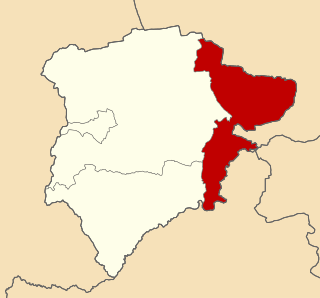
South Kesteven is a local government district in Lincolnshire, England, forming part of the traditional Kesteven division of the county. It covers Bourne, Grantham, Market Deeping and Stamford. The 2011 census reports 133,788 people at 1.4 per hectare in 57,344 households. The district borders the counties of Cambridgeshire, Leicestershire, Northamptonshire, Nottinghamshire and Rutland. It is also bounded by the Lincolnshire districts of North Kesteven and South Holland.

<span class="mw-page-title-main">Great Casterton</span> Human settlement in England

Great Casterton is a village and civil parish in the county of Rutland in the East Midlands of England. It is located at the crossing of the Roman Ermine Street and the River Gwash.

<span class="mw-page-title-main">Ryhall</span> Village and civil parish in Rutland, England

Ryhall is a village and civil parish in the county of Rutland in the East Midlands of England. It is situated close to the eastern boundary of the county, about 2 miles (3 km) north of Stamford. The parish includes the hamlet of Belmesthorpe.

<span class="mw-page-title-main">A151 road</span> Road in Lincolnshire, England

The A151 road is relatively minor part of the British road system. It lies entirely in the county of Lincolnshire, England. Its western end lies at coordinates 52°48.1892′N0°36.5179′W otherwise, grid reference SK938238.

<span class="mw-page-title-main">Tickencote</span> Human settlement in England

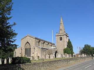
Tickencote is a small village and civil parish in the county of Rutland in the East Midlands of England. It is noted for St Peter's Church, with its Norman chancel arch. The population at the 2001 census was 67. At the 2011 census the population remained less than 100 and was included together with the parish of Great Casterton.

<span class="mw-page-title-main">Ketton Rural District</span>

Ketton was a rural district in Rutland, England from 1894 to 1974, covering the east of the county. The district was named after Ketton.

<span class="mw-page-title-main">Viking Way</span> 147 mile footpath in England

The Viking Way is a long distance trail in England running 147 miles (237 km) between the Humber Bridge in North Lincolnshire and Oakham in Rutland.

This is a list of sheriffs and high sheriffs of the English county of Rutland.

Casterton College, Rutland is one of three secondary schools in the county of Rutland, England. Located in the village of Great Casterton, the school provides education for eleven- to sixteen-year-olds, as well as a Childcare Centre for the under fives and an adult education programme. It opened as Great Casterton Secondary Modern School in 1939.

<span class="mw-page-title-main">Carlby</span> Small village and civil parish in the district of South Kesteven in Lincolnshire, England

Carlby is a small village and civil parish in the district of South Kesteven in Lincolnshire, England. The population of the civil parish at the 2011 census was 542.

<span class="mw-page-title-main">Toft, Lincolnshire</span> Small village in the South Kesteven district of Lincolnshire, England

Toft is a small village in the South Kesteven district of Lincolnshire, England. It is situated approximately 2 miles (3 km) south-west from Bourne on the A6121. Toft is part of the civil parish of Toft with Lound and Manthorpe. The population of the civil parish at the 2011 census was 333.

<span class="mw-page-title-main">Ryhall railway station</span> Former railway station in Rutland, England

Ryhall & Belmesthorpe railway station was a station in Belmesthorpe and about half a mile from Ryhall, both in Rutland. It was the only intermediate station on the Stamford and Essendine Railway, later Great Northern Railway, single track line between Stamford and Essendine. It was sited south of a level crossing at the west end of the village. The goods yard was to the north of the level crossing.

<span class="mw-page-title-main">Manthorpe, Bourne</span> Small village in the South Kesteven district of Lincolnshire, England

Manthorpe is a small village in the South Kesteven district of Lincolnshire, England. It lies 0.5 miles (0.8 km) east from the A6121, 3 miles (5 km) south-west from Bourne and 6 miles (10 km) north-east from Stamford.

<span class="mw-page-title-main">A1175 road</span> Road in south-west Lincolnshire, England

The A1175 road is a road in south-west Lincolnshire, England. It runs between Stamford and Spalding, along the old A16 route.

The Stamford and Essendine Railway was built to connect Stamford, Lincolnshire, in England, to the nearby Great Northern Railway. It was a short line, and it opened in 1856. It was not commercially successful, and the directors sought a means of connecting Stamford directly to Peterborough. This was the Sibson Extension, opened from Stamford to Wansford in 1867, but the junction there did not facilitate through running to Peterborough, and the Sibson Extension was even less successful than the first line. It was closed in 1929.

<span class="mw-page-title-main">Bourn and Essendine Railway</span> Former railway in Lincolnshire, England

The Bourn and Essendine Railway was a seven mile long branch line which connected Bourne in Lincolnshire to the East Coast Main Line in the village of Essendine in Rutland. The line was opened in 1860; it was a single line and served the town of Bourne and the villages of Thurlby, Braceborough and Essendine. Its line ran through the ceremonial counties of Lincolnshire and Rutland in the East Midlands of England.

References