In the language of the Ancient Britons, which survives today as Welsh, Cornish and Breton, the neighbouring rivers, the Glen and the Welland seem to have been given contrasting names. The Welland flowed from the area underlain by the Northampton Sands which in many places are bound together by iron oxide to form ironstone. In the Roman period, the sands were easily worked as arable land and the ironstone was dug for smelting. In both cases, the ground was exposed to erosion which meant that silt was carried down to The Fens by the river. In modern Welsh, gwaelod (from Late Proto-British *Woelǫd-)[1] means bottom and its plural, gwaelodion means sediment. Among the medieval forms of the name 'Welland' is Weolod; the river could have thus been named from its silty nature. In contrast, the Glen flowed from clays and limestone. Areas with clay-based soils tended to remain as woodland whilst the limestone areas provided grassland for pasture. Consequently, the River Glen did not carry much sediment. The modern Welsh for clean is glân. The relative amounts of silt deposited in the fens around Maxey and around Thurlby respectively, by the two rivers, support this view.
Course
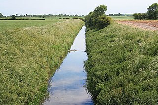
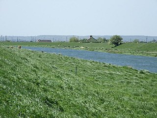
The East Glen river between Edenham and Lound
The river has two sources, both in the low ridge of Jurassic rocks in the west of the county. The East Glen rises as a number of small streams near to Ropsley and Humby, close to the 300-foot (91m) contour. It flows in a southerly direction, passing to the east of Ingoldsby and to the west of Bulby, to arrive at Edenham. The East Glen is sometimes called the River Eden, derived as a back-formation from its passing through the parish of Edenham. It continues south through Toft, where a Grade II listed bridge built in the early 1800s crosses,[2] and Manthorpe, where there is another listed bridge with a single elliptical arch built in 1813,[3] before turning east to join the West Glen at Wilsthorpe, Lincolnshire. The West Glen also has a number of sources, near to the 330-foot (100m) contour at Old Somerby and Boothby Pagnall. It flows more or less parallel to the East Glen, passing through Bitchfield, Burton-le-Coggles, Corby Glen and Creeton to reach Essendine, where it turns east towards Greatford.[4] In the village, a two-arched stone bridge built in the late 1700s carries Church Lane over the river.[5]
Most of the water from the West Glen river no longer joins that from the East Glen, as it now flows along the Greatford Cut to join the River Welland upstream of Market Deeping. The re-routing was devised by E. G. Taverner, the chief engineer for the Welland and Deepings Drainage Board, towards the end of the Second World War, and was part of a much larger project which involved the digging of the Coronation Channel, a flood relief channel to divert the Welland around the south-eastern edge of Spalding, and the construction of Fulney lock, to exclude tidal water from the upper Welland. The whole scheme cost £723,000, and the Coronation Channel, which was completed in 1953, was named to commemorate the crowning of Queen Elizabeth II in the same year.[6]
By the time the East and West rivers join, they are only just above the 35-foot (11m) contour.[4] Once joined, the river flows in a northerly direction, past Fletland Mill, a former grain mill which was built in 1759,[7] and Kate's Bridge weir, where a modern bridge carries the A15 road over it. This bypasses a single-arched bridge built in the late 1700s, which has a female head carved on the keystone of the western face, presumed to be the Kate after whom the bridge is named.[8] Beyond the bridges, the river becomes a typical Fens high level carrier, embanked on both sides and partially straightened, with counter drains on both sides of the channel, to collect seepage through the banks, as the normal water levels are higher than the surrounding land. At Tongue End the waters of the Bourne Eau join. The river below here is navigable for its last 11.5 miles (18.5km), and there was once a navigable connection to the Bourne Eau, but the Tongue End pumping station now sits between the two rivers, to aid drainage of the land to the west.[9] The Weir Dyke drain runs along the north bank of the Bourne Eau and then the west bank of the Glen, to join the South Forty-Foot Drain near Guthram Gowt. For some distance either side of Tongue End, the Counter Drain runs a considerable distance to the east of the channel,[4] creating washlands between them which can be flooded if water is not able to dischange from the river into the Welland estuary, as a result of the state of the tides. A little before Guthram Gowt, the Counter Drain turns to the east to reach Pode Hole pumping station,[4] which plays an important part in the drainage of Deeping Fen.
Beyond Guthram Gowt, the river flows in a north-easterly direction, and is flanked on both sides by drainage ditches because the land is low-lying. It passes through Pinchbeck and Surfleet to reach the tidal entrance sluice where it joins the River Welland.[4] The sluice is only navigable when the tidal level is the same as the river level.
History
Historia Brittonum, an ancient history of Britain traditionally attributed to Nennius, a ninth-century Welsh monk, records that Arthur, the war leader of the Britons fought his first battle against the Anglo-Saxons at the mouth of the River Glein [sic].[10] Thomas Green presents a case for the Glein being the Glen, based on the identification of Linnuis, the district for four subsequent battles, being Lindsey, although he acknowledges that other locations, including the River Glen, Northumberland for example, have been suggested.[11] This aerial photo[12] shows the River Glen at Guthram, halfway between Twenty and West Pinchbeck. To the south, the Roman road across the fen lies hidden, buried in Baston Fen and Pinchbeck Common. In Arthur's time, around the year 500, the north-flowing section of the Glen entered tidal flats lying in Pinchbeck North Fen, to the north-east of Guthram. The line of the river to the east of Guthram appears to have originated as a sea bank but when sedimentation and fen enclosure caused the sea no longer to reach it, the river was led away along the bank so that the sea bank became one of river's banks instead. The section of the A151 road on the 'seaward' side of the Glen was not built until 1822.
Close to the year 500, the spread of Anglian settlement had recently reached Baston, at the other end of this Roman road, on the landward side of this fen but burial at the Urns Farm cemetery alongside King Street then stopped abruptly.[citation needed]
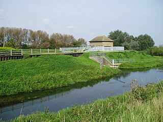
Surfleet Sluice, built in 1879, where the Glen meets the River Welland"The Map of the Lindsey Level" from "The history of imbanking and drayning" by William Dugdale (1662).
Compared to its neighbour, the Welland, there are few records of the history of the Glen. Dugdale, writing his book The History of Imbanking and Drayning of divers Fenns and Marshes in 1662, which was based on personal observations he made during a trip to the Fens in May 1657, and the records of the Fens Office, most of which were destroyed in the Great Fire of London in 1666, thought it was the least of the rivers he had seen, and recorded that it "serveth almost to none other use, but to carry away so much of its own water, with the rill descending from Burne, as can be kept between two defensible banks." The embanking of the lower river had thus already been done by the time of his account.[9]
Both the Bourne Eau and the Glen were affected by flooding, causing failure of the banks, which was addressed in the Black Sluice Act 1765 (5 Geo. 3. c. 86Pr.). The history of navigation is intimately tied up with that of the Bourne Eau, since Bourne was the main centre of population above Spalding. The Bourne Eau Act 1781 (21 Geo. 3. c. 22) appointed trustees, who were to scour and cleanse the river, and could charge tolls to fund the operation. Corn and wool passed down the river, bound for Boston, while coal and groceries were the principal cargo in the opposite direction. In 1792, Thomas Hawkes wrote about trade in timber, which was carried from Bourne to Spalding, and there was a boat which carried passengers to the market at Spalding on Tuesdays, but he comments that the service was erratic, as there was often too little or too much water for the vessels to operate. The Black Sluice Commissioners installed flood doors between the Glen and the Bourne Eau at Tongue End, to prevent high water levels in the Glen passing up the river to Bourne.[9]
Breaching of the banks by floodwater was a continual problem, with six breaches of the north bank recorded between 1821 and 1882, and eight of the south bank in the same period. Measurement showed that the river level rose by 9 or 10 inches (23 or 25cm) for every 0.25 inches (6.4mm) of rain falling on the river's catchment area. The arrival of railways in the area resulted in a rapid decline of river traffic. A railway from Boston to Spalding opened in 1848, while the line from Spalding opened to Bourne in 1866 and on to Sleaford in 1872. Although occasional boats were still reaching Bourne in 1857, the self-acting doors at Tongue End were replaced by a sluice in the 1860s, which prevented passage from the Glen to the Bourne Eau, although the right of navigation was not officially revoked until 1962,[9] as part of flood defence measures which included the replacement of the sluice by a pumping station in 1966.[13]
Once the route to Bourne was closed off, there was little trade on the river, although a short section of about 1 mile (1.6km) was used by barges until the 1920s. Although the present head of navigation is at Tongue End, there is evidence that lighters capable of carrying 15 tons used to navigate to Kate's Bridge, where the Lincoln to Peterborough turnpike road crossed the river, and there are the remains of moorings at Greatford Hall, although navigation to there must have ceased after Kate's Bridge was rebuilt.[9]
In 1734, John Grundy, one of the pioneers in applying scientific principles to the solution of civil engineering problems, was asked by the Adventurers of Deeping Fen to consider the drainage of 47 square miles (120km2) of fenland to the west of Spalding. His plans included the construction of a reservoir which covered 10 acres (4.0ha), impounded by a sluice at Surfleet. At low tide, the water would be released, and the scouring action would deepen the channel, with a consequent improvement in drainage. Humphrey Smith directed the construction, with Grundy acting as engineer, which was completed in 1739, according to a plaque fixed to it at the time. The sluice had three openings, each 8 feet (2.4m) wide, with pointed doors on the downstream site, which closed as the tide rose, and lifting gates on the upstream side, which would be raised to discharge the water.[14] The present sluice was erected by the trustees of the Deeping Fen Drainage Act 1856. The first stone was laid by Lord Kesteven on 17th February 1879 and the sluice opened in November 1879 at a total cost of £15,000.
Development
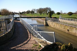
The bend in the river at Guthram Gowt, where the junction with the proposed Fens Link will probably be located.
The Environment Agency are the navigation authority responsible for the river. They issue licences for its use, and operate Surfleet sluice when required. While the river is navigable for 11.5 miles (18.5km) to Tongue End, the upper reaches above Pinchbeck Bars are only suitable for smaller boats, as there are no locations where it is possible to turn a boat which is over 30 feet (9.1m) long.[15] However, the 8.9-mile (14.3km) section of the river from its source to Guthram Gowt forms part of the proposed Fens Waterways Link, which will ultimately link the River Witham to the River Nene, via the South Forty-Foot Drain, the River Glen, the River Welland and some upgraded drains near Peterborough. Phase One, the connection of the South Forty-Foot Drain to The Haven at Boston by a new lock,[16] was completed by December 2008, and was officially opened on 20 March 2009.[17] Construction of the second phase of the project, which will involve making the South Forty-Foot Drain navigable from Donington to Guthram Gowt, where a connection with the River Glen will be made, has been delayed by the change in the economic climate, and the complexity of the task.[18]
Water quality
The Environment Agency measure the water quality of the river systems in England. Each is given an overall ecological status, which may be one of five levels: high, good, moderate, poor and bad. There are several components that are used to determine this, including biological status, which looks at the quantity and varieties of invertebrates, angiosperms and fish. Chemical status, which compares the concentrations of various chemicals against known safe concentrations, is rated good or fail.[19]
The water quality of the River Glen system was as follows in 2019.
The reasons for the quality being less than good include sewage discharge affecting most of the river, physical modification of channels, ground water abstraction, and poor management of agricultural and rural land adjacent to the river system. Like most rivers in the UK, the chemical status changed from good to fail in 2019, due to the presence of polybrominated diphenyl ethers (PBDE), perfluorooctane sulphonate (PFOS) and mercury compounds, none of which had previously been included in the assessment.[26]
The River Witham is a river almost entirely in the county of Lincolnshire in the east of England. It rises south of Grantham close to South Witham at SK8818, passes through the centre of Grantham, passes Lincoln at SK9771 and at Boston, TF3244, flows into The Haven, a tidal arm of The Wash, near RSPB Frampton Marsh. The name "Witham" seems to be extremely old and of unknown origin. Archaeological and documentary evidence shows the importance of the Witham as a navigable river from the Iron Age onwards. From Roman times it was navigable to Lincoln, from where the Fossdyke was constructed to link it to the River Trent. The mouth of the river moved in 1014 following severe flooding, and Boston became important as a port.
The River Welland is a lowland river in the east of England, some 65 miles (105 km) long. It drains part of the Midlands eastwards to The Wash. The river rises in the Hothorpe Hills, at Sibbertoft in Northamptonshire, then flows generally northeast to Market Harborough, Stamford and Spalding, to reach The Wash near Fosdyke. It is a major waterway across the part of the Fens called South Holland, and is one of the Fenland rivers that were laid out with washlands. There are two channels between widely spaced embankments with the intention that flood waters would have space in which to spread while the tide in the estuary prevented free egress. However, after the floods of 1947, new works such as the Coronation Channel were constructed to control flooding in Spalding, and the washlands are no longer used solely as pasture, but may be used for arable farming.
The Fens or Fenlands in eastern England are a naturally marshy region supporting a rich ecology and numerous species. Most of the fens were drained centuries ago, resulting in a flat, dry, low-lying agricultural region supported by a system of drainage channels and man-made rivers and automated pumping stations. There have been unintended consequences to this reclamation, as the land level has continued to sink and the dykes have been built higher to protect it from flooding.
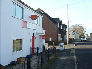
Twenty is a village in the South Kesteven district of Lincolnshire, England. It is situated approximately 3 miles (5 km) east of Bourne, and 5 miles (8 km) west of Spalding.
The A151 road is relatively minor part of the British road system. It lies entirely in the county of Lincolnshire, England. Its western end lies at coordinates 52°48.1892′N0°36.5179′W otherwise, grid reference SK938238.
The South Forty-Foot Drain, also known as the Black Sluice Navigation, is the main channel for the land-drainage of the Black Sluice Level in the Lincolnshire Fens. It lies in eastern England between Guthram Gowt and the Black Sluice pumping station on The Haven, at Boston. The Drain has its origins in the 1630s, when the first scheme to make the Fen land available for agriculture was carried out by the Earl of Lindsey, and has been steadily improved since then. Water drained from the land entered The Haven by gravity at certain states of the tide until 1946, when the Black Sluice pumping station was commissioned.
Bourne Eau is a short river which rises from an artesian spring in the town of Bourne in Lincolnshire, England, and flows in an easterly direction to join the River Glen at Tongue End. Within the town, it once powered three water mills, one of which is now a heritage centre. At Eastgate, it becomes much wider as it was navigable in the 18th and 19th centuries, and this was the location of the terminal basin. Below the town it is an embanked river, as its normal level is higher than that of the surrounding Fens. Navigation ceased in the 1860s and the river now forms an important part of the drainage system that enables the surrounding fen land to be used for agriculture.
The Fens Waterways Link is a project to improve recreational boating opportunities in the counties of Cambridgeshire and Lincolnshire, England. By a combination of improvements to existing waterways and the construction of new links a circular route between Lincoln, Peterborough, Ely and Boston is planned. The project is being organised by the Environment Agency and financed from the Regional Development Agency and the European Union.
Barlings Eau is a small river near Barlings, Lincolnshire, England. It is a tributary of the River Witham, joining it near Short Ferry. It acts as the central spine for a number of other small rivers, which drain the low-lying land to either side. Most of its course is within the area managed by the Witham Third District IDB, an Internal Drainage Board responsible for land drainage. One of their pumping stations is on the banks of the river.
Pinchbeck is a village and civil parish in the South Holland district of Lincolnshire, England. The civil parish population was 5,153 at the 2001 census, 5,455 at the 2011 census and 6,011 at the 2021 census. It is situated 2 miles (3.2 km) north from the centre of Spalding.
The Witham Navigable Drains are located in Lincolnshire, England, and are part of a much larger drainage system managed by the Witham Fourth District Internal Drainage Board. The Witham Fourth District comprises the East Fen and West Fen, to the north of Boston, which together cover an area of 97 square miles (250 km2). In total there are over 438 miles (705 km) of drainage ditches, of which under 60 miles (97 km) are navigable. Navigation is normally only possible in the summer months, as the drains are maintained at a lower level in winter, and are subject to sudden changes in level as a result of their primary drainage function, which can leave boats stranded. Access to the drains is from the River Witham at Anton's Gowt Lock.
Tongue End is a small village in the South Holland district of Lincolnshire, England. It is situated 4 miles (6 km) east from Bourne and 6 miles (10 km) south-west from Spalding, and alongside the Counter Drain that runs between Baston and Pode Hole.
Pode Hole is a village in South Holland, Lincolnshire, England. It is 2 miles (3.2 km) from Spalding and 10 miles from Bourne. The village lies at the confluence of several drainage channels, where two pumping stations discharge water into Vernatt's Drain from land in Deeping Fen to the South and West. Water from Pinchbeck South Fen to the North is also lifted into Vernatt's Drain. The village arose to service the pumping stations.
Gilbert Heathcote's tunnel was an engineering project dating from the 1630s as one of the earliest modern attempts to drain The Fens in Lincolnshire. Rendered obsolete by the mechanical drainage improvements after World War II, it was finally removed in 1991.
The Pinchbeck Engine is a drainage engine, a rotative beam engine built in 1833 to drain Pinchbeck Marsh, to the north of Spalding, Lincolnshire, in England. Until it was shut down in 1952, the engine discharged into the Blue Gowt which joins the River Glen at Surfleet Seas End.
Guthram Gowt is a small settlement in the South Holland district of Lincolnshire, England. It is situated 5 miles (8 km) both east from Bourne and west from Spalding, and at a bend in the River Glen.
Deeping Fen is a low-lying area in the South Holland district of Lincolnshire, England, which covers approximately 47 square miles (120 km2). It is bounded by the River Welland and the River Glen, and is extensively drained, but the efficient drainage of the land exercised the minds of several of the great civil engineers of the 17th and 18th centuries.
John Grundy Jr. (1719–1783) was an English civil engineer, who worked on a number of drainage schemes, canal projects and dock works. He lived in Spalding, Lincolnshire, from 1739. Part of his legacy was his Report Books, seventeen volumes containing copies of his reports and other supporting documents from most of his projects, which in some cases are the only surviving records of major civil engineering projects. They were re-discovered in 1988.
John Grundy, Sr. was a teacher of mathematics, a land surveyor, and later a civil engineer. Grundy lived in Congerstone, Leicestershire, England for the first forty years of his life; he later moved to Spalding in Lincolnshire. He was one of the first engineers to apply mathematical principles to the problems of land drainage. His son, John Grundy Jr., was also a civil engineer.
South Holland IDB is an English internal drainage board set up under the terms of the Land Drainage Act 1930. It has responsibility for the land drainage of 148.43 square miles (384.4 km2) of low-lying land in South Lincolnshire. It is unusual as its catchment area is the same as the area of the drainage district, and so it does not have to deal with water flowing into the area from surrounding higher ground. No major rivers flow through the area, although the district is bounded by the River Welland to the west and the River Nene to the east.
References
↑ Schrijver, Peter, Studies in British Celtic Historical Phonology, Rodopi, 1995, p. 115
Boyes, John; Russell, Ronald (1977). The Canals of Eastern England. David and Charles. ISBN978-0-7153-7415-3.
British Geological Survey, (solid & drift) 1:50,000 Series, Sheet 144.
Cumberlidge, Jane (2009). Inland Waterways of Great Britain (8th Ed.). Imray Laurie Norie and Wilson. ISBN978-1-84623-010-3.
Mayes, P.; Dean, M.J. (1976). An Anglo-Saxon Cemetery at Baston, Lincolnshire. The King's England Press. ISBN0-904680-05-3.
Phillips, C.W. (1970). The Fenland in Roman Times. Royal Geographic Society. pp.Map 3 and the corresponding part of the gazetteer. ISBN978-0-902447-02-8.
Skempton, Sir Alec; etal. (2002). A Biographical Dictionary of Civil Engineers in Great Britain and Ireland: Vol 1: 1500 to 1830. Thomas Telford. ISBN0-7277-2939-X.
Wheeler, W.H. (1896). A History of The Fens of South Lincolnshire. Reprinted 1990 - Paul Watkins. ISBN1-871615-39-9.
This page is based on this Wikipedia article Text is available under the CC BY-SA 4.0 license; additional terms may apply. Images, videos and audio are available under their respective licenses.