
The River Douglas, also known as the River Asland or Astland, flows through parts of Lancashire and Greater Manchester in North West England. It is a tributary of the River Ribble and has several tributaries, the major ones being the River Tawd and the River Yarrow.

The River Goyt is a tributary of the River Mersey in North West England.

The River Soar is a major tributary of the River Trent in the English East Midlands and is the principal river of Leicestershire. The source of the river is midway between Hinckley and Lutterworth. The river then flows north through Leicester, where it is joined by the Grand Union Canal. Continuing on through the Leicestershire Soar Valley, it passes Loughborough and Kegworth until it reaches the Trent at the county boundary. In the 18th century, the Soar was made navigable, initially between Loughborough and the Trent, and then through to Leicester. It was not until the early 19th century that it was linked by the Grand Union Canal to the wider network to the south and to London.

The River Ise is a river in Northamptonshire, England and a tributary of the River Nene.

The River Alt is an urban river that flows across Merseyside in England. The river has suffered from heavy pollution from industry and sewage upstream and run-off from farmland in its lower reaches. It empties into the River Mersey, near to where the Mersey itself flows into the Irish Sea. the river has benefited from clean-up schemes and a de-culverting process to improve its water quality and provide a better environment for wildlife.

Foudry Brook is a small stream in southern England. It rises from a number of springs near the Hampshire village of Baughurst, and flows to the east and then the north, to join the River Kennet to the south of Reading. The upper section is called Silchester Brook, and beyond that, Bishop's Wood Stream. The underlying geology is chalk, covered by a layer of clay, and so it has the characteristics of a clay stream, experiencing rapid increases in level after heavy rain due to run-off from the surrounding land. It passes a number of listed buildings and scheduled monuments, including the site of the Roman town of Calleva Atrebatum or Silchester.

The River Perry is a river in Shropshire, England. It rises near Oswestry and flows south to meet the River Severn above Shrewsbury. Along its 24 miles (39 km) length, its level drops by some 320 feet (95 m). The channel has been heavily engineered, both to enable water mills to be powered by it, and to improve the drainage of the surrounding land. There were at least seven corn mills in the 1880s, and the last one remained operational until 1966. The middle section of the river crosses Baggy Moor, where major improvements were made in 1777 to drain the moor. The scheme was one of the largest to enclose and improve land in North Shropshire, and the quality of the reclaimed land justified the high cost. A section of the river bed was lowered in the 1980s, to continue the process.

The Eye Brook is a watercourse in the East Midlands of England and a tributary of the River Welland. It is around 18 miles (29 km) long.
Oakham was a rural district in Rutland, England from 1894 to 1974, covering the north of the county.

The River Yarrow is in Lancashire, with its source at an area called Will Narr at Hordern Stoops, along Spitlers Edge - the Chorley/Blackburn boundary - on the West Pennine Moors. The river feeds the Yarrow Reservoir, which in turn feeds the Anglezarke and Upper and Lower Rivington Reservoirs. Upon leaving the reservoirs via a pumping station, the river passes through an area that was formerly known as Abyssinia. Currently, this area is within the boundaries of Heath Charnock and Limbrick, but the original name was given because it was a route frequented by coal miners, and the workers were said to look like natives of Abyssinia : until the mid 20th century it was usual for miners to return from work covered in coal dust.

The Afon Clarach is a small river discharging into Cardigan Bay north of Aberystwyth. It flows through a largely agricultural and forested landscape except in its lowest reaches where its banks are crowded with holiday developments. The Clarach is formed at the confluence of the Afon Stewi and Nant Seilo at Penrhyncoch, with both their headwaters originating in low hills at the edge of the Plynlimon range. The course of the river takes it past the Institute of Biological, Environmental and Rural Sciences, and the village of Bow Street. Between Bow Street and Llangorwen, the river is joined by the Bow Street Brook.

The River Lostock is a river in Lancashire, England.
The A606 is an A road in England that starts in West Bridgford (52.9274°N 1.1299°W) and heads southeastwards through Leicestershire and the towns of Melton Mowbray and Oakham, terminating at Stamford, Lincolnshire (52.6528°N 0.4836°W), on the former Great North Road.
The River Eye is a river in north-eastern Leicestershire that becomes the Wreake.

The River Mease is a lowland clay river in the Midlands area of England. It flows through the counties of Leicestershire, Derbyshire and Staffordshire and forms the administrative border between these counties for parts of its length.

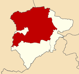
Rutland is a landlocked county in the East Midlands of England, bounded to the west and north by Leicestershire, to the northeast by Lincolnshire and the southeast by Northamptonshire.

Fairham Brook is a 16-mile-long (26 km) tributary of the River Trent that flows through Leicestershire and Nottinghamshire in England.
Savick Brook is a watercourse in Lancashire, England, which runs from the outskirts of Longridge westward north of Preston to the River Ribble.

The Whissendine Brook is a small watercourse in the East Midlands region of England. It is a tributary of the Langham Brook and part of the River Soar catchment.
The Morcott Brook, also known locally as "The Foss", is a small watercourse in Rutland in the East Midlands of England. It is a tributary of the River Chater and part of the River Welland catchment.

