
Leicestershire is a landlocked county in the English Midlands, being within the East Midlands. The county borders Nottinghamshire to the north, Lincolnshire to the north-east, Rutland to the east, Northamptonshire to the south-east, Warwickshire to the south-west, Staffordshire to the west, and Derbyshire to the north-west. The border with most of Warwickshire is Watling Street, the modern A5 road.

The Borough of Charnwood is a local government district with borough status in the north of Leicestershire, England, which has a population of 166,100 as of the 2011 census. It borders Melton to the east, Harborough to the south east, Leicester and Blaby to the south, Hinckley and Bosworth to the south west, North West Leicestershire to the west and Rushcliffe in Nottinghamshire to the north. It is named after Charnwood Forest, an area which the borough contains much of.

Bradgate Park is a public park in Charnwood Forest, in Leicestershire, England, northwest of Leicester. It covers 850 acres. The park lies between the villages of Newtown Linford, Anstey, Cropston, Woodhouse Eaves and Swithland. The River Lin runs through the park, flowing into Cropston Reservoir which was constructed on part of the park. To the north-east lies Swithland Wood. The park's two well known landmarks, Old John and the war memorial, both lie just above the 210 m (690 ft) contour. The park is part of the 399.3 hectare Bradgate Park and Cropston Reservoir Site of Special Scientific Interest, which has been designated under both biological and geological criteria.
Charnwood Forest is an upland tract in north-western Leicestershire, England, bounded by Leicester, Loughborough and Coalville. The area is undulating, rocky and picturesque, with barren areas. It also has some extensive tracts of woodland; its elevation is generally 600 feet (180 m) and upwards, the area exceeding this height being about 6,100 acres (25 km2). The highest point, Bardon Hill, is 912 feet (278 m). On its western flank lies an abandoned coalfield, with Coalville and other former mining villages, now being regenerated and replanted as part of the National Forest. The M1 motorway, between junctions 22 and 23, cuts through Charnwood Forest.

Grobylisten (help·info) is a large English village in the county of Leicestershire, to the north west of the city of Leicester. The population at the time of the 2011 census was 6,796.

Cropston Reservoir lies in Charnwood Forest in Leicestershire, England. The dam and associated water works are in Cropston, while the bulk of the reservoir is in the neighbouring Newtown Linford parish. It was opened in May 1871 in a corner of Bradgate Park, a large expanse of open land northwest of Leicester. It is part of the 987-acre (399.3 ha) Bradgate Park and Cropston Reservoir Site of Special Scientific Interest.

Anstey is a large village in Leicestershire, England, located north west of Leicester in the borough of Charnwood. Its population was 6,528 at the 2011 census. This figure is expected to increase due to the building of a new housing development off Groby Road. The village is separated from Leicester by the Rothley Brook, Castle Hill Park and the A46, and it borders the villages of Glenfield, Groby, Newtown Linford, Cropston and Thurcaston as well as the suburb of Beaumont Leys and Anstey Heights. To the north-west lies Bradgate Park.

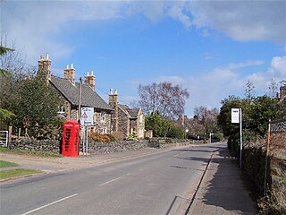
Cropston is a village within the civil parish of Thurcaston & Cropston, part of the Borough of Charnwood in Leicestershire, England. It is on the edge of Charnwood Forest, and lies close to Bradgate Park.

Newtown Linford is a linear village in Leicestershire, England. The population of the civil parish was 1,000 at the 2001 census, including Ulverscroft and increasing to 1,103 at the 2011 census.
Swithland is a linear village in the Charnwood borough of Leicestershire, England. The civil parish population was put at 230 in 2004 and 217 in the 2011 census. It is in the old Charnwood Forest, between Cropston, Woodhouse and Woodhouse Eaves. It has a village hall, a parish church and a public house, the Griffin Inn. The village is known for the slate that was quarried in the area.

Woodhouse Eaves is a village located on the side of Beacon Hill, in the Charnwood Forest area of Leicestershire, England. It has a mixture of small and large modern houses, although it is more dense in old houses, making it one of the most expensive villages in the county. At the 2011 census the population of around 1,300 was included in the civil parish of Woodhouse.

Swithland Wood and The Brand is a 87.9 hectares biological Site of Special Scientific Interest south of Woodhouse Eaves in Leicestershire. Swithland Wood is a Nature Conservation Review site, Grade II. The Brand is designated a Precambrian site in the Geological Conservation Review site, but the dating has been changed due to the discovery of trace fossils from the succeeding Cambrian period.
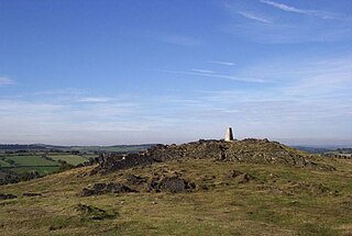
Old John is the highest hill in Bradgate Park, Leicestershire, England, on the southern edge of Charnwood Forest. It gives its name to the folly that stands at its top. The hill stands at 212 metres (696 ft) high, and is a prominent landmark across Leicester and Leicestershire.
Bradgate Electoral Division is a County Council electoral division in Leicestershire, England, taking its name from Bradgate Park which is at the centre of the division. It includes the villages of Anstey, Cropston, Thurcaston, Newtown Linford, Ulverscroft, Swithland, Woodhouse and Woodhouse Eaves, and is currently represented by Deborah Taylor.
George Harry Booth-Grey, 7th Earl of Stamford and 3rd Earl of Warrington was an English cricketer, landowner and peer, who sat on the Whig benches in the House of Lords.
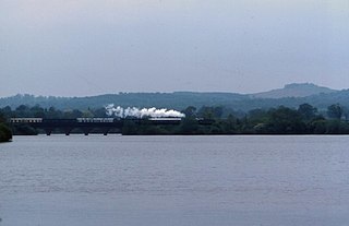
Swithland Reservoir is a reservoir in the English county of Leicestershire. It is north-east of the village of Swithland from which it takes its name, north-west of Rothley and approximately 133 metres (145 yd) south-west of Mountsorrel Quarry. It is part of the 187.1-hectare (462-acre) Buddon Wood and Swithland Reservoir Site of Special Scientific Interest (SSSI).

Beacon Brook is a brook which runs through North Leicestershire. The source of the rivulet is in Beacon, near Woodhouse Eaves. The water way runs through Beaumanor Hall before there is a convergence with the River Lin in Quorn. The river runs for around 6 kilometres between its source and confluence with the River Lin.

