Ulverscroft

Last updated

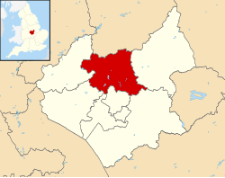
Ulverscroft is a civil parish in the Charnwood district of Leicestershire. It has a population of about 100. The population in 2011 is included in the civil parish of Newtown Linford. There is no village by the name, but there was previously an Ulverscroft Priory. [1]

Ruins of the Augustinian priory in Ulverscroft Ulverscroft Priory - geograph.org.uk - 172533.jpg
Ruins of the Augustinian priory in Ulverscroft

There are some good examples of early Arts and Crafts movement architecture in and around Ulverscroft including Stoneywell by Ernest Gimson. Stoneywell, now a National Trust property, opened to the public in 2015. [2]
Notes

  1. ClickIt! Living Photography
  2. "Leicestershire's Stoneywell cottage opened to the public". bbc.co.uk. BBC. 1 February 2015. Retrieved 27 July 2022.

Commons-logo.svg Media related to Ulverscroft at Wikimedia Commons

Coordinates: 52°42′14″N1°16′01″W / 52.704°N 1.267°W / 52.704; -1.267


Related Research Articles

Copt Oak

Copt Oak is a place in Leicestershire in England. It is in the North West Leicestershire district, near Bawdon Lodge, Charley and Ulverscroft.

Stoughton, Leicestershire

Stoughton is a village and civil parish in the Harborough district of Leicestershire. The population at the 2011 census was 351.

Wymeswold Village in Leicestershire, England

Wymeswold is a village and civil parish in the Charnwood district of Leicestershire, England. It is in the north of Leicestershire, and north-east of Loughborough. The village has a population of about 1,000, measured at 1,296 in the 2011 census. It is close to Prestwold and Burton on the Wolds in Leicestershire, and the Nottinghamshire villages of Rempstone and Willoughby on the Wolds.

Prestwold Human settlement in England

Prestwold is a hamlet and civil parish in the Charnwood district of Leicestershire, England. The parish has a population of around 60. The population at the 2011 census remained less than 100 and is included in the civil parish of Hoton. Nearby places are Hoton, just to the north, and Burton on the Wolds, to the south-east.

Seagrave Human settlement in England

Seagrave is a village and civil parish in the Charnwood district of Leicestershire, England. It has a population of around 500, measured at the 2011 census as 546, It is north of Sileby and close to Thrussington and Barrow upon Soar.

Great Easton, Leicestershire Human settlement in England

Great Easton is a village and civil parish in the Harborough district of Leicestershire, England. The parish had a population of 558 according to the 2001 census, increasing to 671 at the 2011 census.

Claybrooke Parva

Claybrooke Parva is a village and civil parish in the Harborough district south west Leicestershire, England close to Claybrooke Magna. The village is the site of a church which is thought to originally be part Anglo Saxon with Norman and Medieval additions. The population of the civil parish at the 2011 census was 208.

Swinford, Leicestershire

Swinford is a nucleated village and civil parish in the Harborough district of the English county of Leicestershire. The population of the civil parish at the 2011 census was 586. It used to be on the former A427, which led under the M1, to Catthorpe. The parish church is All Saints, a 12th-century Norman rebuilding of an earlier Saxon church with a 14th-century square bell tower and a Grade II* listed building. The local pub is The Chequers on the High Street, formerly known as Chequer Inn.

Swannington, Leicestershire Human settlement in England

Swannington is a former mining village situated between Coalville and Ashby-de-la-Zouch, Leicestershire, England. A document of 1520 mentions five pits at Swannington. It was a terminus of the early (1832) Leicester and Swannington Railway that was built to carry away its pits' output.

Hemington, Leicestershire Human settlement in England

Hemington is a village in Leicestershire, England.

Chilcote Human settlement in England

Chilcote is a village and civil parish in the North West Leicestershire district of Leicestershire, England. Until 1897 it was in Derbyshire. The parish had a population of 108 according to the 2001 census, including Stretton-en-le-Field and increasing to 200 at the 2011 census.

Lockington-Hemington

Lockington-Hemington is a civil parish in the North West Leicestershire district of Leicestershire, England. The parish includes the villages of Hemington and Lockington. According to the 2001 census it had a population of 556, rising to 838 at the 2011 census.

Isley cum Langley

Isley cum Langley is a civil parish in the North West Leicestershire district of Leicestershire, England. According to the 2001 census it had a population of 64. At the 2011 census the population of the civil parish remained less than 100 and is included in the civil parish of Breedon on the Hill.

Noseley

Noseley is a village and civil parish in the Harborough district of Leicestershire, England.

Peggs Green is a hamlet within the parish of Coleorton, Leicestershire. For many years it had formed part of the civil parish of Thringstone, until this was dissolved in 1936.

Stoneywell Historic house, gardens and woodland near Coalville, Leicestershire, England

Stoneywell is a National Trust property in Ulverscroft, a dispersed settlement near Coalville in Charnwood Forest, Leicestershire. Stoneywell is the largest of a small group of cottages designed in the Arts and Crafts style by Ernest Gimson. It was built in collaboration with Detmar Blow in 1899 for Ernest's brother Sydney Gimson as a summer residence, and along with much original furniture, it remained in the Gimson family for over a century. As part of a highly influential vernacular movement, it has become well known within Arts and Crafts circles. In spring 2013 the National Trust announced that following a year-long appeal, it had been able to acquire the house with its Arts and Crafts contents, gardens and woodland. It was opened to the public in February 2015.

Luston Human settlement in England

Luston is a village and civil parish in north Herefordshire. It is 3 miles (5 km) north from Leominster on the B4361 road. To the south from the village of Luston is the hamlet of The Broad. The population of the civil parish at the 2011 census was 541.

Ulverscroft Valley

Ulverscroft Valley is a 110.8 hectares biological Site of Special Scientific Interest north-west of Markfield in Leicestershire. The site is in five separate blocks, and two areas are nature reserves managed by the Leicestershire and Rutland Wildlife Trust (LRWT). Lea Meadows is owned by the LRWT and it is also a scheduled monument. Part of Ulverscroft Nature Reserve is owned by the LRWT and part is owned by the National Trust and leased to the LRWT.

Lea Meadows

Lea Meadows is a 12-hectare (30-acre) nature reserve east of Markfield in Leicestershire. It is owned and managed by the Leicestershire and Rutland Wildlife Trust. It is part of the Ulverscroft Valley, which is a Site of Special Scientific Interest, and part of it is a scheduled monument.

Ulverscroft Nature Reserve Nature reserve near Markfield, Leicestershire, England

Ulverscroft is a 56-hectare (140-acre) nature reserve north of Markfield in Leicestershire, England. It is managed by the Leicestershire and Rutland Wildlife Trust (LRWT) and part of it is owned by the National Trust and part by the LRWT. The site is partly in Ulverscroft Valley, which is a Site of Special Scientific Interest.