Birstall, Leicestershire

Last updated

Birstall
Birstallvillagesign.jpg
The village sign depicts a Cedar tree [1]
Leicestershire UK location map.svg
Red pog.svg
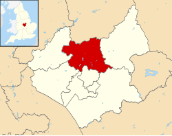
Birstall
Location within Leicestershire
Population12,216 (2011)
OS grid reference SK596088
Civil parish
  • Birstall
District
Shire county
Region
Country England
Sovereign state United Kingdom
Post town LEICESTER
Postcode district LE4
Dialling code 0116
Police Leicestershire
Fire Leicestershire
Ambulance East Midlands
UK Parliament
List of places
UK
England
Leicestershire
52°40′25″N1°07′12″W / 52.67364°N 1.12000°W / 52.67364; -1.12000

Birstall is a large village and civil parish within the Charnwood borough of Leicestershire, England. It is three miles north of Leicester city centre and is part of the wider Leicester Urban Area.

Contents

It is the largest village in Charnwood, with a population only marginally lower than the neighbouring town of Syston at the 2001 census.

The village

Birstall lies on the A6 and is the last major settlement before Leicester when arriving from the north. Birstall thus forms part of the Leicester Urban Area. The village centre lies just off the A6, along Sibson Road. The village contains two supermarkets, a garden centre and a variety of other shops. There are a number of schools, including Highcliffe Primary School, Riverside Primary School, Hallam Fields Primary School and The Cedars Academy. The village contains the Church of St James the Great, Birstall, [2] the St Teresa Roman Catholic church and Birstall Methodist Church.

There is a large housing estate in the north-west of the village, leading off Greengate Lane.

The Grand Union Canal runs along the eastern side of the village, which is adjacent to Watermead Country Park, a series of lakes in the bottom of the Soar Valley, which have been set aside as a recreational area and country park.

Birstall village centre. "The Triangle" - geograph.org.uk - 581952.jpg
Birstall village centre.

The Great Central Railway steam railway has its southern terminus near the village, where the A6 meets the Leicester outer ringroad at Red Hill Circle. Just north of Red Hill Circle, and west of the A6, is Red Hill filling station, which became a Grade II listed building in 2012. The railway also forms the boundary of the southern end of Birstall Golf Club.

To the north of the village, the A6 meets the A46 Leicester Western Bypass and then continues on towards Loughborough along the Soar Valley.

The symbol of Birstall is a Cedar tree. [1] The original tree stands in Roman Road. It was once in the grounds of the now demolished Birstall Hall.

The local Royal Air Force Air Cadet squadron is 1947(Birstall) Squadron.

The area of the Parish is 791 acres (3.20 km2).

History

Church of St James the Great, Birstall on Church Hill. Here lies the grave of John Hannah (VC). Birstall Church.jpg
Church of St James the Great, Birstall on Church Hill. Here lies the grave of John Hannah (VC).

The village's name means 'settlement built on the site of a fortification'. [3]

Saxon remnants have been found in the village and surrounding area. The village was called Burstalle in the Domesday Book when it belonged to Hugh de Grandmesnil. [4] Willard held these lands for Hugh and the 16 acres (65,000 m2) of meadow and a mill were said to be worth three ounces of gold. The village was a small one until the arrival of the Great Central Railway in 1899. From then onwards development has continued and still continues to-day. Between 1901 and the 2001 the population grew from 611 to over 11,000.

Hallam Fields

A new housing development called 'Hallam Fields' commenced construction in 2006 and was well advanced by 2008. It occupies land to the west of the A6, between the 'Gates' estate and the A46. The development will take ten years to complete, consisting of up to 900 properties including schools, shops, offices, industrial units and a fire station. It has been described as a mini Poundbury. By April 2010 it had 11 streets. These are Archdale Close, Bridge Green, Dale Close, Far Pastures Road, Halfpenny Close, Hallam Fields Road, Little Connery Lees, Pinfold Close, Brook Furlong Drive, Palmer Square and Lady Augusta Road. North of the development, on the roundabout connecting the A46 and A6 is a new service area with a KFC, a Shell petrol station and an Ibis Budget.

Places and buildings within the village

Schools:

Note: Longslade Community College and Stonehill high school merged to become Cedars Academy

Shops:

Community facilities:

Parks:

Golf club:

Pubs / Clubs:

Local organisations:

Transport

The main village areas of Wanlip Lane and Harrowgate Drive are served by Centrebus service 22A while the A6 corridor is served by buses between Leicester and Loughborough operated by Kinchbus service 2 (until 4 September 2022), Skylink and Arriva Midlands services 126 and 127.

The Birstall Park and Ride service is at the northern end of the village and is operated by Roberts Travel Group.

Neighbouring villages

The closest village to Birstall is Wanlip, a smaller village, with the village of Rothley being the next closest. The villages of Thurmaston and Syston are also nearby as well as Thurcaston. Birstall shares its southern border with the City of Leicester.

Twin towns

Related Research Articles

<span class="mw-page-title-main">Borough of Charnwood</span> Borough and non-metropolitan district in England

Charnwood is a local government district with borough status in the north of Leicestershire, England. It is named after Charnwood Forest, much of which lies within the borough. The council is based in Loughborough, the area's largest town. The borough also contains the towns of Shepshed and Syston, along with numerous villages and surrounding rural areas. In the south of the borough it includes parts of the Leicester Urban Area, notably at Birstall and Thurmaston.

<span class="mw-page-title-main">Glenfield, Leicestershire</span> Human settlement in England

Glenfield is a large village and former civil parish, now in the parish of Glenfields, in the Blaby district of Leicestershire, England. At the 2011 Census, Glenfields had a population of 9,643.

<span class="mw-page-title-main">Belgrave, Leicester</span> Suburb of Leicester, England

Belgrave is an area, suburb, electoral ward and administrative division of the city of Leicester, in the ceremonial county of Leicestershire, England. Belgrave is the location of and known for the National Space Centre, Space Park Leicester, the Golden Mile and Belgrave Hall.

<span class="mw-page-title-main">Thurmaston</span> Village in Leicestershire, England

Thurmaston is a village and civil parish in Leicestershire, England, located within the Borough of Charnwood. At the 2011 census, it had a population of 9,668.

<span class="mw-page-title-main">Anstey, Leicestershire</span> Human settlement in England

Anstey is a large village in Leicestershire, England, located north west of Leicester in the borough of Charnwood. Its population was 6,528 at the 2011 census. This figure is expected to increase due to the building of a new housing development off Groby Road. The village is separated from Leicester by the Rothley Brook, Castle Hill Park and the A46, and it borders the villages of Glenfield, Groby, Newtown Linford, Cropston and Thurcaston as well as the suburb of Beaumont Leys and Anstey Heights. To the north-west lies Bradgate Park.

<span class="mw-page-title-main">Mountsorrel</span> Human settlement in England

Mountsorrel is a village in Leicestershire on the River Soar, just south of Loughborough with a population in 2001 of 6,662 inhabitants, increasing to 8,223 at the 2011 census.

<span class="mw-page-title-main">Thurcaston</span> Human settlement in England

Thurcaston is a village and former civil parish, now in the parish of Thurcaston and Cropston, in the Charnwood district, in Leicestershire, England. It was the home of Bishop Hugh Latimer.

<span class="mw-page-title-main">Queniborough</span> Village in Leicestershire, England

Queniborough is an English village in the county of Leicestershire 2.5 miles (4 km) north-east of the town of Syston and of 7.5 miles (12 km) north-east of the city of Leicester. Its 972 properties housed 1,878 registered electors in 2003. The population increased to 2,326 at the 2011 census. It forms part of the Leicester Urban Area due to its proximity. The parish church of St Mary's has, according to the architectural historian Nikolaus Pevsner, "one of the finest spires in the whole of Leicestershire".

<span class="mw-page-title-main">Syston</span> Town in Charnwood, Leicestershire, England

Syston is a town and civil parish in the district of Charnwood in Leicestershire, England. The population was 11,508 at the 2001 census, rising to 12,804 at the 2011 census.

<span class="mw-page-title-main">Charnwood (UK Parliament constituency)</span> UK Parliament constituency since 1997

Charnwood is a constituency in Leicestershire represented in the House of Commons of the UK Parliament since 2015 by Edward Argar, a Conservative.

<span class="mw-page-title-main">Sileby</span> Human settlement in England

Sileby is a former industrial village and civil parish in the Soar Valley in the Charnwood borough of Leicestershire, England. It is located between Leicester and Loughborough. The village is close to Barrow upon Soar, Mountsorrel, Ratcliffe-on-the-Wreake, Seagrave and Cossington. The population of the civil parish at the 2011 census was 7,835, rising to 8,959 at the 2021 census.

<span class="mw-page-title-main">Wanlip</span> Human settlement in England

Wanlip is a small village and civil parish in the Charnwood district of Leicestershire, with a population measured at 305 at the 2011 census. It is a countryside village, north of Birstall, and west of Watermead Country Park and the River Soar. The A46 road runs directly past the village. Wanlip won the 2008 Leicester and Rutland Best Village Competition for villages with a population under 500.

<span class="mw-page-title-main">Watermead Country Park</span>

The Watermead Country Park is a network of artificial lakes in the valley of the River Soar and the old Grand Union Canal, in and to the north of Leicester and in and to the south of the Borough of Charnwood in Leicestershire. The southern part of the park, which includes the Hill and the Mammoth is located in Rushey Mead. It runs north to south along the path of the watercourses, with Birstall to the west and Thurmaston to the east. The parks provide bird watching, fishing and watersports facilities, and are managed by a partnership of Leicestershire County Council, Leicester City Council and Charnwood Borough Council.

<span class="mw-page-title-main">Rushey Mead</span> Suburb of Leicester, England

Rushey Mead is an area, suburb, electoral ward and administrative division of the city of Leicester, England. The population of the ward at the 2011 census was 15,962. It comprises the northern Leicester suburb of Rushey Mead in its entirety, as well as a part of the neighbouring area, suburb and electoral ward of Belgrave and historical parts of neighbouring Northfields and Thurmaston.

<span class="mw-page-title-main">East Goscote</span> Human settlement in England

East Goscote is a modern village and civil parish in the Borough of Charnwood district of Leicestershire, England, just north of the market town of Syston. It is a medium-sized village, with a population measured at 2,866 in the 2011 census. The village is twinned with Fleury-sur-Andelle, France.

<span class="mw-page-title-main">The Cedars Academy</span> Academy in Birstall, Leicestershire, England

The Cedars Academy is a co-educational secondary school and sixth form located in Birstall in the English county of Leicestershire.

<span class="mw-page-title-main">A607 road</span> Road in England

The A607 is an A road in England that starts in Belgrave, Leicester and heads northeastwards through Leicestershire and the town of Grantham, Lincolnshire, terminating at Bracebridge Heath, a village on the outskirts of Lincoln. It is a primary route from Thurmaston to the A1 junction at Grantham.

Mid Leicestershire is a proposed constituency of the House of Commons in the UK Parliament. Further to the completion of the 2023 Periodic Review of Westminster constituencies, enacted by the Parliamentary Constituencies Order 2023, it will first be contested at the next general election.

References

  1. 1 2 Birstall Parish Council Archived 12 August 2011 at the Wayback Machine , accessed 26 July 2008
  2. [St James' Church], accessed 25 July 2008
  3. "Key to English Place-names". kepn.nottingham.ac.uk. Archived from the original on 11 August 2021. Retrieved 14 August 2021.
  4. Domesday Book: A Complete Translation. London: Penguin, 2003. p. 655 ISBN   0-14-143994-7
  5. Birstall Golf Club Archived 30 May 2008 at the Wayback Machine , accessed 25 July 2008
  6. "1947(Birstall) Squadron – C/O Riverside Academy, Wanlip Lane, Birstall, Leicester. LE4 4JU. Tel: 0116 267 5631" . Retrieved 19 January 2024.