This article needs additional citations for verification .(August 2019) |
East Goscote | |
---|---|
![]() | |
Location within Leicestershire | |
Population | 2,866 |
District | |
Shire county | |
Region | |
Country | England |
Sovereign state | United Kingdom |
Post town | LEICESTER |
Postcode district | LE7 |
Police | Leicestershire |
Fire | Leicestershire |
Ambulance | East Midlands |
UK Parliament | |
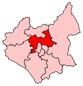
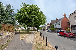
52°42′52″N1°03′15″W / 52.71448°N 1.05404°W East Goscote is a modern village and civil parish in the Borough of Charnwood district of Leicestershire, England, just north of the market town of Syston. It is a medium-sized village, with a population measured at 2,866 in the 2011 census. [1] The village is twinned with Fleury-sur-Andelle, France.
The village's name either derives from the Old English gos-cot meaning 'cottages where geese are kept', or from an Anglo-Saxon named Gosa. [2]
The name is taken from the East Goscote Hundred, one of the old hundreds (an area of land purported to be able to support 100 families) of Leicestershire. The Goscote Hundred (or Wapentake) is mentioned in the Domesday Book, this was later split into the West and East Goscote Hundreds.
It was the first new village to be created in Leicestershire since Domesday.
The village is built on the site of a former British Army supply depot. According to Ministry of Defence (MoD) files, the site was originally constructed in 1940 (finished September 1942) by Holloway Brothers, and was an Agency Filling Factory run by Lever Brothers/Unilever as No.10 Royal Ordnance Factory (10 ROF). At that time, it was known as the Queniborough Depot, since that was the closest village to it. It began production in March/April 1942. The aerial photograph reveals its former road layout. According to English Heritage's reference work Dangerous Energy, it was operating Groups 8-10 of ROF filling types (High Explosives received, mixed, and put into bombs and warheads). By 1944, it was temporarily occupied by the War Office. A report of 1951 has it designated as 78 COSD (Command Ordnance Sub Depot). It was decommissioned in 1959, and subsequently bought for housing development by Jelson Homes. This development began in 1962. There were two enormous shell storage bunkers that could not be demolished, and these were earthed over and landscaped. They became known locally as the 'Mound', and are now part of the adjacent playing fields. These were opened to the public as part of the Queen's Silver Jubilee celebrations in 1977, and there is a plaque near Long Furrow noting this fact.
The road called Long Furrow serves as a perimeter around the central part of the village; it also serves to mark the boundary of the former ordnance site. What is less well known is the huge network of large reinforced concrete tunnels that lay beneath the whole village; where the munitions were fitted with their warheads, and new top secret weapons prototypes were put together. There are several entrances to these workshops and tunnels located throughout the village, but each have been carefully landscaped to conceal their identity. Council representatives did enter these chambers,[ when? ] and found that the tunnels were in excellent condition, and the electricity still worked. Until the mid-1970s, during which the village was still under construction, both entrances to the 'Mound' were open, and often visited by local children.
A map of the actual tunnel layout did exist in the Library of Wreake Valley Community College, Syston, but was misplaced to keep the tunnels hidden. The whole structure, and stories that lay beneath its present inhabitants is worthy of a serious study, survey, and television documentary.
The first family to move in did so in 1965, even though the village lacked many amenities at the time, including street lighting.
The village is served by Broomfield County Primary School, which was opened in 1968. The school was expanded in 1977 to cope with the number of children on the village.
The original design made no mention of the village hall, and this was built by Jelson Homes free of charge. It was the home of religious services until the completion of St Hilda's Church in 1976. The first village vicar was the Reverend Dudley Gummer, who took services in his own house in Coopers Nook, until the village hall was built.
The village had its own magazine East Goscote Community News, which was first published in 1969. It ceased publication in the mid-1980s, after many issues. Now they have a magazine called Long Furrow.
Adjacent to the village, north of the railway line, is Beedles Lake Golf Club.
East Goscote ward is represented on Charnwood Borough Council by Green Party Councillor Laurie Needham. [3] Before 2015, it was represented by Cathy Duffy, the only elected representative in the locality from the far-right British National Party (BNP). [4]
Charnwood Borough Council has stated that there will be a new railway station to open at East Goscote, on the railway line towards Melton Mowbray. [5]
Leicestershire is a ceremonial county in the East Midlands of England. It is bordered by Derbyshire, Nottinghamshire, and Lincolnshire to the north, Rutland to the east, Northamptonshire to the south-east, Warwickshire to the south-west, and Staffordshire to the west. The city of Leicester is the largest settlement and the county town.
Charnwood is a local government district with borough status in the north of Leicestershire, England. It is named after Charnwood Forest, much of which lies within the borough. The council is based in Loughborough, the area's largest town. The borough also contains the towns of Shepshed and Syston, along with numerous villages and surrounding rural areas. In the south of the borough it includes parts of the Leicester Urban Area, notably at Birstall and Thurmaston.
Wycomb is a small hamlet in the district of Melton, which is approximately 4 miles (6.4 km) northeast of Melton Mowbray in Leicestershire, and is part of the civil parish of Scalford, which also includes the neighbouring village of Chadwell. Until 1 April 1936 it was in the parish of Wycomb and Chadwell.
Cossington is a village within the Soar Valley in Leicestershire, England. It lies between Sileby, Rothley, Ratcliffe-on-the-Wreake and Syston. The population of the civil parish at the 2011 census was 598.
Burton on the Wolds is a village in Leicestershire, England situated on the B676 road 3 miles (4.8 km) west of the A46 and about the same distance to the east of Loughborough, close to the county border with Nottinghamshire. In the 2011 census, the population was measured at 1,218. The Parish Council of Burton on the Wolds, Cotes and Prestwold serves the village and its two neighbouring hamlets. The local borough council is Charnwood.
Thurmaston is a village and civil parish in Leicestershire, England, located within the Borough of Charnwood. At the 2011 census, it had a population of 9,668.
This article is intended to give an overview of the history of Leicestershire.
Rutland and Melton is a county constituency spanning Leicestershire and Rutland, represented in the House of Commons of the Parliament of the United Kingdom since 2019 by Alicia Kearns, a Conservative. It elects one Member of Parliament (MP) by the first-past-the-post system of election.
Birstall is a large village and civil parish within the Charnwood borough of Leicestershire, England. It is three miles north of Leicester city centre and is part of the wider Leicester Urban Area.
Syston is a town and civil parish in the district of Charnwood in Leicestershire, England. The population was 11,508 at the 2001 census, rising to 12,804 at the 2011 census.
Charnwood is a constituency in Leicestershire represented in the House of Commons of the UK Parliament since 2015 by Edward Argar, a Conservative.
Barrow upon Soar is a large village in northern Leicestershire, in the Soar Valley between Leicester and Loughborough, with a population at the 2011 census of 5,856.
Markfield is a large village in both the National Forest and Charnwood Forest and in the Hinckley and Bosworth district of Leicestershire, England. The settlement dates back to at least the time of the Norman conquest and is mentioned in the Domesday Book under the name Merchenefeld. A variant of this is still used as the name for the village primary school, Mercenfeld. It is to the south-east of Junction 22 of the M1, and to the south of the A50. The highest point in Markfield is shown on OS sheet 129 at 222 metres above sea level. Nearby places are Newtown Linford, Groby, Field Head, and Stanton under Bardon. In the 1841 census its population was recorded at 1,203. In the 2011 census the parish had a population of 5681. Markfield is within the LE67 postcode district. In 2012 Hinckley & Bosworth Borough Council published an overview of Markfield conservation area.
Ratcliffe on the Wreake is a village and civil parish in the Charnwood district of Leicestershire, England. The population of the civil parish at the 2011 census was 179. It is just to the north of the River Wreake, opposite East Goscote.
Seagrave is a village and civil parish in the Charnwood district of Leicestershire, England. It has a population of around 500, measured at the 2011 census as 546, It is north of Sileby and close to Thrussington and Barrow upon Soar.
Chadwell is a small village in the district of Melton, which is approximately 4 miles (6.4 km) northeast of Melton Mowbray in Leicestershire, and is part of the civil parish of Scalford, which also includes the neighbouring hamlet of Wycomb. Until 1 April 1936 it was in the parish of Wycomb and Chadwell. The village name means 'spring/stream which is cold'. Chadwell is half a mile east of Wycomb, and they share the Church of St. Mary in the same ecclesiastical parish. The Church of St Mary is a Grade II* listed building.
St Mary's Church, Barkby is the Church of England Parish Church for Barkby, Leicestershire, England. The church mostly dates from the 13th century. It was Grade I listed in 1966.
Elections to the Charnwood Borough Council took place on 5 May 2011, in line with other local elections in the United Kingdom. A total of 52 councillors were elected from 28 wards as the whole council was up for election.
Melton and Syston is a proposed constituency of the House of Commons in the UK Parliament. Further to the completion of the 2023 Periodic Review of Westminster constituencies, enacted by the Parliamentary Constituencies Order 2023, it will first be contested at the next general election.
The County Council intends to provide additional stations at Thurmaston and East Goscote when resources permit to extend the suburban rail service.