Thurcaston

Last updated

Thurcaston
Thurcaston All saints Church.jpg
All Saints' Church, Thurcaston
Leicestershire UK location map.svg
Red pog.svg
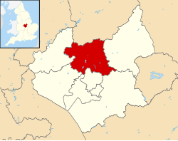
Thurcaston
Location within Leicestershire
Population800 (estimated 2001)
District
Shire county
Region
Country England
Sovereign state United Kingdom
Post town LEICESTER
Postcode district LE7
Dialling code 0116
Police Leicestershire
Fire Leicestershire
Ambulance East Midlands
UK Parliament
List of places
UK
England
Leicestershire
52°40′59″N1°09′00″W / 52.683°N 1.15°W / 52.683; -1.15 Coordinates: 52°40′59″N1°09′00″W / 52.683°N 1.15°W / 52.683; -1.15

Thurcaston is a village and former civil parish, now in the parish of Thurcaston and Cropston, in the Charnwood district, in Leicestershire, England. It was the home of Bishop Hugh Latimer.

Contents

It borders the villages of Anstey and Cropston, as well as the Leicester suburb of Beaumont Leys. The Rothley Brook flows through the village. The A46 Leicester Western Bypass runs close to the village, separating it from Leicester, Birstall, and Beaumont Leys.

The village of Thurcaston has existed since at least the 8th century AD, and includes a church and several old houses, along with a very small Methodist Chapel. In general, there are few commercial properties, but there exists a pub, The Wheatsheaf Inn, and an electrical showroom, Tebbatts Electronics. There is a single bus service, the 154 run by Centrebus at a maximum frequency of every hour. The previous service, the 55, was shut down in the late 2000s.

Large fields between the Great Central Railway line and the houses of the residents of Leicester Road form a popular place for walking dogs and horses.

A planned housing development is currently being discussed with Charnwood Borough council, upon which will see the erection of up to 50 dwellings, community centre and park, including sustainable drainage system with access off Mill Road, the large area of land is to the east off Mill Road. [1]

Civil parish

On 1 April 1935 the parish of Cropston was merged with Thurcaston, parts of Beaumont Leys was also merged, [2] on 7 August 1989 the parish was renamed "Thurcaston & Cropston". [3] In 1931 the parish of Thurcaston (prior to the merge) had a population of 336. [4]

Richard Hill Primary School

The village school is Richard Hill Primary School, which was founded in 1715 by Richard Hill, a resident of the village. Originally Richard Hill Primary School was located further up Anstey Lane but after expansion into the Memorial Hall in the early 1960s, it was moved further towards Leicester Road in 1968, after accepting more students from Cropston and All Saints/Hall Farm Road. It was further extended by the addition of two classrooms in 1970.[ citation needed ]

In recent[ when? ] years Richard Hill has had varied results in League Tables. [5] [ needs update ]

Thurcaston children go to The Martin High School in the neighbouring village of Anstey from the age of 11 to 16, and The Cedars Academy and Rawlins Academy for 11–18.

Related Research Articles

<span class="mw-page-title-main">Borough of Charnwood</span> Borough in England

The Borough of Charnwood is a local government district with borough status in the north of Leicestershire, England, which has a population of 166,100 as of the 2011 census. It borders Melton to the east, Harborough to the south east, Leicester and Blaby to the south, Hinckley and Bosworth to the south west, North West Leicestershire to the west and Rushcliffe in Nottinghamshire to the north. It is named after Charnwood Forest, an area which the borough contains much of.

<span class="mw-page-title-main">Glenfield, Leicestershire</span> Human settlement in England

Glenfield is a large village and former civil parish, now in the parish of Glenfields, in the Blaby district of Leicestershire, England. At the 2011 Census, Glenfields had a population of 9,643. Its located at the northwestern fringe of the city of Leicester.

<span class="mw-page-title-main">Shepshed</span> Town in Leicestershire, England

Shepshed is a town in Leicestershire, England with a population of 13,505 at the 2011 census. It is part of the borough of Charnwood local authority, where Shepshed is the second biggest settlement after the town of Loughborough.

<span class="mw-page-title-main">Anstey, Leicestershire</span> Human settlement in England

Anstey is a large village in Leicestershire, England, located north west of Leicester in the borough of Charnwood. Its population was 6,528 at the 2011 census. This figure is expected to increase due to the building of a new housing development off Groby Road. The village is separated from Leicester by the Rothley Brook, Castle Hill Park and the A46, and it borders the villages of Glenfield, Groby, Newtown Linford, Cropston and Thurcaston as well as the suburb of Beaumont Leys and Anstey Heights. To the north-west lies Bradgate Park.

<span class="mw-page-title-main">Cropston</span> Human settlement in England

Cropston is a village and former civil parish, now in the parish of Thurcaston and Cropston, part of the Borough of Charnwood in Leicestershire, England. It is on the edge of Charnwood Forest, and lies close to Bradgate Park. In 1931 the parish had a population of 404.

<span class="mw-page-title-main">Birstall, Leicestershire</span> Human settlement in England

Birstall is a large village and civil parish within the Charnwood borough of Leicestershire, England. It is three miles north of Leicester city centre and is part of the wider Leicester Urban Area.

<span class="mw-page-title-main">Newtown Linford</span> Human settlement in England

Newtown Linford is a linear village in Leicestershire, England. The population of the civil parish was 1,000 at the 2001 census, including Ulverscroft, increasing to 1,103 at the 2011 census.

<span class="mw-page-title-main">Charnwood (UK Parliament constituency)</span> UK Parliament constituency since 1997

Charnwood is a constituency in Leicestershire represented in the House of Commons of the UK Parliament since 2015 by Edward Argar, a Conservative.

<span class="mw-page-title-main">Beaumont Leys</span> Suburb and electoral ward in north-western Leicester, England

Beaumont Leys is a suburb and electoral ward in north-western Leicester, England. The population of the ward at the 2011 census was 16,480. Locally, Beaumont Leys is usually used in reference to the large housing estate, built within the administrative division, centred on Strasbourg Drive.

<span class="mw-page-title-main">Barkby</span> Human settlement in England

Barkby is a village and civil parish in the Charnwood district of Leicestershire, England. It is situated north-east of Leicester, and only a short way from Leicester's urban sprawl in Thurmaston and Syston. Nearby villages are Beeby and Barkby Thorpe. Barkby Brook is the main watercourse which flows through Barkby. The parish has a population of around 300.

Thurcaston and Cropston is a civil parish in Leicestershire, England. As its name suggests, it consists of the villages of Thurcaston and Cropston. The parish had a population at the 2001 Census of 2,076, with around 1,200 in Cropston and 800 in Thurcaston. The population of the civil parish was 2,074 at the 2011 census. The villages are separated by the Rothley Brook.

<span class="mw-page-title-main">Croxton Kerrial</span> Village in Melton borough, Leicestershire, England

Croxton Kerrial is a village and civil parish in the Melton borough of Leicestershire, England, 6.6 miles (10.6 km) south-west of Grantham, 7.9 miles (12.7 km) north-east of Melton Mowbray, and 0.5 miles (0.8 km) west of Leicestershire's border with Lincolnshire. The civil parish includes the village of Branston and had a population of 530 at the 2011 census.

<span class="mw-page-title-main">Long Whatton</span> Human settlement in England

Long Whatton is a village and former civil parish, now in the parish of Long Whatton and Diseworth, in the North West Leicestershire district, in the English county of Leicestershire. It is south of East Midlands Airport, off Junctions 23 and 23A of the M1 motorway, and has easy access to Loughborough via the A6 and to Shepshed, Ashby-de-la-Zouch and Kegworth.

<span class="mw-page-title-main">Swithland Reservoir</span> Body of water

Swithland Reservoir is a reservoir in the English county of Leicestershire. It is north-east of the village of Swithland from which it takes its name, north-west of Rothley and approximately 133 metres (145 yd) south-west of Mountsorrel Quarry. It is part of the 187.1-hectare (462-acre) Buddon Wood and Swithland Reservoir Site of Special Scientific Interest (SSSI).

The Martin High School is a coeducational secondary school with academy status, located in the village of Anstey, Leicestershire, on the outskirts of Leicester. The school accepts students from nearby Beaumont Leys, Glenfield, Thurcaston and Cropston as well as some students from New Parks and Braunstone.

<span class="mw-page-title-main">Nether Broughton</span> Human settlement in England

Nether Broughton is a village and former civil parish, now in the parish of Broughton and Old Dalby, in the Melton district, in Leicestershire, England. Broughton and Old Dalby's parish council is based in Nether Broughton. The village lies on the main A606 road between Melton Mowbray and Nottingham. The neighbouring village of Upper Broughton is on the same road, but within Nottinghamshire county. In 1931 the parish had a population of 345. On 1 April 1936 the parish was abolished to form "Broughton and Old Dalby".

<span class="mw-page-title-main">St Mary's Church, Anstey</span> Church in United Kingdom

St Mary's Church is the Church of England parish church in Anstey, Leicestershire, in the Diocese of Leicester.

<span class="mw-page-title-main">River Lin</span> River in Leicestershire, England

The River Lin is a river which runs through North Leicestershire. The source of the river is in Ulverscroft, near Charnwood Forest. The river runs through Bradgate Park before the river runs into the River Soar in Quorn. The river also feeds Cropston Reservoir and Swithland Reservoir. The river runs for around 17 kilometres between its source and confluence with the River Soar. The river is described as one of Leicestershire's shortest rivers.

References

  1. "Leicestershire Villages - Thurcaston - Planning Applications". www.leicestershirevillages.com. Archived from the original on 21 August 2008.
  2. "Relationships and changes Thurcaston CP/AP through time". A Vision of Britain through Time. Retrieved 31 December 2022.
  3. "Loughborough Registration District". UKBMD. Retrieved 31 December 2022.
  4. "Population statistics Thurcaston CP/AP through time". A Vision of Britain through Time . Retrieved 31 December 2022.
  5. "League Tables: Richard Hill Church of England Primary School". BBC News. 2 December 2005.