
Atkinson County is a county located in the southeastern region of the U.S. state of Georgia. As of the 2020 census, the county's population was 8,286. The county seat is Pearson. The county was formed in 1917 from parts of Coffee and Clinch counties. It is named for William Yates Atkinson, Democratic governor of Georgia from 1894 to 1898. In 2003, it had the highest illiteracy rate of any U.S. county at 36%.

Posen is a village in Cook County, Illinois, United States. Posen is the German-language name for the western Polish city of Poznań. The population of the village was 5,632 at the 2020 census.
Blueberry Hill is a census-designated place (CDP) in Bee County, Texas, United States. The population was 844 at the 2020 census. It is located just outside Beeville and has no services of its own. Drinking water and garbage services are provided by the city of Beeville. Mailing addresses for Blueberry Hill are labeled "Beeville".

Falcon Village is a census-designated place (CDP) in Starr County, Texas, United States. The population was 3 at the 2020 census.
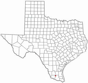
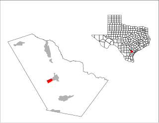
San Isidro is a census-designated place (CDP) in Starr County, Texas, United States. The population was 240 at the 2010 census. The town is named for St. Isidore the Laborer, the patron saint of farmers. A large Southwestern Barrel Cactus growing just east of town is said to be the largest in Texas.

San Diego is a city in Duval and Jim Wells counties, Texas, United States. The population was 3,748 at the 2020 census and 4,488 at the 2010 census. It is located primarily in Duval County, of which it is the county seat.
Briar is a census-designated place (CDP) in Parker, Tarrant and Wise counties in the U.S. state of Texas, near the west side of Eagle Mountain Lake.The population was 7,035 in 2020.

Castaic is an unincorporated community in the northwestern part of Los Angeles County, California, United States. As of the 2010 census it had a population of 19,015. For statistical purposes the Census Bureau has defined Castaic as a census-designated place (CDP).

Woodhouse, often known to locals as Old Woodhouse, is a small village and civil parish in the heart of Charnwood, England. The population of the civil parish at the 2011 census was 2,319, including around 300 term-time boarders at the Defence College. The parish includes the larger village of Woodhouse Eaves. The parish of Woodhouse was formed in 1844. The village is located between the larger Woodhouse Eaves and Quorn villages, the village contains a mixture of small cottages and large modern houses. It is a commuter village for both Leicester and Loughborough, as well as further afield.

Boulevard is a census-designated place (CDP) in the Mountain Empire area of southeastern San Diego County, California. At that time, it had a population of 359 at the 2020 United States census, up from 315 2010 United States census. The area is rural high desert along the Mexican border near the eastern extent of San Diego County.

Campo is an unincorporated community in the Mountain Empire area of southeastern San Diego County, California, United States. The population was 2,955 at the 2020 United States census, up from 2,684 at the 2010 census. For statistical purposes, the United States Census Bureau has defined Campo as a census-designated place (CDP). The census definition of the area may not precisely correspond to local understanding of the area with the same name.

The New Mexico Senate is the upper house of the New Mexico State Legislature. The Senate consists of 42 members, with each senator representing an equal number of single-member constituent districts across the state. All senatorial districts are divided to contain a population on average of 43,300 state residents. Members of the Senate are elected to four-year terms without term limits.

Brailsford is a small red-brick village and civil parish in Derbyshire on the A52 midway between Derby and Ashbourne. The parish also includes Brailsford Green. The civil parish population at the 2011 Census was 1,118. The village has a pub, a golf club, a post office and a school. There are many fine houses in the district including two 20th-century country houses: Brailsford Hall built in 1905 in Jacobean style, and Culland Hall.

East Langton railway station was opened by the Midland Railway on what is now the Midland Main Line, initially calling it simply Langton.

Winfield Township is one of nine townships in DuPage County, Illinois, USA. As of the 2020 census, its population was 45,836 and it contained 16,445 housing units. It is the least populous of the DuPage County Townships.

Lobley Hill is located in the west of the old County Borough of Gateshead within the Metropolitan Borough of Gateshead in Tyne and Wear, North East England having been previously part of the parish of Whickham.
Osleston is a hamlet which together with Thurvaston makes up the parish of Osleston and Thurvaston. The civil parish population at the 2011 Census was 267. It is 7.5 miles (12.1 km) north west of Derby.
Leming is a census-designated place (CDP) in Atascosa County, Texas, United States. As of the 2010 census, it had a population of 946. This was a new CDP for the 2010 census. The community is part of the San Antonio Metropolitan Statistical Area. Leming has a post office, with the ZIP code 78050.
Kumawu is a small town and is the capital of Sekyere Kumawu, a district in the Ashanti Region of Ghana. The town is known for the Tweneboa Kodua Secondary School. The school is a second cycle institution.

El Castillo is a census-designated place located in Starr County, Texas, United States. It is a new CDP, formed from part of the old La Victoria CDP for the 2010 census, with a population of 188.
