
The River Soar is a major tributary of the River Trent in the English East Midlands and is the principal river of Leicestershire. The source of the river is midway between Hinckley and Lutterworth. The river then flows north through Leicester, where it is joined by the Grand Union Canal. Continuing on through the Leicestershire Soar Valley, it passes Loughborough and Kegworth until it reaches the Trent at the county boundary. In the 18th century, the Soar was made navigable, initially between Loughborough and the Trent, and then through to Leicester. It was not until the early 19th century that it was linked by the Grand Union Canal to the wider network to the south and to London.

The Borough of Charnwood is a local government district with borough status in the north of Leicestershire, England, which has a population of 166,100 as of the 2011 census. It borders Melton to the east, Harborough to the south east, Leicester and Blaby to the south, Hinckley and Bosworth to the south west, North West Leicestershire to the west and Rushcliffe in Nottinghamshire to the north. It is named after Charnwood Forest, an area which the borough contains much of.

Bradgate Park is a public park in Charnwood Forest, in Leicestershire, England, northwest of Leicester. It covers 850 acres. The park lies between the villages of Newtown Linford, Anstey, Cropston, Woodhouse Eaves and Swithland. The River Lin runs through the park, flowing into Cropston Reservoir which was constructed on part of the park. To the north-east lies Swithland Wood. The park's two well known landmarks, Old John and the war memorial, both lie just above the 210 m (690 ft) contour. The park is part of the 399.3 hectare Bradgate Park and Cropston Reservoir Site of Special Scientific Interest, which has been designated under both biological and geological criteria.

Toney's Brook is a tributary of the Second River in Essex County, New Jersey in the United States.

The Leicester and Swannington Railway (L&S) was one of England's first railways, being opened on 17 July 1832 to bring coal from collieries in west Leicestershire to Leicester.

Anstey is a large village in Leicestershire, England, located north west of Leicester in the borough of Charnwood. Its population was 6,528 at the 2011 census. This figure is expected to increase due to the building of a new housing development off Groby Road. The village is separated from Leicester by the Rothley Brook, Castle Hill Park and the A46, and it borders the villages of Glenfield, Groby, Newtown Linford, Cropston and Thurcaston as well as the suburb of Beaumont Leys and Anstey Heights. To the north-west lies Bradgate Park.

Cropston is a village within the civil parish of Thurcaston & Cropston, part of the Borough of Charnwood in Leicestershire, England. It is on the edge of Charnwood Forest, and lies close to Bradgate Park.
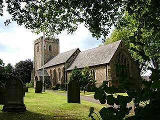
Thurcaston is a village in Leicestershire, England, in the parish of Thurcaston and Cropston. It is best known as the home to Bishop Hugh Latimer.

Beaumont Leys is a suburb and electoral ward in north-western Leicester, England. The population of the ward at the 2011 census was 16,480. Locally, Beaumont Leys is usually used in reference to the large housing estate, built within the administrative division, centred on Strasbourg Drive.

The Cedars Academy is a co-educational secondary school and sixth form located in Birstall in the English county of Leicestershire.

Mollidgewock Brook is a 12.6-mile-long (20.3 km) stream in northern New Hampshire and western Maine in the United States. It is a tributary of the Androscoggin River, which flows south and east into Maine, joining the Kennebec River near the Atlantic Ocean.

The River Bourne is the name given to a Thames tributary in northwest Surrey, England which has a longer tributary, the Windle Brook, that rises nears Bagshot Park in the south of Swinley Forest, Berkshire, merging with it while flowing through villages north of Woking; downstream the Bourne joins the Thames near Weybridge.
Thornton Reservoir is a small reservoir situated in the National Forest near the village of Thornton in Leicestershire. It has a surface area of 75 acres (300,000 m2) and a perimeter of 2.45 miles (3.94 km). It was originally built in 1854 when it had its own treatment works which were situated to the south of the current dam. It is now owned by Severn Trent and the water is treated a few miles away at Cropston Reservoir to which it runs via Rothley Brook. The reservoir is fed by two small streams which enter from the north via two weirs. Rothley Brook takes water away from the south.
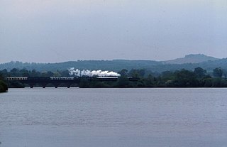
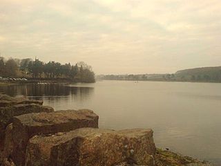
Swithland Reservoir is a reservoir in the English county of Leicestershire. It is north-east of the village of Swithland from which it takes its name, north-west of Rothley and approximately 133 metres (145 yd) south-west of Mountsorrel Quarry. It is part of the 187.1-hectare (462-acre) Buddon Wood and Swithland Reservoir Site of Special Scientific Interest (SSSI).
The Martin High School is a coeducational secondary school with academy status, located in the village of Anstey, Leicestershire, on the outskirts of Leicester. The school accepts students from nearby Beaumont Leys, Glenfield, Thurcaston and Cropston as well as some students from New Parks and Braunstone.

The River Lin is a river which runs through North Leicestershire. The source of the river is in Ulverscroft, near Charnwood Forest. The river runs through Bradgate Park before the river runs into the River Soar in Quorn. The river also feeds Cropston Reservoir and Swithland Reservoir. The river runs for around 17 kilometres between its source and confluence with the River Soar. The river is described as one of Leicestershire's shortest rivers.

