
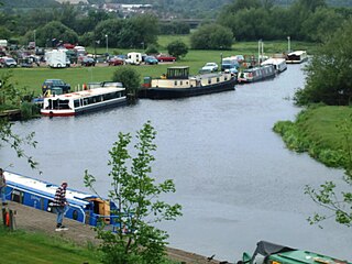
The River Soar is a major tributary of the River Trent in the English East Midlands and is the principal river of Leicestershire. The source of the river is midway between Hinckley and Lutterworth. The river then flows north through Leicester, where it is joined by the Grand Union Canal. Continuing on through the Leicestershire Soar Valley, it passes Loughborough and Kegworth until it reaches the Trent at the county boundary. In the 18th century, the Soar was made navigable, initially between Loughborough and the Trent, and then through to Leicester. It was not until the early 19th century that it was linked by the Grand Union Canal to the wider network to the south and to London.

Rushcliffe is a local government district with borough status in Nottinghamshire, England. The population of the Local Authority at the 2011 Census was 111,129. Its council, Rushcliffe Borough Council(0115 981 9911), is based in West Bridgford. It was formed on 1 April 1974 by merging the West Bridgford Urban District, the Bingham Rural District and part of Basford Rural District.

Sutton Bonington is a village and civil parish lying along the valley of the River Soar in the Borough of Rushcliffe, south-west Nottinghamshire, England. The University of Nottingham has a 420 hectares (4.2 km2) site just to the north of the village: Sutton Bonington Campus.
The Soar Valley in Leicester- and Nottinghamshire, England is the basin of the River Soar, which rises south of Leicester and flows north through Charnwood before meeting the River Trent at Trent Lock.

Rushcliffe is a constituency represented in the House of Commons of the UK Parliament from 2019 by Ruth Edwards, a Conservative.

Normanton on Soar, formerly known as Normanton-upon-Soar and known locally as Normanton, is a village and civil parish in the south of Nottinghamshire in England near the River Soar. This historic village is home to one of the last operating chain ferries in the country, the only lived in cruck building in Nottinghamshire and a 13th-century Grade I listed parish Church.

Kingston on Soar is a village and civil parish in the Rushcliffe borough of Nottinghamshire, England.

East Leake is a large village and civil parish in the Rushcliffe district of Nottinghamshire, England, although its closest town and postal address is Loughborough in Leicestershire. It has a population of around 7,000, measured in the 2011 Census as 6,337. The original village was located on the Sheepwash Brook. Kingston Brook also runs through the village. Near the centre of the village is the historic St. Mary's Church, dating back to the 11th century, which Sheepwash Brook flows past, and an old ford, which provided access to the pinfold. The church has six bells.

Stanford on Soar, known locally as Stanford, is a village and civil parish in the south of Nottinghamshire in England near the River Soar. Stanford on Soar is the most southerly civil parish in Nottinghamshire.

West Leake is a small conservation village and civil parish in the Rushcliffe district of Nottinghamshire.

The Eye Brook is a watercourse in the East Midlands of England and a tributary of the River Welland. It is around 18 miles (29 km) long.

Rushcliffe was a wapentake of the historic county of Nottinghamshire, England. It was in the south of the county, on the south side of the River Trent, covering the parishes of Barton in Fabis, Bradmore, Bunny, Clifton with Glapton, Costock, East Leake, Edwalton, Gotham, Keyworth, Kingston on Soar, Normanton on Soar, Plumtree, Ratcliffe on Soar, Rempstone, Ruddington, Stanford on Soar, Stanton-on-the-Wolds, Sutton Bonington, Thorpe in the Glebe, Thrumpton, West Leake, Widmerpool, Wilford, Willoughby on the Wolds and Wysall.
South East Derbyshire was a rural district in Derbyshire, England from 1894 to 1974. It covered an area to the south-east of Derby.
Leake was a rural district in Nottinghamshire, England from 1894 to 1935.

Rempstone is a village and civil parish in the Rushcliffe district of Nottinghamshire, although its closest town and postal address is Loughborough across the border in Leicestershire. The population of the civil parish at the 2011 census was 367. It is situated at the crossing of the A60 and A6006 roads. It has no schools. Rempston is mentioned in the 1086 Domesday Book.

The River Swift is a 14-mile (23 km) long tributary of the River Avon that rises in south Leicestershire, and flows through the town of Lutterworth before joining the Avon at its confluence at Rugby in Warwickshire in the English Midlands.

Fairham Brook is a 16-mile-long (26 km) tributary of the River Trent that flows through Leicestershire and Nottinghamshire in England.

The River Lin is a river which runs through North Leicestershire. The source of the river is in Ulverscroft, near Charnwood Forest. The river runs through Bradgate Park before the river runs into the River Soar in Quorn. The river also feeds Cropston Reservoir and Swithland Reservoir. The river runs for around 17 kilometres between its source and confluence with the River Soar. The river is described as one of Leicestershire's shortest rivers.

The Whissendine Brook is a small watercourse in the East Midlands region of England. It is a tributary of the Langham Brook and part of the River Soar catchment.

The Langham Brook is a watercourse in the East Midlands of England. It is a tributary of the River Eye and part of the River Soar catchment.
