Woolsthorpe by Belvoir, also known as Woolsthorpe is a village and civil parish in the South Kesteven district of Lincolnshire, England. The population of the civil parish at the 2011 census was 415. It is situated approximately 5 miles (8 km) west from Grantham, and adjoins the county border with Leicestershire. The neighbouring village of Belvoir lies on the other side of the border. Grantham Canal is situated 1 mile (1.6 km) to the north-east at its closest point.

Melton Mowbray is a town in the Melton district in Leicestershire, England, 19 miles (31 km) north-east of Leicester, and 20 miles (32 km) south-east of Nottingham. It lies on the River Eye, known below Melton as the Wreake. The town had a population of 27,670 in 2019. The town is sometimes promoted as Britain's "Rural Capital of Food"; it is the home of the Melton Mowbray pork pie and is the location of one of six licensed makers of Stilton cheese.

Buckminster is a village and civil parish within the Melton district of Leicestershire, England, which includes the two villages of Buckminster and Sewstern. The total population of the civil parish was 335 at the 2021 census. It is on the B676 road, 10 miles east of Melton Mowbray and 4 miles west of the A1 at Colsterworth.

Hellidon is a village and civil parish about 5 miles (8 km) south-west of Daventry in Northamptonshire, England. The parish area is about 1,600 acres (650 ha). It lies 520 feet (160 m) – 590 feet (180 m) above sea level on the north face of an ironstone ridge, its highest point, 670 feet (200 m) at Windmill Hill, being 0.5 miles (800 m) south-east of the village. The Leam and tributaries rise in the parish. The 2011 Census gave a population of 256, estimated at 286 in 2019. The long-distance Jurassic Way footpath linking Banbury, Oxfordshire, and Stamford, Lincolnshire, passes through. The origin of the name is unclear. "Holy Valley", "Haegla's Valley" and "Unstable valley" have been suggested, with the Old English "dun", meaning hill.

Denton is a village and civil parish in the South Kesteven district of Lincolnshire, England. The population of the civil parish was 273 at the 2011 census. It is situated approximately 3 miles (5 km) both south-west of Grantham and west from the A1 road.

Ibstock is a former coal mining town and civil parish about 3 miles (5 km) south of Coalville in North West Leicestershire, England. The population of the civil parish was 5,760 at the 2001 census increasing to 6,201 at the 2011 census.

Ullesthorpe is a small village and civil parish situated in the Harborough district in southern Leicestershire. Ullesthorpe is noted for its historic background with a mill, disused railway station and traces of a medieval settlement evident on the edge of the village.

Freeby is a village and civil parish in the Melton district of Leicestershire, England, about 3 miles (5 km) east of Melton Mowbray. As well as the village of Freeby the civil parish includes the villages of Brentingby, Saxby, Stapleford and Wyfordby. The 2011 Census recorded the parish population as 244.

Allington is a village and civil parish in the South Kesteven district of Lincolnshire, England, 3 miles (5 km) north-west of Grantham. The 2001 census gave a parish population of 728 in 329 households. The population increased to 897 in 422 households in the 2011 census.
North Hykeham is a town and civil parish in the North Kesteven district, in the county of Lincolnshire, England. It forms part of the Lincoln Urban Area. The population of the town at the 2011 census was 13,884.

South Witham is a village and civil parish in the South Kesteven district of Lincolnshire, England. The population of the civil parish at the 2011 census was 1,533. It is situated 10 miles (16 km) south of Grantham, 10 miles east of Melton Mowbray and 10 miles (16 km) north of Oakham. The village is close to the Leicestershire and Rutland borders.

Castle Bytham is a village and civil parish of around 300 houses in South Kesteven, Lincolnshire, England. It is located 9 miles (14 km) north of Stamford and 9 miles (14 km) west of Bourne.The population was measured at 768 in 317 households at the 2011 census.

Overseal is a village and civil parish in South Derbyshire district of Derbyshire, England. It is 3 miles (4.8 km) south of Swadlincote, 5 miles (8.0 km) west of Ashby-de-la-Zouch and 13 miles (21 km) south-southwest of Derby. It had a population of the civil parish at the 2011 census was 2,450. Situated within the National Forest area, it is near the villages of Netherseal and Lullington as well as being close to the border with Leicestershire. It is one of the southernmost settlements in Derbyshire.

Muston is a village and former civil parish, now in the parish of Bottesford, in the Melton district, in north-east Leicestershire, England. It is 18.6 miles (29.9 km) east of Nottingham, five miles (8.0 km) west of Grantham on the A52 and 12.5 miles (20.1 km) north of Melton Mowbray. It lies on the Leicestershire/Lincolnshire county border, two miles east of Bottesford. The River Devon flows through the village. In 1931 the parish had a population of 218. On 1 April 1936 the parish was abolished and merged with Bottesford.
Edmondthorpe is a small village and former civil parish, now in the parish of Wymondham, in the Melton district, in the county of Leicestershire, England, close to the border with Rutland. In 1931 the parish had a population of 195.

South Witham railway station was a station in South Witham, Lincolnshire on the Midland Railway. It was Midland Railway property but train services were operated by the Midland and Great Northern Joint Railway. It was closed in 1959 along with most of the M&GN.

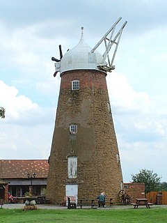
Whissendine railway station was a station serving the villages of Whissendine in Rutland and Wymondham and Edmondthorpe in Leicestershire. The station itself was about one and a half miles from each, and was in Leicestershire. It opened in 1848 on the Syston and Peterborough Railway and was originally named Wymondham but by 1863 it had been renamed Whisendine.

Saxby All Saints is a village and civil parish in North Lincolnshire, England. The population of the civil parish at the 2011 census was 385. It is 6 miles (9.7 km) north of Brigg and 4 miles (6.4 km) south-west of Barton upon Humber.

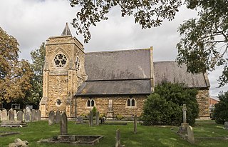
St Michael and All Angels Church is a redundant Anglican church in the village of Edmondthorpe, Leicestershire, England. It is recorded in the National Heritage List for England as a designated Grade I listed building, and is under the care of the Churches Conservation Trust.

Sir Thomas Berkeley of Wymondham, Leicestershire was an English lawyer, soldier and politician. He represented Leicestershire in Parliament and served as Sheriff for Rutland, Warwickshire and Leicestershire.