
Leicestershire is a landlocked county in the English Midlands, being within the East Midlands. The county borders Nottinghamshire to the north, Lincolnshire to the north-east, Rutland to the east, Northamptonshire to the south-east, Warwickshire to the south-west, Staffordshire to the west, and Derbyshire to the north-west. The border with most of Warwickshire is Watling Street, the modern A5 road.

The River Welland is a lowland river in the east of England, some 65 miles (105 km) long. It drains part of the Midlands eastwards to The Wash. The river rises in the Hothorpe Hills, at Sibbertoft in Northamptonshire, then flows generally northeast to Market Harborough, Stamford and Spalding, to reach The Wash near Fosdyke. It is a major waterway across the part of the Fens called South Holland, and is one of the Fenland rivers which were laid out with washlands. There are two channels between widely spaced embankments with the intention that flood waters would have space in which to spread while the tide in the estuary prevented free egress. However, after the floods of 1947, new works such as the Coronation Channel were constructed to control flooding in Spalding and the washes are no longer used solely as pasture, but may be used for arable farming.

Naseby is a village in West Northamptonshire, England. The population of the civil parish at the 2011 Census was 687.

Market Harborough is a market town in the Harborough district of Leicestershire, England, in the far southeast of the county, forming part of the border with Northamptonshire.
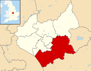
Harborough is a local government district of Leicestershire, England, named after its main town, Market Harborough. Covering 230 square miles (600 km2), the district is by far the largest of the eight district authorities in Leicestershire and covers almost a quarter of the county.
This article is intended to give an overview of the history of Leicestershire.

Harborough is a constituency covering the south east of Leicestershire represented in the House of Commons of the UK Parliament since 2017 by Neil O'Brien of the Conservative Party.

Great Bowden is a village and civil parish in the Harborough district of Leicestershire, England. It is north-east of and a suburb of Market Harborough, although originally the parish of Great Bowden included Harborough. The population is around 1,000, being measured at the 2011 census as 1,017. Places nearby include Market Harborough, Little Bowden, Sutton Bassett, Foxton and Thorpe Langton.

Welham is a small village and civil parish in the Harborough district of Leicestershire, England. Welham lies 4 miles (6 km) north-east of Market Harborough. The village is situated on the north bank of the River Welland, which forms the border with the neighbouring county of Northamptonshire. The population is included in the civil parish of Slawston.

Little Bowden is an area on the edge of Market Harborough, Leicestershire, England. As a village it was formerly part of Northamptonshire. The River Jordan runs through part of the area. Now, it's been integrated into Market Harborough and is fully part of the town using the town's address of 'Market Harborough'. The population is included in the civil parish of Stoke Albany.

Brampton Ash is a civil parish and village in Northamptonshire, England. It lies in the extreme north-west of Northamptonshire and the nearest urban settlements are the nearby towns of Corby, Kettering, Desborough and Market Harborough. Running past the north of the village is the A427 road which connects Market Harborough to Oundle. At the 2011 census the population of the village was included in the civil parish of Stoke Albany.

Theddingworth is a village and civil parish in Leicestershire, England. The population of the civil parish at the 2011 census was 217. The parish includes the neighbouring hamlet of Hothorpe, which lies across the county boundary in Northamptonshire.
The Rugby and Stamford Railway was an early railway in England built in 1850. The London and Birmingham Railway had already built a branch from Blisworth to serve Northampton and extend to Peterborough. The success of this, the Northampton and Peterborough Railway encouraged the directors to look for other ventures. They decided upon a branch from Rugby to Stamford which would link up with other new railways in the east of the country.

Harborough Museum was opened in 1983 in the former R & W H Symington corset factory that also houses the Harborough District Council offices in the historic market town of Market Harborough. It is run by a partnership between Leicestershire County Council, Harborough District Council and Market Harborough Historical Society. Since 2014, its affairs have been overseen by a new charitable organisation, the Harborough Museum Trust.

Great Bowden Borrowpit is a 2.4 hectare biological Site of Special Scientific Interest north of Market Harborough in Leicestershire.
St Mary in Arden Church is a ruined church on Bowden Road in Market Harborough, England. Although it was established before the 13th century, the Grade II listed remains are part of the later 17th-century church built on the same site.

