Related Research Articles

Northampton is a market town and civil parish in the East Midlands of England, on the River Nene, 60 miles (97 km) north-west of London and 50 miles (80 km) south-east of Birmingham. It is the historic county town of Northamptonshire, but since local government changes in 2021, it has been the administrative centre of the unitary authority of West Northamptonshire. Northampton is one of the largest towns in England; In the 2021 census its urban area had a population of 245,899, increased from 215,273 at the 2011 census.
The River Nene is a river in the east of England that rises from three sources in Northamptonshire. The river is about 105 miles (169 km) long, about 3.7 miles (6.0 km) of which forms the border between Cambridgeshire and Norfolk. It is the tenth-longest river in the United Kingdom, and is navigable for 88 miles (142 km), from Northampton to The Wash.

The Hogsmill River in Surrey and Greater London, England is a small chalk stream tributary of the River Thames. It rises in Ewell and flows into the Thames at Kingston upon Thames on the lowest non-tidal reach, that above Teddington Lock.
Wootton is a former village about 3 miles (4.8 km) south of Northampton town centre that is now part of Northampton.

Northampton South is a constituency represented in the House of Commons of the UK Parliament since 2017 by Andrew Lewer, a Conservative.

The Monarch's Way is a 625-mile (1,006 km) long-distance footpath in England that approximates the escape route taken by King Charles II in 1651 after being defeated in the Battle of Worcester. It runs from Worcester via Bristol and Yeovil to Shoreham, West Sussex.
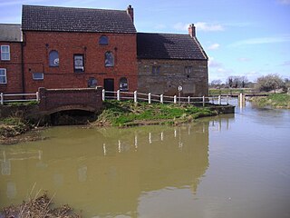
Rothersthorpe is a small village of medieval origin, in West Northamptonshire, England, with a population of 500 in the 2001 Census, reducing to 472 at the 2011 census. It is 4 miles (6 km) from the town of Northampton.

The A43 is a primary route in the English Midlands and northern South East England, that runs from the M40 motorway near Ardley in Oxfordshire to Stamford in Lincolnshire. Through Northamptonshire it bypasses the towns of Northampton, Kettering and Corby which are the three principal destinations on the A43 route. The A43 also links to the M1 motorway.

South Northamptonshire is a constituency represented in the House of Commons of the UK Parliament since its 2010 recreation by Andrea Leadsom, a Conservative who served as Secretary of State for Business, Energy and Industrial Strategy until 13 February 2020. She was Leader of the House of Commons from 2017 to 2019, and Secretary of State for Environment, Food and Rural Affairs from 2016 to 2017. The seat of South Northamptonshire is considered a Conservative safe seat with having elected a Conservative MP at every election for 110 Years. Current Conservative MP Andrea Leadsom was re-elected in 2019 with an increased majority.

Piddington is a village in the south of the English shire county of Northamptonshire and just north of Buckinghamshire. It is 6 miles (10 km) south of Northampton town centre, in a cul-de-sac off the main road at the War Memorial in the village of Hackleton, and about 1 mile (2 km) south-west of there. It has a geographic size of 1,693 acres (6.85 km2) and an average height of 300 ft (91 m), rising steadily to 400 ft (120 m) in Salcey Forest.
West Hunsbury is a large housing estate in the south of the town of Northampton, 2 miles (3 km) from the town centre, 0 miles (0 km) from the M1 motorway, junction 15A and 2 miles (3 km) from junction 15. The motorway can be seen and heard as most of the area is elevated and the wind's prevailing direction is westerly. It is part of the Hunsbury residential area, which also constitutes East Hunsbury east of Towcester Road. Shelfleys is an earlier name for the area and still appears on signs, maps and bus destination indicators. However Hunsbury is an old name. Iron ore was formerly quarried in the area. This had begun by 1873 and an ironworks called Hunsbury Ironworks was in the course of being built in that year. The quarries were worked by several companies and individual owners, two of which companies used the name "Hunsbury" in their titles. The area is part of the Borough of Northampton. The area was developed in the 1970s, 1980s, 1990s and 2000s as part of the expansion of Northampton.
Collingtree is a village and civil parish in the West Northamptonshire district of Northamptonshire, England. It is part of the Northampton built-up area.

East Hunsbury is a large residential area in the south of the town of Northampton, England, 3 miles (5 km) from the town centre and 1 mile (2 km) from junction 15 of the M1 motorway. For administrative purposes it is part of the unitary authority of West Northamptonshire. It is part of the Hunsbury residential area, which also includes West Hunsbury on the west side of Towcester Road. Shelfleys is the original name for the area of Northampton currently referred to as West Hunsbury. The name of West Hunsbury still appears on maps for the district as Shelfleys. Merefield is the corresponding name for East Hunsbury, together with the name "Blackymore" for the eastern part of East Hunsbury. All three names are still on local direction signs in Northampton, although older references are no longer in use by the local people living there. The areas developed in the 1980s and 1990s as part of the expansion of Northampton. The Northampton loop of the West Coast Main Line railway running between Northampton and London Euston runs under East and West Hunsbury via the Hunsbury Hill Tunnel emerging near Hill Farm Rise which follows the original course of Towcester Road prior to the 1980s. Ventilation shafts are visible in the housing estate in Yeoman Meadow. East Hunsbury was awarded ‘Best Large Village’ in 2019 by NorthantsAcre.

The Babingley is a minor river in the northwest of the county Norfolk in England. It runs 12.2 miles (19.6 km) from its source at the village of Flitcham to the River Great Ouse at Wootton Marshes where it terminates.
Collingtree Park is a district in the Borough of Northampton in the East Midlands of England.

Far Cotton is a district in the civil parish of Far Cotton and Delapre, in the town of Northampton, in the county of Northamptonshire, England and many years ago a village in its own right.

Piddington was a railway station on the former Bedford to Northampton Line. Despite its name, the station was located close to the village of Horton in Northamptonshire, approximately 2 miles (3.2 km) from the village of Piddington.

Salcey Forest railway station was a short-lived railway station in England, on the Stratford-upon-Avon, Towcester and Midland Junction Railway which opened on 1 December 1892 near the Northamptonshire forest of the same name. The station was not situated near any settlement and only saw passenger services for four months, it being most likely an error of judgement by the railway company which had provided substantial station facilities in expectation of traffic which never came. Salcey Forest station eventually closed on 31 March 1893 and has an arguable claim, along with Stoke Bruerne, of having had the shortest passenger service ever provided at any British railway station. Goods facilities were withdrawn in 1952.

Victoria Park is a public green space in St. James End, Northampton, England, south of Spencer Bridge Road. The park has open grass areas and lines and belts of trees. A stream, a tributary of the River Nene flows from north to south through the park on the east side next to the railway line. A small stream, Dallington Brook, also flows through the park from the north-west joining the Nene tributary. The park has an area of about 6.5 hectares.
References
- ↑ Ordnance Survey OS Explorer Map sheet 223, Northampton & Market Harborough, Brixworth & Pitsford Water. ISBN 978-0-319-23735-9
Coordinates: 52°13′24″N0°56′32″W / 52.2234°N 0.9422°W
| | This Northamptonshire location article is a stub. You can help Wikipedia by expanding it. |