Barlings Eau

Last updated

Barlings Eau
Barlingseau.jpg
Barlings Eau to the west of Stainton by Langworth
Location
Country England
Counties Lincolnshire
Physical characteristics
Source 
  location Cold Hanworth
Mouth  
  location
Short Ferry
Basin features
Tributaries 
  leftLegsby Beck, Stainton Beck, Goltho Beck, Stainfield Beck
  right Welton Beck, Nettleham Beck, Scothern Beck
Barlings Eau
BSicon uexSTR+l.svg
BSicon uexSTRq.svg
BSicon uexKHSTeq.svg
Faldingworth Beck
BSicon uexKHSTa.svg
BSicon uexSTR.svg
BSicon uexKHSTa.svg
Sources
BSicon uexSKRZ-Yu.svg
Spridlington Road
BSicon uexSTRl.svg
BSicon uexABZg+lr.svg
BSicon uexSTRr.svg
BSicon uexSTR+FEATURE@r.svg
Cold Hanworth medieval settlement
BSicon uexSTRl.svg
BSicon uexSTR+r.svg
BSicon uexSKRZ-Au.svg
A46 Snarford Bridge
BSicon uexABZg+l.svg
BSicon uexSTRq.svg
Legsby Beck
BSicon uexSTRq.svg
BSicon uexSTRq.svg
BSicon uexABZg+r.svg
Welton Beck
BSicon uexSTRq.svg
BSicon uexSTRq.svg
BSicon uexABZg+r.svg
Scothern Beck
BSicon uexSKRZ-Yu.svg
Stainton Lane Bridge
BSicon uxmKRZu.svg
Lincoln - Market Rasen railway
BSicon uexABZg+l.svg
BSicon uexSTRq.svg
Stainton Beck
BSicon uexSTRq.svg
BSicon uexSTRq.svg
BSicon uexABZg+r.svg
Nettleham Beck
BSicon uexSKRZ-Au.svg
A158 Langworth Bridge
BSicon uexABZg+l.svg
BSicon uexSTRq.svg
Goltho Beck
BSicon uexSTR+FEATURE@r.svg
Barlings Abbey
BSicon uexABZg+l.svg
BSicon uexSTRq.svg
Stainfield Beck
BSicon utCONTg.svg
BSicon uexSTR.svg
Pipeline to River Ancholme
BSicon utSTRl.svg
BSicon uxSTRbl.svg
Pumping station (EA)
BSicon uexSKRZ-Yu.svg
Short Ferry Bridge
BSicon uSTR+r.svg
BSicon uSTRbr.svg
BSicon uexSTRq.svg
Stainfield pumping station (IDB)
BSicon uSTR.svg
BSicon uexKBHFaq.svg
BSicon ugFABZgr+r.svg
Former marina
BSicon uWEIRr.svg
BSicon uexSTRq.svg
BSicon uxABZql.svg
BSicon uSTR+r.svg
Old River Witham
BSicon uFGATEu.svg
BSicon uSTR.svg
Bardney Lock
BSicon uFABZgl+l.svg
BSicon uSTRq.svg
BSicon uSTRq.svg
BSicon uSTRr.svg
BSicon uSTR.svg
River Witham

Barlings Eau is a small river near Barlings, Lincolnshire, England. It is a tributary of the River Witham, joining it near Short Ferry. It acts as the central spine for a number of other small rivers, which drain the low-lying land to either side. Most of its course is within the area managed by the Witham Third District IDB, an Internal Drainage Board responsible for land drainage. One of their pumping stations is on the banks of the river.

Contents

There is also an Environment Agency pumping station, which is used to pump water from the River Witham system to the River Ancholme, to maintain flows and water quality when required.

Route

Barlings Eau rises as three streams which join near the medieval village of Cold Hanworth. One rises to the east of Spridlington and flows in a south-easterly direction. A second rises to the north of Faldingworth, flows to the west under the A46 road, and then turns to the south. A third rises to the west of Faldingworth, and again flows west and south to the junction. The first is below the 50-foot (15 m) contour, while the other two start above the 65-foot (20 m) contour. The second one is known as Faldingworth Beck by the Environment Agency, and runs down to Snarford Bridge, but is labelled Barlings Eau on the Ordnance Survey map. At Snarford, it is joined by two other streams from the west, and passes under the A46 at Snarford Bridge. [1]

Below the bridge, it is joined on the left bank by Legsby Beck, which rises in Legsby Wood, to the east of Linwood, and flows in a south-western direction between Faldingworth and Friesthorpe. Welton Beck begins at Old Man's Head Spring, and flows through Welton and Dunholme to join on the right bank. Scothern Beck rises to the west of Scothern, and flows easterly through the village to reach the right bank. When it reaches Stainton by Langworth, it passes under a minor road to Scothern and the Lincoln to Market Rasen railway. [1]

Stainton Beck begins near the higher ground at Sixhills, and flows past Legsby, Lissington, Wickenby, Snelland, and Stainton to join on the left, while Nettleham Beck rises near Lincolnshire Showground, and passes through the university complex at Riseholme, Nettleham, and Sudbrooke to join on the right near Langworth. Barlings Eau passes under the A158 road, crosses Newball Common, and flows along the eastern edge of Barlings Abbey. [1] The Abbey was founded by the Premonstratensian order, known in Britain as the White Canons, in 1156. The remains are quite fragmentary, but parts of the Abbey Church are grade I listed [2] and the remains of the Abbey are grade II listed. The site is a Scheduled Ancient Monument. [3] Two more tributaries join on the let bank, Goltho Beck before the abbey, and Stainfield Beck after it. Just before the river crosses under Ferry Road at Short Ferry Bridge, there is a large Environment Agency pumping station, and a small electric pumping station maintained by the Witham Third District Internal Drainage Board below it. Finally, the river joins the old course of the River Witham, which joins the new course just below Bardney Lock. [1] The old course and the start of Barlings Eau up to Short Ferry Bridge is navigable, and there was a marina at Short Ferry, but the connection to the river channel has been filled in. The former basin is now a lake in a caravan park. [4]

Land drainage

With the exception of a tiny section of two of the streams at the source of the river, its entire course lies within the jurisdiction of the Witham Third District Internal Drainage Board. The upper reaches to below Snarford Bridge and most of the tributaries below that are maintained by the Drainage Board. [5] The main channel below Snarford is a designated main river and is the responsibility of the Environment Agency. The Board was originally constituted by an Act of Parliament passed in 1762, which created six drainage districts, with responsibility for Draining and Preserving certain Low Lands, called the Fens, lying on both Sides of the River Witham, in the County of Lincoln. On 1 November 1934, the Witham Third District Commissioners amalgamated with the Bardney Drainage Board, the Greetwell District Drainage Commissioners, the Kirkstead Drainage Board, and the River Bain Drainage Board, as a result of the passing of the Land Drainage Act of 1930. The Board was again re-organised following the passing of the Land Drainage Act of 1991, and now consists of 31 members, 15 who are elected by those who pay drainage rates, 14 nominated by councils, and two joint appointments. They are responsible for the drainage of an area which covers 54 square miles (140 km2). [6]

The area around Short Ferry is called Stainfield Fen, and it was first drained as a private venture by landowners. It became part of the Greetwell Drainage District, and a 16 hp (12 kW) steam engine was installed some time before 1881. This was replaced by a 30 hp (22 kW) engine in 1896, which had been scrapped by 1953. There are now no traces of the original buildings, [7] which were located close to the junction with the old course of the Witham. [8] The present Stainfield pumping station, which is situated next to Short Ferry Bridge, contains a 20-inch (51 cm) Allen-Gwynnes electric pump, which was installed in 1959, and which can pump 9.7 million gallons per day (44 Megalitres per day (Mld)). [9] In 1991 this was supplemented by two 10-inch (254 mm) submersible pumps, each capable of pumping 1.1M gal per day (5 Mld), [10] which are located a little to the south-east of the 1959 station.

Water transfer

Short Ferry pumping station pumps water to the River Ancholme to maintain its flow. Environment Agency Building - geograph.org.uk - 589233.jpg
Short Ferry pumping station pumps water to the River Ancholme to maintain its flow.

Just above Short Ferry bridge, the Environment Agency maintain Short Ferry pumping station, which forms part of the Trent Witham Ancholme Transfer Scheme. This is designed to manage flows and levels in the River Ancholme during dry weather and the summer months, so that the large volume abstracted from the river, particularly for the public drinking water supply, can be maintained, and the water quality is not compromised by ingress of salt water from the Humber. The pumping station pumps water through an 11-mile (18 km) pipeline to Toft Newton reservoir, on the upper reaches of the Ancholme. The reservoir covers an area of 41 acres (16.5 ha) and can hold enough water to maintain the Ancholme for up to seven days, in the event of a failure of the pumps at Short Ferry. [11]

If flows in Barlings Eau or the Witham are insufficient to supply the required volumes, extra water is delivered to the Witham by Trent pumping station, near Torksey Lock. This pumps water through a short pipeline and into the Foss Dyke. It then flows for 10.8 miles (17.4 km) along the Foss Dyke to Brayford Pool and so into the Witham, to supplement the water available for pumping. The scheme was commissioned in 1974, and the volume of water transferred varies with the weather conditions. In 1987, it was 2,425 megalitres (533×10^6 imp gal), while in 1979 it was 17,425 megalitres (3,833×10^6 imp gal). [12]

Water quality

The Environment Agency measures the water quality of the river systems in England. Each is given an overall ecological status, which may be one of five levels: high, good, moderate, poor and bad. There are several components that are used to determine this, including biological status, which looks at the quantity and varieties of invertebrates, angiosperms and fish. Chemical status compares the concentrations of various chemicals against known safe concentrations and is rated good or fail. Barlings Eau and all of its tributaries are designated as "heavily modified", which means that the channels have been altered by human activity, and the criteria for this designation are defined by the Water Framework Directive. [13]

The water quality of the Barlings Eau system was as follows in 2019.

SectionEcological StatusChemical StatusLengthCatchmentChannel
Barlings Eau – Upper [14] Moderate Fail 5.3 miles (8.5 km)9.00 square miles (23.3 km2)heavily modified
Faldingworth Beck [15] Moderate Fail 5.0 miles (8.0 km)10.90 square miles (28.2 km2)heavily modified
Scothern Beck [16] Poor Fail 4.6 miles (7.4 km)5.79 square miles (15.0 km2)heavily modified
Legsby (Lissington) Beck [17] Moderate Fail 8.6 miles (13.8 km)10.82 square miles (28.0 km2)heavily modified
Nettleham Beck [18] Moderate Fail 7.9 miles (12.7 km)9.82 square miles (25.4 km2)heavily modified
Goltho Beck [19] Moderate Fail 4.6 miles (7.4 km)5.39 square miles (14.0 km2)heavily modified
Stainfield Beck [20] Moderate Fail 6.2 miles (10.0 km)7.21 square miles (18.7 km2)heavily modified
Barlings Eau [21] Moderate Fail 8.6 miles (13.8 km)44.46 square miles (115.2 km2)heavily modified

Like many rivers in the UK, the chemical status changed from good to fail in 2019, due to the presence of polybrominated diphenyl ethers (PBDE) and mercury compounds, neither of which had previously been included in the assessment.

Points of interest

Map all coordinates using: OpenStreetMap

Bibliography

Related Research Articles

<span class="mw-page-title-main">River Witham</span> River in eastern England

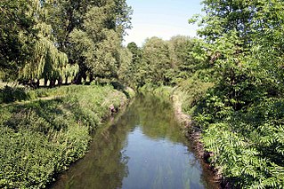
The River Witham is a river almost entirely in the county of Lincolnshire in the east of England. It rises south of Grantham close to South Witham at SK8818, passes through the centre of Grantham, passes Lincoln at SK9771 and at Boston, TF3244, flows into The Haven, a tidal arm of The Wash, near RSPB Frampton Marsh. The name "Witham" seems to be extremely old and of unknown origin. Archaeological and documentary evidence shows the importance of the Witham as a navigable river from the Iron Age onwards. From Roman times it was navigable to Lincoln, from where the Fossdyke was constructed to link it to the River Trent. The mouth of the river moved in 1014 following severe flooding, and Boston became important as a port.

<span class="mw-page-title-main">River Ancholme</span> River in Lincolnshire, England

The River Ancholme is a river in Lincolnshire, England, and a tributary of the Humber. It rises at Ancholme Head, a spring just north of the village of Ingham and immediately west of the Roman Road, Ermine Street. It flows east and then north to Bishopbridge west of Market Rasen, where it is joined by the Rase. North of there it flows through the market town of Brigg before draining into the Humber at South Ferriby. It drains a large part of northern Lincolnshire between the Trent and the North Sea.

<span class="mw-page-title-main">River Wissey</span> River in Norfolk, England

The River Wissey is a river in Norfolk, eastern England. It rises near Bradenham, and flows for nearly 31 miles (50 km) to join the River Great Ouse at Fordham. The lower 11.2 miles (18.0 km) are navigable. The upper reaches are notable for a number of buildings of historic interest, which are close to the banks. The river passes through the parkland of the Arts and Crafts Pickenham Hall, and further downstream, flows through the Army's Stanford Training Area (STANTA), which was created in 1942 by evacuating six villages. The water provided power for at least two mills, at Hilborough and Northwold. At Whittington, the river becomes navigable, and is surrounded by fenland. A number of pumping stations pump water from drainage ditches into the higher river channel.

<span class="mw-page-title-main">River Glen, Lincolnshire</span> River in Lincolnshire and Rutland, England

The River Glen is a river in Lincolnshire, England with a short stretch passing through Rutland near Essendine.

<span class="mw-page-title-main">Foss Dyke</span> Canal that connects the River Trent to Lincoln

The Foss Dyke, or Fossdyke, connects the River Trent at Torksey to Lincoln, the county town of Lincolnshire, and may be the oldest canal in England that is still in use. It is usually thought to have been built around AD 120 by the Romans, but there is no consensus among authors. It was refurbished in 1121, during the reign of King Henry I, and responsibility for its maintenance was transferred to the city of Lincoln by King James I. Improvements made in 1671 included a navigable sluice or lock at Torksey, and warehousing and wharves were built at Brayford Pool in the centre of Lincoln.

<span class="mw-page-title-main">River Rother, East Sussex</span> River in East Sussex and Kent, England

The River Rother flows for 35 miles (56 km) through the English counties of East Sussex and Kent. Its source is near Rotherfield in East Sussex, and its mouth is on Rye Bay, part of the English Channel. Prior to 1287, its mouth was further to the east at New Romney, but it changed its course after a great storm blocked its exit to the sea. It was known as the Limen until the sixteenth century. For the final 14 miles (23 km), the river bed is below the high tide level, and Scots Float sluice is used to control levels. It prevents salt water entering the river system at high tides, and retains water in the river during the summer months to ensure the health of the surrounding marsh habitat. Below the sluice, the river is tidal for 3.7 miles (6.0 km).

<span class="mw-page-title-main">River Idle</span> River in Nottinghamshire, England

The River Idle is a river in Nottinghamshire, England whose source is the confluence of the River Maun and River Meden near Markham Moor. The Idle flows north from its source through Retford and Bawtry before entering the River Trent at West Stockwith. Its main tributaries are the River Poulter and the River Ryton. The river is navigable to Bawtry, and there is a statutory right of navigation to Retford. Most of the land surrounding the river is a broad flood plain and the river is important for conservation, with Sites of Special Scientific Interest being designated along its course.

<span class="mw-page-title-main">River Lymn</span> River in Lincolnshire, England

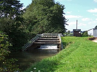
The River Lymn is a river in Lincolnshire, England. It rises in the Wolds on the eastern slope of Castcliffe Hill in Fulletby parish. It flows south-eastwards to the Lincolnshire Marsh, where it becomes known as the Steeping River on the boundary of Great Steeping parish. The main channel is supplemented by the Wainfleet Relief Channel as it passes Wainfleet All Saints, and the relief channel is joined by the old course of the Lymn. Once the two channels rejoin, there are three flood defence structures to protect the region from flooding by the North Sea.

<span class="mw-page-title-main">South Forty-Foot Drain</span> Drainage canal in eastern England

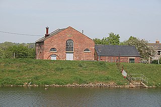
The South Forty-Foot Drain, also known as the Black Sluice Navigation, is the main channel for the land-drainage of the Black Sluice Level in the Lincolnshire Fens. It lies in eastern England between Guthram Gowt and the Black Sluice pumping station on The Haven, at Boston. The Drain has its origins in the 1630s, when the first scheme to make the Fen land available for agriculture was carried out by the Earl of Lindsey, and has been steadily improved since then. Water drained from the land entered The Haven by gravity at certain states of the tide until 1946, when the Black Sluice pumping station was commissioned.

<span class="mw-page-title-main">Bourne Eau</span> River in Lincolnshire, England

Bourne Eau is a short river which rises from an artesian spring in the town of Bourne in Lincolnshire, England, and flows in an easterly direction to join the River Glen at Tongue End. Within the town, it once powered three water mills, one of which is now a heritage centre. At Eastgate, it becomes much wider as it was navigable in the 18th and 19th centuries, and this was the location of the terminal basin. Below the town it is an embanked river, as its normal level is higher than that of the surrounding Fens. Navigation ceased in the 1860s and the river now forms an important part of the drainage system that enables the surrounding fen land to be used for agriculture.

<span class="mw-page-title-main">Internal drainage board</span>

An internal drainage board (IDB) is a type of operating authority which is established in areas of special drainage need in England and Wales with permissive powers to undertake work to secure clean water drainage and water level management within drainage districts. The area of an IDB is not determined by county or metropolitan council boundaries, but by water catchment areas within a given region. IDBs are geographically concentrated in the Broads, Fens in East Anglia and Lincolnshire, Somerset Levels and Yorkshire.

<span class="mw-page-title-main">Witham Navigable Drains</span> United Kingdom legislation

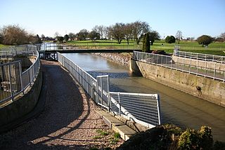
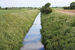
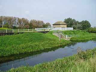
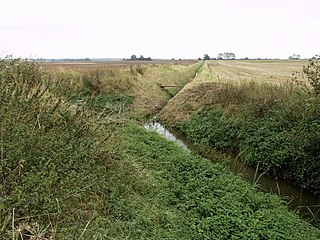
The Witham Navigable Drains are located in Lincolnshire, England, and are part of a much larger drainage system managed by the Witham Fourth District Internal Drainage Board. The Witham Fourth District comprises the East Fen and West Fen, to the north of Boston, which together cover an area of 97 square miles (250 km2). In total there are over 438 miles (705 km) of drainage ditches, of which under 60 miles (97 km) are navigable. Navigation is normally only possible in the summer months, as the drains are maintained at a lower level in winter, and are subject to sudden changes in level as a result of their primary drainage function, which can leave boats stranded. Access to the drains is from the River Witham at Anton's Gowt Lock.

<span class="mw-page-title-main">Witham First District IDB</span> Human settlement in England

Witham First District IDB is an English internal drainage board which was set up under the terms of the Land Drainage Act 1930. The Board inherited the responsibilities of the Witham General Drainage Commissioners, who were first constituted by an Act of Parliament of 1762. They manage the land drainage of an area to the west of the River Witham, between Lincoln and Dogdyke, which includes the valley of the River Slea to above Sleaford.

<span class="mw-page-title-main">River Foulness</span> River in the East Riding of Yorkshire, England

The River Foulness is a river in the East Riding of Yorkshire, England. Its name is derived from Old English fūle[n] ēa, meaning “dirty water”. Maintenance responsibilities for the river transferred from the Environment Agency to the Market Weighton Drainage Board on 1 October 2011. Market Weighton Drainage Board subsequently amalgamated with the Lower Ouse Internal Drainage Board on 1 April 2012 to create the Ouse and Humber Drainage Board. The river discharges into the Humber Estuary via Market Weighton Canal. Water levels within the river, its tributaries and the canal are managed and controlled by the Environment Agency. The river lies in an area known as the Humberhead Levels.

<span class="mw-page-title-main">River Torne (England)</span> River in the north of England

The River Torne is a river in the north of England, which flows through the counties of South Yorkshire and North Lincolnshire. It rises at the Upper Lake at Sandbeck Hall, in Maltby in South Yorkshire, and empties into the River Trent at Keadby pumping station. Much of the channel is engineered, as it plays a significant role in the drainage of Hatfield Chase, which it crosses.

<span class="mw-page-title-main">River Eau</span> River in Lincolnshire, England

The River Eau is a 15-mile-long (24 km) tributary of the River Trent that flows through Lincolnshire, England.

<span class="mw-page-title-main">Witham Third District IDB</span> Human settlement in England

Witham Third District IDB is an English internal drainage board set up under the terms of the Land Drainage Act 1930. The Board inherited the responsibilities of the Witham General Drainage Commissioners, who were first constituted by an Act of Parliament of 1762. They manage the land drainage of an area to the north and east of the River Witham, between Lincoln and Dogdyke, which includes the valley of the River Bain to above Hemingby, and the valleys of Barlings Eau and most of its tributaries, to the north east of Lincoln.

<span class="mw-page-title-main">River Till, Lincolnshire</span> River in Lincolnshire, England

The River Till is a river in the county of Lincolnshire in England and is ultimately a tributary of the River Witham. Its upper reaches drain the land east of Gainsborough. The middle section is embanked, as the water level is higher than that of the surrounding land, and pumping stations pump water from low level drainage ditches into the river. Its lower reaches from the hamlet of Odder near Saxilby into the city of Lincoln were canalised, possibly as early as Roman times, as part of the Foss Dyke.

<span class="mw-page-title-main">Upper Witham IDB</span> Human settlement in England

The Upper Witham IDB is an English Internal Drainage Board responsible for land drainage and the management of flood risk for an area to the west of the Lincolnshire city of Lincoln, broadly following the valleys of the upper River Witham, the River Till and the course of the Fossdyke Navigation.

Welton Beck is a small local stream which originates from Old Man's Head Spring in the west of Welton civil parish and flows eastwards through Welton and Dunholme in the West Lindsey district of Lincolnshire for approximately 10 km (6.2 mi) to a confluence with Barlings Eau near Reasby, which goes on to join the River Witham. The beck is fed from groundwater springs of the Lincolnshire limestone aquifer, with clear freshwater and aquatic plant growth typical of calcareous conditions. The channel of the beck has been largely modified from its original state, having been widened, straightened, and its course significantly altered.

References

  1. 1 2 3 4 Ordnance Survey, 1:50,000 map
  2. Historic England. "Fragment of Barlings Abbey Church (1064017)". National Heritage List for England . Retrieved 5 October 2011.
  3. Historic England. "Fragment of Barlings Abbey (1064016)". National Heritage List for England . Retrieved 5 October 2011.
  4. Alderton 2009, p. 85.
  5. "On-line mapping system". Witham Third District IDB. Archived from the original on 5 August 2012.
  6. "History". Witham Third District IDB. Archived from the original on 24 July 2013.
  7. Hinde 2006 , p. 174
  8. Ordnance Survey, 1:2500 map, 1887
  9. "Stainfield Fen pumping station". Witham Third District IDB. Archived from the original on 25 April 2012.
  10. "Stainfield Fen New pumping station". Witham Third District IDB. Archived from the original on 25 April 2012.
  11. Itinerary 1996, p. 6.
  12. Itinerary 1996, pp. 6–7.
  13. "Glossary (see Biological quality element; Chemical status; and Ecological status)". Catchment Data Explorer. Environment Agency. Retrieved 15 May 2017.
  14. "Barlings Eau – Upper". Catchment Data Explorer. Environment Agency. Retrieved 15 May 2017.
  15. "Faldingworth Beck". Catchment Data Explorer. Environment Agency. Retrieved 15 May 2017.
  16. "Scothern Beck". Catchment Data Explorer. Environment Agency. Retrieved 15 May 2017.
  17. "Legsby (Lissington) Beck". Catchment Data Explorer. Environment Agency. Retrieved 15 May 2017.
  18. "Nettleham Beck". Catchment Data Explorer. Environment Agency. Retrieved 15 May 2017.
  19. "Goltho Beck". Catchment Data Explorer. Environment Agency. Retrieved 15 May 2017.
  20. "Stainfield Beck". Catchment Data Explorer. Environment Agency. Retrieved 15 May 2017.
  21. "Barlings Eau". Catchment Data Explorer. Environment Agency. Retrieved 15 May 2017.

Commons-logo.svg Media related to Barling's Eau at Wikimedia Commons