Caistor | |
---|---|
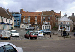
Caistor Market Place | |
Location within Lincolnshire | |
Population | 2,601 (2001) |
OS grid reference | TA1101 |
• London | 135 mi (217 km) S |
Civil parish |
|
District | |
Shire county | |
Region | |
Country | England |
Sovereign state | United Kingdom |
Post town | MARKET RASEN |
Postcode district | LN7 |
Dialling code | 01472 |
Police | Lincolnshire |
Fire | Lincolnshire |
Ambulance | East Midlands |
UK Parliament | |
Caistor is a town and civil parish in the West Lindsey district of Lincolnshire, England. As its name implies, it was originally a Roman castrum or fortress. [1] It lies at the north-west edge of the Lincolnshire Wolds, on the Viking Way, and just off the A46 between Lincoln and Grimsby, at the A46, A1084, A1173 and B1225 junction. It has a population of 2,601. [2] Its name comes from the Anglo-Saxon ceaster ("Roman camp" or "town") and was given in the Domesday Book as Castre. [3]
Only a few fragments of the 4th-century walls remain; for example, the original Roman wall is visible on the southern boundary of the parish church of St Peter and St Paul. [1] The area occupied by the fortress is now classified as a Scheduled Ancient Monument. [1] The church of St Peter and St Paul, which is enclosed within the fortress, has an Anglo-Saxon tower. [4] The market square lies at the heart of a conservation area which contains 56, mainly Grade II, listed buildings. In numerical terms, the number of listed buildings makes Caistor the most important conservation area in the West Lindsey area; many of the buildings are Georgian or Victorian. Notable buildings in the town include Caistor Grammar School, founded in 1633, [5] and Sessions House, built in 1662.
In 2010 the remains of a 4th-century Roman cemetery were found during the development of a new Co-op supermarket. [6] [7] [8]
Caistor Grammar School dates from the reign of Charles I. An academy with a selective pupil intake, it has specialist school status for sports and humanities.[ citation needed ] Sir Henry Newbolt, author of Drake's Drum , was educated at the school. [9] [10]
Caistor Yarborough Academy is a mixed comprehensive school named in memory of John Edward Pelham, the 7th Earl of Yarborough. Being limited to 570 pupils it is much smaller than the average British school of this type. It has Arts College status under the English specialist schools programme.[ citation needed ] In 2012 the school became an Academy.
Opened in 1940, RAF Caistor was built as a relief airfield for RAF Kirton in Lindsey, and also used for flying training from its grass runways. Closed in 1945, it later reopened as a nuclear missile base.
Between 1959 and 1963 Caistor was manned by 269(SM) Sqn. equipped with three Thor missiles. The site has now returned to agricultural use, and little remains of the military facilities. [11] [12]
The nearest railway station is Barnetby railway station. The town was formerly served by the stations at both North Kelsey and Moortown. Both are now closed but the station buildings survive as private residences.
The town has bus services to Brigg, Grimsby, Market Rasen and Lincoln. Operated by Stagecoach.
Humberside Airport is also located a short distance to the north of the town.
Audleby is a hamlet just north of Fonaby. It is recorded in the Domesday Book with 33 households, which at the time constituted a significant settlement. Today it is listed as a deserted medieval village (DMV). [13] Audleby House on Brigg Road is a Grade II listed building. [14]
Fonaby is a hamlet and deserted medieval village just north of Caistor, mentioned in the Domesday Book as having 18 households and three acres of meadow, and held by William I. [15] [16]
According to a local tradition, one of Jesus's 12 apostles, Simon the Zealot, came to England, where he is supposed to have been martyred somewhere in the vicinity of Caistor. He was reputedly crucified on the orders of a Roman procurator called Catus Decianus on 10 May AD61. (However, there are competing theories as to what became of Simon the Zealot.) [18]
Asterby is a hamlet between Goulceby and Scamblesby, west of Louth, in the East Lindsey district of Lincolnshire, England. The civil parish of Asterby had a population of 103 according to the 2001 census, increasing to 159 at the 2011 census.
Kirmington is a village in North Lincolnshire, England. It is part of the civil parish of Kirmington and Croxton. From the 2011 census the village became a civil parish in its own name. Kirmington is situated just north from the A18 road, 5 miles (8 km) west from Immingham and 7 miles (11 km) east from Brigg. Less than 1 mile (1.6 km) to the west is Humberside International Airport, the former Second World War station, RAF Kirmington.
Bigby is a village and civil parish in the West Lindsey district of Lincolnshire, England.
Bottesford is a town in North Lincolnshire, Lincolnshire, England.
Scawby is a village and civil parish in North Lincolnshire, England. It is situated 2 miles (3 km) south-west from Brigg, and just east from the A15 road, and south from the M180 motorway. According to the 2001 Census, Scawby population was 2,277, reducing slightly to 2,243 at the 2011 census.
Cabourne is a hamlet and civil parish in the West Lindsey district of Lincolnshire, England. It is situated on the A46 road, and just over 1 mile (1.6 km) east from the town of Caistor. It is in the civil parish of Swallow.
Grainthorpe is a small village and civil parish in the East Lindsey district of Lincolnshire, England. It is situated 7 miles (11 km) north-east from the town of Louth, and approximately 3 miles (5 km) from the Lincolnshire coast. The civil parish includes the hamlets of Wragholme to the north-west, and Ludney to the south-east. The population of Conisholme is included in the 2011 census.
Searby is a village in the West Lindsey district of Lincolnshire, England, situated 4 miles (6.4 km) south-east from Brigg and 5 miles (8.0 km) north-east from Caistor. The village is in the civil parish of Searby cum Owmby, between the villages of Somerby and Grasby, and in the Lincolnshire Wolds, a designated Area of Outstanding Natural Beauty. Less than 1 mile (1.6 km) to the south is the parish hamlet of Owmby.
Croxby is a hamlet and former civil parish in the West Lindsey district of Lincolnshire, England. It is situated approximately 5 miles (8.0 km) east from the town of Caistor.
East Barkwith is a village and civil parish in the East Lindsey district of Lincolnshire, England. It is situated on the A157, and approximately 13 miles (21 km) north-east from the city and county town of Lincoln,
Fulnetby is a hamlet and civil parish in the West Lindsey district of Lincolnshire, England. It is situated approximately 8 miles (13 km) north-east from the city and county town of Lincoln.
Knaith is a village and civil parish about 3 miles (5 km) south of the town of Gainsborough in the West Lindsey district of Lincolnshire, England. The population of the civil parish at the 2011 census was 335.
Market Stainton is a village and civil parish in the East Lindsey district of Lincolnshire, England. It is situated approximately 7 miles (11 km) north from the market town of Horncastle.
Middle Rasen is a village and civil parish in the West Lindsey district of Lincolnshire, England, located about 1.5 miles (2.4 km) west from the town of Market Rasen. The population of the civil parish at the 2011 census was 2,043.
Newton on Trent is a village and civil parish in the West Lindsey district of Lincolnshire, England. The population of the civil parish at the 2011 census was 389. The village is situated east of the River Trent, and approximately 10 miles (16 km) south from Gainsborough, 10 miles (16 km) west from the county town of Lincoln, and at the junction of the A57 running east to west, and the A1133 running north to south.
Snelland is a village and civil parish in the West Lindsey district of Lincolnshire, England. It is situated approximately 9 miles (14 km) north-east from the city and county town of Lincoln and about 5 miles (8 km) from the town of Market Rasen. The civil parish includes the hamlet of Swinthorpe. The population at the 2011 census was included in the civil parish of Friesthorpe.
Northorpe is a village and civil parish in the West Lindsey district of Lincolnshire, England, about 8 miles (13 km) north-east from the town of Gainsborough. The population of the civil parish at the 2011 census was 126.
Stenigot is a village in the East Lindsey district of Lincolnshire, England. It is in the Lincolnshire Wolds, a designated Area of Outstanding Natural Beauty, about 6 miles (9.7 km) south-west from the town of Louth, and 1 mile (1.6 km) south-east from the village of Donington on Bain. It includes the hamlet of Cold Harbour. The population is included in the civil parish of Asterby.
Owmby is a hamlet in the civil parish of Searby cum Owmby, in the West Lindsey district of Lincolnshire, England. It is less than 1 mile (1.6 km) south from the A1084 road, 3 miles (5 km) north-west from Caistor, 4 miles (6 km) south-east from Brigg, and in the Lincolnshire Wolds, a designated Area of Outstanding Natural Beauty. The parish village of Searby is less than 1 mile to the north-east.
Thornton le Moor is a village in the civil parish of Owersby in the West Lindsey district of Lincolnshire, England, situated approximately 5 miles (8 km) south-west from the town of Caistor. Between 1866 and 1936 Thornton le Moor was a separate civil parish.