
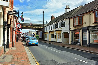
North Thoresby is a village and civil parish in the East Lindsey district of Lincolnshire, England. It is situated between Louth and Grimsby, approximately 7.5 miles (12 km) from each. and has a village population of 1,068 (2011) Some 50.5% of the population is older than 60 years.

West Lindsey is a local government district in Lincolnshire, England. Its council is based in Gainsborough, the district's largest town. The district also includes the towns of Caistor and Market Rasen, along with numerous villages and surrounding rural areas. The east of the district includes part of the Lincolnshire Wolds, a designated Area of Outstanding Natural Beauty.
Market Rasen is a market town and civil parish within the West Lindsey district of Lincolnshire, England. The River Rase runs through it east to west, approximately 13 miles (21 km) north-east from Lincoln, 18 miles (29 km) east from Gainsborough, 14 miles (23 km) west of Louth, and 16 miles (26 km) south-west from Grimsby. It lies on the main road between Lincoln and Grimsby, the A46, and is famous for its racecourse. In 2001, the town had a population of 3,200. In the 2011 census, the population of the civil parish was 3,904.

Caistor is a town and civil parish in the West Lindsey district of Lincolnshire, England. As its name implies, it was originally a Roman castrum or fortress. It lies at the north-west edge of the Lincolnshire Wolds, on the Viking Way, and just off the A46 between Lincoln and Grimsby, at the A46, A1084, A1173 and B1225 junction. It has a population of 2,601. Its name comes from the Anglo-Saxon ceaster and was given in the Domesday Book as Castre.

Saxilby is a village and civil parish in the West Lindsey district of Lincolnshire, England, about 6 miles (9.7 km) north-west from Lincoln, on the A57 road at the junction of the B1241. It is part of the civil parish of Saxilby and Ingleby, which includes the village of Ingleby. The population of the civil parish in 2001 was 3,679, increasing to 3,992 at the 2011 census.

Blyton is a village and civil parish within the West Lindsey district of Lincolnshire, England. It is situated approximately 4 miles (6 km) north-east from Gainsborough. From Blyton the village of Laughton lies to the north, and Pilham to the south-east, while the course of the River Trent runs nearby to the west.
Cherry Willingham is a large village and civil parish in the West Lindsey district of Lincolnshire, England. The population at the 2011 census was 3,506. It is situated approximately 4 miles (6 km) east from the city and county town of Lincoln. Neighbouring villages are Reepham, Nettleham and Fiskerton.

Hackthorn is a village and civil parish in the West Lindsey district of Lincolnshire, England. It is combined with Cold Hanworth to form the parish council of Hackthorn and Cold Hanworth. The population of the civil parish at the 2011 census was 207. It is situated approximately 6 miles (10 km) north from the city and county town of Lincoln, and 1 mile (1.6 km) east from the A15. According to the 2001 Census it had a population of 180. The village is part of the Owmby Group of parishes.

Owmby-by-Spital is a village and civil parish in the West Lindsey district of Lincolnshire, England. It is situated 2 miles (3 km) east from the A15 road, 11 miles (18 km) north from Lincoln and 8 miles (13 km) west from Market Rasen. The population of the civil parish was 388 at the 2011 census. The village is part of the Owmby Group of parishes.

South Kelsey is a village and civil parish in the West Lindsey district of Lincolnshire, England. It is situated on the B1205, 5 miles (8.0 km) east from the A15 and 4.5 miles (7 km) south-west from Caistor.
North Kelsey is a village and civil parish in the West Lindsey district of Lincolnshire, England. The village is situated 4 miles (6 km) west from Caistor and 19 miles (31 km) north-east from the county town of Lincoln.

Moortown is a hamlet in the civil parish of South Kelsey, and in the West Lindsey district of Lincolnshire, England. It is at the crossroads of the B1205 and B1434 roads, 3 miles (5 km) south-west from Caistor, 7 miles (11 km) south-east from Brigg and 14 miles (23 km) west from Grimsby. The population is included in the civil parish of South Kelsey.

Thoresway is a village and civil parish in the West Lindsey district of Lincolnshire, England. It is 1.5 miles (2.4 km) west from the B1225 road, 4 miles (6.4 km) southeast from Caistor and 6 miles (10 km) north-east from Market Rasen. The population was 198 at the 2011 census.

Grasby is a small village and civil parish in the West Lindsey district of Lincolnshire, England. The population of the civil parish taken at the 2011 census was 480. It is situated 3 miles (5 km) north-west of the town of Caistor and lies in the Lincolnshire Wolds, a designated Area of Outstanding Natural Beauty.

Rothwell is a small village and civil parish in the district of West Lindsey in north-east Lincolnshire, England. The population of the civil parish at the 2011 census was 226. The village is situated approximately 2.5 miles (4.0 km) south-east from Caistor and 9 miles (14 km) north from Market Rasen. It is 2 miles (3.2 km) east of the Viking Way. The parish covers just over 2,870 acres (11.6 km2) and is primarily agricultural land.

Cuxwold is a village and former civil parish, now in the parish of Swallow, in the West Lindsey district of Lincolnshire, England. It lies in the Lincolnshire Wolds, 4 miles (6 km) east from Caistor and 10 miles (16 km) south-west from Grimsby. In 1931 the parish had a population of 98. On 1 April 1936 the parish was abolished and merged with Swallow.

Holton le Moor is a small village and civil parish in the West Lindsey district of Lincolnshire, England.

Clixby is a small village and former civil parish, now in the parish of Grasby, in the West Lindsey district of Lincolnshire, England. It is situated approximately 2 miles (3 km) north from the town of Caistor, and lies in the Lincolnshire Wolds, a designated Area of Outstanding Natural Beauty. In 1931 the parish had a population of 39.

Middle Rasen is a village and civil parish in the West Lindsey district of Lincolnshire, England, located about 1.5 miles (2.4 km) west from the town of Market Rasen. The population of the civil parish at the 2011 census was 2,043.

Stainton le Vale is a village in the civil parish of Thoresway in the West Lindsey district of Lincolnshire, England. It is situated about 6 miles (9.7 km) north-east from the town of Market Rasen and about 6 miles south-east from the town of Caistor. It is a former civil parish and lies in the Lincolnshire Wolds, a designated Area of Outstanding Natural Beauty.

