
National nature reserves in England are designated by Natural England as key places for wildlife and natural features in England. They were established to protect the most significant areas of habitat and of geological formations. NNRs are managed on behalf of the nation, many by Natural England itself, but also by non-governmental organisations, including the members of The Wildlife Trusts partnership, the National Trust, and the Royal Society for the Protection of Birds.

The Studland and Godlingston Heaths NNR is located on the Isle of Purbeck in the English county of Dorset. It borders Studland Bay on the south side of Poole Harbour, between the settlements of Swanage and Sandbanks. Extending to 631ha, it is owned and managed by the National Trust following the Bankes bequest of the Kingston Lacy estate. Studland & Godlingston Heath is designated as one of only 35 "spotlight reserves" in England by Natural England in the list of national nature reserves in England and is listed as a Site of Special Scientific Interest (SSSI).

Saltfleet is a coastal village in the East Lindsey district of Lincolnshire, England. It is approximately 8 miles (13 km) north of Mablethorpe and 11 miles (18 km) east of Louth.

The Lincolnshire Wildlife Trust,, covers the whole ceremonial county of Lincolnshire, England. It was founded in 1948 as a voluntary charitable organisation dedicated to conserving the wildlife and wild places of Lincolnshire and to promoting the understanding and enjoyment of the natural world.

Loch Fleet is a sea loch on the east coast of Scotland, located between Golspie and Dornoch. It forms the estuary of the River Fleet, a small spate river that rises in the hills east of Lairg. The loch was designated a National Nature Reserve (NNR) in 1998, and is managed by a partnership between NatureScot, the Scottish Wildlife Trust (SWT) and Sutherland Estates. The NNR extends to 1058 hectares, including the Loch Fleet tidal basin, sand dunes, shingle ridges and the adjacent pine woods, including Balbair Wood and Ferry Wood. The tidal basin of the loch covers over 630 ha, and forms the largest habitat on the NNR.

Gibraltar Point national nature reserve is an area of about 4.3 km2 (1.7 sq mi) on the coast of Lincolnshire, England.

Saltfleetby is a village and civil parish in the East Lindsey district of Lincolnshire, England on the coast of the North Sea, approximately 7 miles (11 km) east from Louth and 10 miles (16 km) north from Mablethorpe. The parish had a population of 599 in the 2001 Census, decreasing to 568 at the 2011 Census.

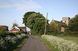
Theddlethorpe St Helen or East Theddlethorpe is a village and civil parish in the East Lindsey district of the county of Lincolnshire, England. It lies about 3 miles (5 km) north of Mablethorpe on the North Sea coast. Some seashore belongs to Saltfleetby-Theddlethorpe Dunes National Nature Reserve, consisting of sea dunes and saltwater and freshwater marshes. It is one of five UK locations where the natterjack toad is found. In 2011 the parish had a population of 525. The parish touches Gayton le Marsh, Mablethorpe and Sutton, Theddlethorpe All Saints and Withern with Stain. Theddlethorpe St Helen shares a parish council with Theddlethorpe All Saints.
North Somercotes is a village near to the North Sea coast, in the district of East Lindsey and the Marshes area, of Lincolnshire, England. The village is situated midway between the towns of Mablethorpe and Cleethorpes.
Blakeney Point is a national nature reserve situated near to the villages of Blakeney, Morston and Cley next the Sea on the north coast of Norfolk, England. Its main feature is a 6.4 km (4.0 mi) spit of shingle and sand dunes, but the reserve also includes salt marshes, tidal mudflats and reclaimed farmland. It has been managed by the National Trust since 1912, and lies within the North Norfolk Coast Site of Special Scientific Interest, which is additionally protected through Natura 2000, Special Protection Area (SPA), International Union for Conservation of Nature (IUCN) and Ramsar listings. The reserve is part of both an Area of Outstanding Natural Beauty (AONB), and a World Biosphere Reserve. The Point has been studied for more than a century, following pioneering ecological studies by botanist Francis Wall Oliver and a bird ringing programme initiated by ornithologist Emma Turner.

The coast of Lincolnshire runs for more than 50 miles (80 km) down the North Sea coast of eastern England, from the estuary of the Humber to the marshlands of the Wash, where it meets Norfolk. This stretch of coastline has long been associated with tourism, fishing and trade.

Staple Island is a small rocky island, or skerry, that is one of the Outer Group of the Farne Islands in Northumberland, England. The Farne Islands are a designated National Nature Reserve. Staple Island is an important wildlife habitat known for its prolific breeding colonies of Atlantic puffins, razorbills and kittiwakes. A notable colony of grey seals breeds on the island with pups born every year in September–November.
Saltfleetby-Theddlethorpe Dunes is a national nature reserve on the coast of Lincolnshire, England, in the parishes of Saltfleetby and Theddlethorpe. It is managed in part by Natural England; in part by the Lincolnshire Wildlife Trust, and consists of 1,377 acres (557 ha) of sand dunes, salt marsh, sand and mudflats. It is on Rimac Road and sometimes referred to as Rimac.

The A1031 is a major secondary route in Lincolnshire that runs most of the North East coast of the county. It is 24.75 miles (39.8 km). It runs from Cleethorpes at Love Lane Corner Roundabout with the A46 road and ends at the A1104 road at Mablethorpe.

Donna Nook Air Weapons Range is a Ministry of Defence air weapons range in East Lindsey, Lincolnshire, England. The range, as well as a now defunct airfield and radar station, were previously operated by the Royal Air Force and known as RAF Donna Nook.

The North Norfolk Coast Site of Special Scientific Interest (SSSI) is an area of European importance for wildlife in Norfolk, England. It comprises 7,700 ha (19,027 acres) of the county's north coast from just west of Holme-next-the-Sea to Kelling, and is additionally protected through Natura 2000, Special Protection Area (SPA) listings; it is also part of the Norfolk Coast Area of Outstanding Natural Beauty (AONB). The North Norfolk Coast is also designated as a wetland of international importance on the Ramsar list and most of it is a Biosphere Reserve.

Lindisfarne National Nature Reserve is a 3,541-hectare (8,750-acre) UK national nature reserve. It was founded to help safeguard the internationally important wintering bird populations, and six internationally important species of wildfowl and wading birds winter here. For the pale-bellied brent geese from Svalbard, this is their only regular wintering place in all of the United Kingdom. Pinkfooted and greylag geese, wigeons, grey plovers and bar-tailed godwits are the other visitors.

The Mablethorpe Seal Sanctuary and Wildlife Centre, often abbreviated to Mablethorpe Seal Sanctuary or Mablethorpe Wildlife Centre is a seal sanctuary and animal attraction in the coastal town of Mablethorpe, Lincolnshire, England. It is a tourist attraction and works to rehabilitate sick and injured seals. It is located close to the seal breeding colony at Donna Nook and many of the animals it rescues are young seals born there.
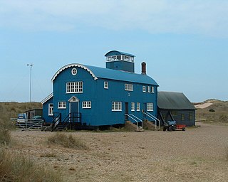
Donna Nook Lifeboat Station was located north of the village of North Somercotes, in the East Lindsey district of the county of Lincolnshire.


