The East Riding of Yorkshire, often shortened to the East Riding and alternatively known as East Yorkshire, is a ceremonial county in the Yorkshire and the Humber region of England. It borders North Yorkshire to the north and west, South Yorkshire to the south-west, and Lincolnshire to the south across the Humber Estuary. The city of Kingston upon Hull is the largest settlement.

The Yorkshire Wolds are hills in the counties of the East Riding of Yorkshire and North Yorkshire in Northern England. They are the northernmost chalk hills in the UK and within lies the northernmost chalk stream in Europe, the Gypsey Race.

The Weald is an area of South East England between the parallel chalk escarpments of the North and the South Downs. It crosses the counties of Hampshire, Surrey, West Sussex, East Sussex, and Kent. It has three separate parts: the sandstone "High Weald" in the centre; the clay "Low Weald" periphery; and the Greensand Ridge, which stretches around the north and west of the Weald and includes its highest points. The Weald once was covered with forest, and its name, Old English in origin, signifies "woodland". The term is still used today, as scattered farms and villages sometimes refer to the Weald in their names.

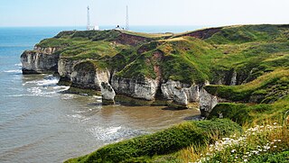
Alkborough is a parish of 471 people in 192 households in North Lincolnshire, England, located near the northern end of The Cliff range of hills overlooking Trent Falls, the confluence of the River Trent and the River Ouse.

The Lincolnshire Wolds are a range of low hills in the county of Lincolnshire, England which run roughly parallel with the North Sea coast, from the Humber Estuary in the north-west to the edge of the Lincolnshire Fens in the south-east. A large part of the Wolds are a designated Area of Outstanding Natural Beauty (AONB), and form the highest land in eastern England between Yorkshire and Kent.
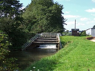
The River Lymn is a river in Lincolnshire, England. It rises in the Wolds on the eastern slope of Castcliffe Hill in Fulletby parish. It flows south-eastwards to the Lincolnshire Marsh, where it becomes known as the Steeping River on the boundary of Great Steeping parish. The main channel is supplemented by the Wainfleet Relief Channel as it passes Wainfleet All Saints, and the relief channel is joined by the old course of the Lymn. Once the two channels rejoin, there are three flood defence structures to protect the region from flooding by the North Sea.
The ceremonial county of Lincolnshire is the second largest of the English counties and one that is predominantly agricultural in character. Despite its relatively large physical area, it has a comparatively small population. The unusually low population density that arises gives the county a very different character from the much more densely populated an urbanised counties of south-east and northern England, and is, in many ways, key to understanding the nature of the county.

The Wolds is a term used in England to describe a range of hills which consists of open country overlying a base of limestone or chalk.

Chalk streams are rivers that rise from springs in landscapes with chalk bedrock. Since chalk is permeable, water percolates easily through the ground to the water table and chalk streams therefore receive little surface runoff. As a result, the water in the streams contains little organic matter and sediment and is generally very clear.

Firsby is a small rural linear village and civil parish in the East Lindsey district of Lincolnshire, England. It is situated 30 miles (48 km) east from the city and county town of Lincoln, 4 miles (6.4 km) south-east from the nearest market town of Spilsby, and 7 miles (11 km) inland from the holiday resort town of Skegness.

Calceby is a small village and former civil parish, now in the parish of South Thoresby, in the East Lindsey district of Lincolnshire, England. It is situated approximately 4 miles (6 km) west from the market town of Alford. In 1961 the parish had a population of 32. On 1 April 1987 the parish was abolished and merged with South Thoresby. Once much larger, Calceby is recorded in the Domesday Book as "Calesbi". Lord of the Manor in 1086 was Earl Hugh of Chester. By the early seventeenth century, the conversion of agriculture from corn to pasture had begun a process of depopulation of the parish.
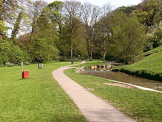
Hubbard's Hills is an area of natural beauty directly to the west of Louth, Lincolnshire, England and is popular for family picnics, school field trips and dog walking. The park is dedicated to the memory of Annie Pahud.

The Gypsey Race is a winterbourne stream that rises to the east of Wharram-le-Street and flows through the villages of Duggleby, Kirby Grindalythe, West Lutton, East Lutton, Helperthorpe, Weaverthorpe, Butterwick, Foxholes, Wold Newton, Burton Fleming, Rudston and Boynton. The stream flows into the North Sea in Bridlington harbour. It is the most northerly of the Yorkshire chalk streams.

South Willingham is a village and civil parish in the East Lindsey district of Lincolnshire, England, and partly within the Lincolnshire Wolds Area of Outstanding Natural Beauty,. It is situated 1 mile (2 km) south of the A157 Lincoln to Louth road, 15 miles (24 km) west of Lincoln, where the central Lincolnshire Vale and the Lincolnshire Wolds meet. Its population was 160 at the 2011 census, down from a maximum of 341 in 1851.
Greetham with Somersby is a civil parish in the East Lindsey district of Lincolnshire, England. It is situated approximately 3 miles (5 km) north-east from the market town of Horncastle.

Covenham Reservoir, located in East Lindsey is a 200-acre reservoir and treatment works constructed between 1963 and 1978 by W. & C. French. The reservoir was built next to the Louth Navigation canal and acts as a pumped storage reservoir from the canal, and can be supplemented by transfer schemes from Great Eau and Long Eau rivers.

The Long Eau is a river in Lincolnshire, England, rising from the Chalk Streams of the Lincolnshire Wolds and joining its companion stream, the Great Eau south of Saltfleetby All Saints.
The south bank of the Humber Estuary in England is a relatively unpopulated area containing large scale industrial development built from the 1950s onward, including national scale petroleum and chemical plants as well as gigawatt scale gas fired power stations.
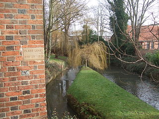
The 1920 Louth flood was a severe flash flooding event in the Lincolnshire market town of Louth which occurred 29 May 1920, resulting in 23 fatalities in 20 minutes. It has been described as one of the most significant flood disasters in Britain and Ireland during the 20th century.


