The River Nene is a river in the east of England that rises from three sources in Northamptonshire. The river is about 100 miles (160 km) long, about 3.7 miles (6.0 km) of which forms the border between Cambridgeshire and Norfolk. It is the tenth-longest river in the United Kingdom, and is navigable for 88 miles (142 km), from Northampton to The Wash.

The Aller is a 215-kilometre-long (134 mi) river in the states of Saxony-Anhalt and Lower Saxony in Germany. It is a right-hand, and hence eastern, tributary of the Weser and is also its largest tributary. Its last 117 kilometres (73 mi) form the Lower Aller federal waterway (Bundeswasserstraße). The Aller was extensively straightened, widened and, in places, dyked, during the 1960s to provide flood control of the river. In a 20-kilometre-long (12 mi) section near Gifhorn, the river meanders in its natural river bed.

The Foss Dyke, or Fossdyke, connects the River Trent at Torksey to Lincoln, the county town of Lincolnshire, and may be the oldest canal in England that is still in use. It is usually thought to have been built around AD 120 by the Romans, but there is no consensus among authors. It was refurbished in 1121, during the reign of King Henry I, and responsibility for its maintenance was transferred to the city of Lincoln by King James I. Improvements made in 1671 included a navigable sluice or lock at Torksey, and warehousing and wharves were built at Brayford Pool in the centre of Lincoln.

Horncastle is a town and civil parish in Lincolnshire, 17 miles (27 km) east of Lincoln. Its population was 6,815 at the 2011 census, and was estimated to be 7,123 in 2019. A section of the ancient Roman walls remains.

The River Ivel is a north-flowing river in the western part of east of England. It is primarily in Bedfordshire; it is a tributary of the River Great Ouse and has sources including in the Barton Hills.

The Huai River, formerly romanized as the Hwai, is a major river in China. It is located about midway between the Yellow River and Yangtze, the two longest rivers and largest drainage basins in China, and like them runs from west to east. Historically draining directly into the Yellow Sea, floods have changed the course of the river such that it now primarily dischages into the Yangtze. The Huai is notoriously vulnerable to flooding.

The River Bain is a river in Lincolnshire, England, and a tributary of the River Witham.

Coningsby is a village and civil parish in the East Lindsey district in Lincolnshire, England, it is situated on the A153 road, adjoining Tattershall on its western side, 13 miles (22 km) north west of Boston and 8 miles (13 km) south west from Horncastle.

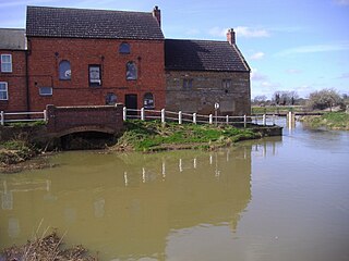
The Horncastle Canal was a broad canal which ran 11 miles from the River Witham to Horncastle in Lincolnshire, England, through twelve locks largely following the course of River Bain. The canal opened in 1802, and was abandoned for navigation in 1889.

Donington on Bain is a village and civil parish in the East Lindsey district of Lincolnshire, England.
Lincolnshire is a large county in England with a sparse population distribution, which leads to problems funding all sorts of transport. The transport history is long and varied, with much of the road network still based on the Roman model, and the once extensive rail network a shadow of its former self.

The River Cart is a tributary of the River Clyde, Scotland, which it joins from the west roughly midway between the towns of Erskine and Renfrew and opposite the town of Clydebank.
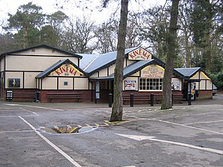
Woodhall Spa is a former spa town and civil parish in Lincolnshire, England, on the southern edge of the Lincolnshire Wolds, 6 miles (10 km) south-west of Horncastle, 23 miles (37 km) west of Skegness, 15 miles (24 km) east-south-east of Lincoln and 17 miles (27 km) north-west of Boston. It is noted for its mineral springs, cinema and its Second World War association with the RAF 617 Squadron. The cinema has the last remaining rear screen projector in the country.

Cagthorpe is suburb of the town of Horncastle, Lincolnshire, England. It is south of, and separated from, the historic town centre by the re-aligned River Waring and the A158.

The Douglas Navigation was a canalised section of the River Douglas or Asland, in Lancashire, England, running from its confluence with the River Ribble to Wigan. It was authorised in 1720, and some work was carried out, but the undertakers lost most of the share money speculating on the South Sea Bubble. Alexander Leigh attempted to revive it eleven years later, and opened it progressively between 1738 and 1742. Leigh began work on a parallel canal called Leigh's Cut to improve the passage from Newburgh to Gathurst, but progress was slow and it was unfinished in 1771.

Dogdyke railway station was a station on the former Great Northern Railway between Boston and Lincoln.

Kirkby on Bain is a village and civil parish in the East Lindsey district of Lincolnshire, England. It lies on the River Bain between Horncastle and Coningsby, and just west of the A153 road. Close to the north is the village of Haltham.

The A153 is a non-primary A road entirely in Lincolnshire in the east of England.
Kirkstead is an ancient village and former parish on the River Witham in Lincolnshire, England. It was amalgamated with the civil parish of Woodhall Spa in 1987.

Woodhall Spa railway station was a station in Woodhall Spa, Lincolnshire on a small branch line running north from Woodhall Junction to Horncastle. Both the station and the line are now closed.

