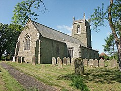
Sausthorpe is a small village and civil parish in the East Lindsey district of Lincolnshire, England, 8 miles (13 km) east of Horncastle and 3 miles (4.8 km) north-west of Spilsby. It lies on the southern edge of the Lincolnshire Wolds – a designated Area of Outstanding Natural Beauty – in the valley of the River Lymn. Farming remains the dominant economic activity in the area. The population was 305 in the 2011 census and estimated at 306 in 2019.

Breedon on the Hill is a village and civil parish about 5 miles (8 km) north of Ashby-de-la-Zouch in North West Leicestershire, England. The parish adjoins the Derbyshire county boundary and the village is only about 2 miles (3 km) south of the Derbyshire town of Melbourne. The 2001 Census recorded a parish population of 958 people in 404 households. The parish includes the hamlets of Tonge 1 mile (1.6 km) east of the village and Wilson 1.3 miles (2 km) north of the village on the county boundary. The population at the 2011 census was 1,029 in 450 households.

Horncastle is a market town and civil parish in the East Lindsey district in Lincolnshire, England. It is 17 miles (27 km) east of Lincoln. Its population was 6,815 at the 2011 census and estimated at 7,123 in 2019. A section of the ancient Roman walls remains.
Cold Ashby is a village and civil parish in West Northamptonshire in England. At the time of the 2001 census, the parish's population was 255 people, increasing to 278 at the 2011 census.

Ashby Puerorum is a small village and former civil parish, now in the parish of Greetham with Somersby, in the East Lindsey district of Lincolnshire, England. The village situated 6 miles (10 km) north-west from Partney, 4 miles (6 km) east from Horncastle, to the north of the A158 road, and to the west of Bag Enderby. In 1931 the parish had a population of 97. On 1 April 1936 the parish was abolished and merged with Somersby.

Tixover is a small village and civil parish in Rutland. The population of the civil parish at the 2001 census was 174, falling to 163 at the 2011 census.

Ibstock is a former coal mining town and civil parish about 3 miles (5 km) south of Coalville in North West Leicestershire, England. The population of the civil parish was 5,760 at the 2001 census increasing to 6,201 at the 2011 census and 7,615 at the 2021 census.

Belchford is a village and civil parish in the East Lindsey district of Lincolnshire, England. The village is situated approximately 4 miles (6 km) north of Horncastle and just to the east of the A153. At the 2011 Census, the population of the parish was 255.

Barton is a village and civil parish in the unitary authority of Cheshire West and Chester and the ceremonial county of Cheshire, England. The village is located near the Welsh border, about twelve miles south of Chester and only about eight miles east of Wrexham in Wales.

Baumber is a village and civil parish in the East Lindsey district of Lincolnshire, England. It is situated approximately 4 miles (6 km) north-west from Horncastle, and at the junction of the B1225 and the A158 roads.

Wramplingham is a village and civil parish in the English county of Norfolk. It is situated on the River Tiffey some 4 miles (6.4 km) north of Wymondham and 7 miles (11 km) west of Norwich. The civil parish has an area of 3.47 square kilometres and in 2001 had a population of 110 in 44 households, increasing to a population of 115 in 51 households at the 2011 Census. For the purposes of local government, the parish falls within the district of South Norfolk.

Worthington is a village and civil parish in North West Leicestershire, England, about 4 miles (6.4 km) north of the town of Coalville and a similar distance north-east of the market town of Ashby-de-la-Zouch. The population of the civil parish at the 2011 census was 1,461. The village is about 5 miles (8 km) from East Midlands Airport and junction 23a of the M1 motorway where it meets the A42 road. The parish also includes the hamlet of Newbold.

Hemingby is a dispersed village and civil parish in the East Lindsey district of Lincolnshire, England. It is situated approximately 3 miles (5 km) north from the market town of Horncastle and just west from the junction of the B1225 and A158 roads. It is surrounded by the villages of Baumber, Goulceby and West Ashby. The River Bain and its tributary, the Hemingby Beck, flow through the village.

Thornham is a village and civil parish in the English county of Norfolk. It is situated on the north Norfolk coast some 7 kilometres (4.3 mi) north-east of the seaside resort of Hunstanton, 30 km (19 mi) north of the town of King's Lynn and 70 km (43 mi) north-west of the city of Norwich.

West Deeping is a village and civil parish in the South Kesteven district of Lincolnshire, England. The population of the civil parish at the 2011 census was 255. It is situated on the A1175 road, 5 miles (8 km) east from Stamford and 2 miles (3.2 km) west from Market Deeping. It is the smallest of The Deepings group of villages situated around the A1175 road. Village population is 277.

Pudding Norton is a village and civil parish in the English county of Norfolk. It covers an area of 2.30 sq mi (6.0 km2) and had a population of 267 in 126 households at the 2001 census, falling to 252 at the 2011 Census. For the purposes of local government, it falls within the district of North Norfolk.

Tetford is a village and civil parish in the East Lindsey district of Lincolnshire, England.

Coleorton is a village and civil parish in North West Leicestershire, England. It is situated on the A512 road approximately 2 miles (3.2 km) east of Ashby de la Zouch. Nearby villages include Newbold, to the north, Thringstone to the east, and Swannington to the south-east.
Edlington with Wispington is a civil parish in the East Lindsey district of Lincolnshire, England. It is approximately 2 miles (3 km) north-west of Horncastle town centre. It contains the hamlets of Edlington and Wispington.
Greetham with Somersby is a civil parish in the East Lindsey district of Lincolnshire, England. It is situated approximately 3 miles (5 km) north-east from the market town of Horncastle.