
Lingfield is a village and civil parish in the Tandridge district of Surrey, England, approximately 23 miles (37 km) south of London. Several buildings date from the Tudor period and the timber-frame medieval church is Grade I listed. The stone cage or old gaol, constructed in 1773, was last used in 1882 to hold a poacher.

Nocton is a village and civil parish in the North Kesteven district of Lincolnshire, England. It is situated on the B1202 road, 7 miles (11 km) south-east from Lincoln city centre. The population of the civil parish at the 2011 census was 819. To the east of the village is Nocton Fen with its small settlement of Wasps Nest. To the west of the village, situated at the junction of Wellhead Lane and the B1188 road, is Nocton Top Cottages consisting of eight further dwellings. At the south of the village are the remains of Nocton Hall, and 1 mile (2 km) to the east the earthwork remains of Nocton Park Priory.
Dowsby is a village and civil parish in the South Kesteven district of Lincolnshire, England. It is situated on the western edge of The Fens at the junction of the east–west B1397 road and the north–south B1177. It is 1 mile (1.6 km) north-east from Rippingale and just south of Pointon. The civil parish includes the hamlet of Graby. Nearby to the east, along the B1397 at Dowsby Fen, is Car Dyke. The civil parish population taken at the 2011 census was 204.

East Ravendale is a small village and civil parish in North East Lincolnshire, England. It is situated 6 miles (9.7 km) south-south-west from Grimsby, and 0.5 miles (0.8 km) west from the A18.

Thornton-le-Dale is a village and civil parish in the Ryedale district of North Yorkshire, England, about 3 miles (5 km) east of Pickering on the edge of the North York Moors National Park. The area of the village encompasses 39.2 square kilometres.

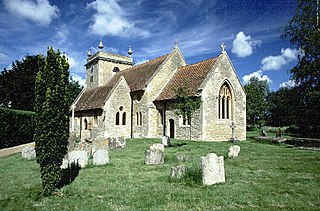
Kingston Lisle is a village and civil parish in the Vale of White Horse, England, about 4+1⁄2 miles (7 km) west of Wantage and 5 miles (8 km) south-southeast of Faringdon. The parish includes the hamlet of Fawler, about 1⁄2 mile (800 m) west of Kingston Lisle village. The 2011 Census recorded the parish population as 225. Kingston Lisle was part of Berkshire until the 1974 local government boundary changes transferred the Vale of White Horse to Oxfordshire.
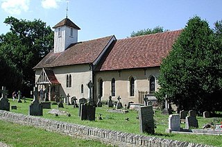
Stadhampton is a village and civil parish about 7 miles southeast of Oxford in South Oxfordshire, England. Stadhampton is close to the River Thame, a tributary of the River Thames. The village was first mentioned by name in 1146, and was in the ownership of the bishops of Lincoln, the crown, and various Oxford colleges for most of subsequent history. The village includes several buildings of historical and architectural interest, including a parish church with features dating back to the 12th-century.

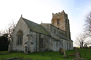
Mareham le Fen is a village and civil parish about 6 miles (10 km) south from the town of Horncastle, Lincolnshire, England. The hamlet of Mareham Gate lies about 0.5 miles (0.8 km) south from the village, and it is believed that the deserted medieval village (DMV) of Birkwood is situated nearby.

East Dean is a village and civil parish in the District of Chichester in West Sussex, England. The village is in a valley in the South Downs, 5+1⁄2 miles (9 km) north-northeast of Chichester on a narrow road between Singleton on the A286 and Upwaltham on the A285 road. The village pond is considered to be the source of the River Lavant.

Edwardstone is a village and civil parish in the Babergh district, in the county of Suffolk, England. The parish contains the hamlets of Mill Green, Priory Green, Round Maple and Sherbourne Street, and Edwardstone Woods, a Site of Special Scientific Interest. The parish touches Boxford, Great Waldingfield, Groton, Little Waldingfield, Milden and Newton.

Burton Pedwardine is a hamlet and civil parish in the district of North Kesteven, Lincolnshire, England. The population at the 2011 census was 187. The hamlet is situated approximately 4 miles (6 km) south-east from the market town of Sleaford and south-west of the village of Heckington.

Selworthy is a small village and civil parish 5 kilometres (3 mi) from Minehead in Somerset, England. It is located in the National Trust's Holnicote Estate on the northern fringes of Exmoor. The parish includes the hamlets of Bossington, Tivington, Lynch, Brandish Street and Allerford.
Middleton is a village and civil parish in the Braintree District of Essex, England. The village is 1 mile (1.6 km) south from the Ballingdon suburb of the market town of Sudbury. The parish, which is 2 miles (3.2 km) east to west and less than 1 mile north to south, is bordered at the north and east by the county of Suffolk, at the west by the Essex parish of Bulmer and the A131 road, and at the south by the Essex parishes of Little Henny and Great Henny. The River Stour also forms the eastern border.

High Toynton is a village and civil parish in the East Lindsey district of Lincolnshire, England. It is situated approximately 1.5 miles (2.4 km) east from the town of Horncastle, and in the Lincolnshire Wolds, a designated Area of Outstanding Natural Beauty.

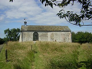
Wildmore is a civil parish in the East Lindsey district of Lincolnshire, England. It is situated approximately 9 miles (14 km) north-west from the town of Boston and 11 miles (18 km) south from Horncastle.

Claxby St Andrew, is a village and civil parish about 3 miles (5 km) south of Alford, in the East Lindsey district of Lincolnshire, England.

Langton by Spilsby, sometimes called Langton by Partney, is a village and civil parish in the East Lindsey district of Lincolnshire, England. It is situated approximately 4 miles (6 km) north from the town of Spilsby, Lincolnshire. The civil parish includes the hamlet of Sutterby. From the 2011 census the population is included in the civil parish of Sausthorpe.
Mareham on the Hill is a village and civil parish about 2.5 miles (4.0 km) south-east from the town of Horncastle, Lincolnshire, England.

North Cotes or North Coates is a village and civil parish in the East Lindsey district of Lincolnshire, England. It is situated close to the coast, 4 miles (6 km) to the east, and 10 miles (16 km) north-east from the town of Louth.

Sutton St James is a village and civil parish in the South Holland district of Lincolnshire, England, about four miles (6.4 km) south-west of Long Sutton.

