
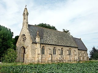
Sausthorpe is a small village and civil parish in the East Lindsey district of Lincolnshire, England, 8 miles (13 km) east of Horncastle and 3 miles (4.8 km) north-west of Spilsby. It lies on the southern edge of the Lincolnshire Wolds – a designated Area of Outstanding Natural Beauty – in the valley of the River Lymn. Farming remains the dominant economic activity in the area. The population was 305 in the 2011 census and estimated at 306 in 2019.

Welby is an English village and civil parish in the South Kesteven district of Lincolnshire. The population of the civil parish was 169 in 82 households at the 2011 census. It lies 4.5 miles (7 km) north-east of Grantham and 0.5 miles (0.8 km) east of the old Roman road Ermine Street. The neighbouring villages are Aisby, Oasby, and Heydour.

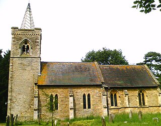
Laceby is a village and civil parish in North East Lincolnshire, England. It is situated on the A46 road, just outside the western boundary of Grimsby. Laceby's population at the 2001 Census was 2,886, increasing to 3,259 at the 2011 Census. The village is noted for its parish church, parts of which date to the 12th century.

Moorby is a small village in the East Lindsey district of Lincolnshire, England. The village is situated 4 miles (6 km) south-east from Horncastle and 1 mile (1.6 km) east from Wood Enderby. The village is in the civil parish of Claxby with Moorby, where Claxby refers to Claxby Pluckacre. Moorby has a population of about 50 inhabitants. At the 2011 census the population remained less than 100 and in included in the civil parish of Wood Enderby.

Huttoft is a village in the East Lindsey district of Lincolnshire, England, about 4 miles (6 km) east of the market town of Alford, on the A52 road between Ingoldmells and Sutton-on-Sea. John Betjeman, later England's Poet Laureate, visited Huttoft in the 1940s and devoted a poem to its parish church.
Brothertoft is a village in Lincolnshire, England, about 4 miles (6.4 km) northwest from the market town of Boston. It is part of the civil parish of Holland Fen with Brothertoft.

Glentham is a village and civil parish in the West Lindsey district of Lincolnshire, England. It is situated on the A631, 6 miles (9.7 km) west from Market Rasen, and 2 miles (3.2 km) east from Caenby Corner and the A15. The village includes the hamlet of Caenby.
Brattleby is a village and civil parish in the West Lindsey district of Lincolnshire, England. The population of the civil parish at the 2011 census was 111, having slightly fallen from a figure of 113 quoted on the 2001 census. It is situated 5 miles (8 km) north of Lincoln, to the west of the A15, and near to RAF Scampton.

Heighington is a village and civil parish in the North Kesteven district of Lincolnshire, England. It is situated about 4 miles (6 km) south-east from the city and county town of Lincoln.

Ludford is a village and civil parish in the East Lindsey district of Lincolnshire, England. The parish is composed of the villages of Ludford Magna and Ludford Parva.

Friskney is a village and civil parish within the East Lindsey district of Lincolnshire, England.

Fulletby is a village and a civil parish in the East Lindsey district of Lincolnshire, England. It is in the Lincolnshire Wolds, and 3 miles (5 km) north-east from Horncastle, 9 miles (14 km) south from Louth, and 8 miles (13 km) north-west from Spilsby. The parish covers approximately 1,950 acres (8 km2). At the time of the 2011 census the population remained less than 100 and is included in the civil parish of Low Toynton.
Fulstow is a marsh village and civil parish in the East Lindsey district of Lincolnshire, England. It is situated 6 miles (10 km) north of Louth and 8 miles (13 km) south of Grimsby.
Hagnaby is a small village in the East Lindsey district of Lincolnshire, England. It is 4 miles (6.4 km) south-west from Spilsby, in the civil parish of East Kirkby.

Heapham is a village and civil parish in the West Lindsey district of Lincolnshire, England, and 5 miles (8.0 km) south-east from Gainsborough.

South Willingham is a village and civil parish in the East Lindsey district of Lincolnshire, England, and partly within the Lincolnshire Wolds Area of Outstanding Natural Beauty,. It is situated 1 mile (2 km) south of the A157 Lincoln to Louth road, 15 miles (24 km) west of Lincoln, where the central Lincolnshire Vale and the Lincolnshire Wolds meet. Its population was 160 at the 2011 census, down from a maximum of 341 in 1851.

Gayton le Wold is a village and civil parish in the East Lindsey district of Lincolnshire, England. It lies 6 miles (10 km) west from Louth, 3 miles (5 km) north from Donington on Bain, and to the south of the A157. The parish includes Biscathorpe 1 mile (1.6 km) to the south-west.

Langton by Spilsby, sometimes called Langton by Partney, is a village and civil parish in the East Lindsey district of Lincolnshire, England. It is situated approximately 4 miles (6 km) north from the town of Spilsby, Lincolnshire. The civil parish includes the hamlet of Sutterby. From the 2011 census the population is included in the civil parish of Sausthorpe.

Middle Rasen is a village and civil parish in the West Lindsey district of Lincolnshire, England, located about 1.5 miles (2.4 km) west from the town of Market Rasen. The population of the civil parish at the 2011 census was 2,043.
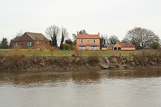
Walkerith is a hamlet within the civil parish of East Stockwith, in the West Lindsey district of Lincolnshire, England. It lies on the east bank of the River Trent, 2.5 miles (4.0 km) north-west from Gainsborough and 1.5 miles (2.4 km) south from East Stockwith.

