
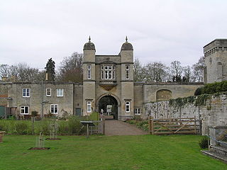
Horncastle is a town and civil parish in Lincolnshire, 17 miles (27 km) east of the county town of Lincoln. Its population of 6,815 at the 2011 census was estimated to be 7,123 in 2019. A section of the ancient Roman walls remains.

Louth is a market town and civil parish in the East Lindsey district of Lincolnshire, England.

The Lincolnshire Wolds are a range of low hills in the county of Lincolnshire, England which run roughly parallel with the North Sea coast, from the Humber Estuary in the north-west to the edge of the Lincolnshire Fens in the south-east. They are a designated Area of Outstanding Natural Beauty (AONB), and the highest area of land in eastern England between Yorkshire and Kent.

The Belmont transmitting station is a broadcasting and telecommunications facility next to the B1225, one mile west of the village of Donington on Bain in the civil parish of South Willingham, near Market Rasen and Louth in Lincolnshire, England. It is owned and operated by Arqiva.

The River Bain is a river in Lincolnshire, England, and a tributary of the River Witham.

Coningsby is a village and civil parish in the East Lindsey district in Lincolnshire, England, it is situated on the A153 road, adjoining Tattershall on its western side, 13 miles (22 km) north west of Boston and 8 miles (13 km) south west from Horncastle.
Easton is a village and civil parish in the South Kesteven district of Lincolnshire, England. It is situated almost 2 miles (3.2 km) north from Colsterworth, and 1 mile (1.6 km) east from the A1 road. It is in the civil parish of Stoke Rochford.

Belchford is a village and civil parish in the East Lindsey district of Lincolnshire, England. The village is situated approximately 4 miles (6 km) north of Horncastle and just to the east of the A153. At the 2011 Census, the population of the parish was 255.

Quadring is a small village and civil parish in the South Holland district of Lincolnshire. It lies on the A152, 2 miles (3.2 km) north-east of Gosberton, and 2 miles south-east of Donington.
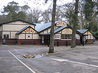
Woodhall Spa is a former spa town and civil parish in Lincolnshire, England, on the southern edge of the Lincolnshire Wolds, 6 miles (10 km) south-west of Horncastle, 23 miles (37 km) west of Skegness, 15 miles (24 km) east-south-east of Lincoln and 17 miles (27 km) north-west of Boston. It is noted for its mineral springs, cinema and its Second World War association with the RAF 617 Squadron. The cinema has the last remaining rear screen projector in the country.

Goulceby is a village and civil parish in the East Lindsey district of Lincolnshire, England. It is situated 7 miles (11 km) south-west from the market town of Louth, and lies in the Lincolnshire Wolds, an Area of Outstanding Natural Beauty.

South Thoresby is a village and civil parish in the East Lindsey district of Lincolnshire, England. It is situated 10 miles (16 km) north-east from Horncastle and 8 miles (13 km) south-east from Louth.

Kirkby on Bain is a village and civil parish in the East Lindsey district of Lincolnshire, England. It lies on the River Bain between Horncastle and Coningsby, and just west of the A153 road. Close to the north is the village of Haltham.

Skendleby is a small village and civil parish in the East Lindsey district of Lincolnshire, England. It is situated near to the A158 and lies 35 miles (56 km) east from the county town Lincoln, and about 4 miles (6 km) north-east from the town of Spilsby. The village stands near the south-eastern edge of the Lincolnshire Wolds.

Haltham is a village and civil parish in the East Lindsey district of Lincolnshire, England. The population of the civil parish at the 2011 Census was 122. It is situated 4 miles (6.4 km) south from the town of Horncastle, and on the east bank of the River Bain in the Lincolnshire Wolds, a designated Area of Outstanding Natural Beauty.

South Willingham is a village and civil parish in the East Lindsey district of Lincolnshire, England, and partly within the Lincolnshire Wolds Area of Outstanding Natural Beauty. At South Willingham is Belmont transmitting station, the second tallest structure in the UK.

Gayton le Wold is a village and civil parish in the East Lindsey district of Lincolnshire, England. It lies 6 miles (10 km) west from Louth, 3 miles (5 km) north from Donington on Bain, and to the south of the A157. The parish includes Biscathorpe 1 mile (1.6 km) to the south-west.

Stenigot is a village in the East Lindsey district of Lincolnshire, England. It is in the Lincolnshire Wolds, a designated Area of Outstanding Natural Beauty, about 6 miles (9.7 km) south-west from the town of Louth, and 1 mile (1.6 km) south-east from the village of Donington on Bain. It includes the hamlet of Cold Harbour. The population is included in the civil parish of Asterby.

Calcethorpe with Kelstern is a civil parish in the East Lindsey district of Lincolnshire, England. It is situated west from the market town of Louth, and in the Lincolnshire Wolds, an Area of Outstanding Natural Beauty.
St. Mary's Church, Horncastle, Lincolnshire, England, dates from the early 13th century and is dedicated to Saint Mary. It serves the Ecclesiastical Parish of Horncastle and a grade II* listed building that was heavily restored by Ewan Christian between 1859 and 1861.

