
Ancaster is a village and civil parish in the South Kesteven district of Lincolnshire, England, on the site of a Roman town. The population of the civil parish was 1,317 at the 2001 census increasing to 1,647 at the 2011 census. The civil parish includes the settlements of Sudbrook and West Willoughby.

Hutton Cranswick is a village and civil parish in the East Riding of Yorkshire, England. It is situated approximately 3 miles (5 km) south from Driffield town centre, and on the A164 road.

Amcotts is a village and civil parish in the North Lincolnshire district of Lincolnshire, England, and on the Isle of Axholme. The village is situated north-west from Scunthorpe, and on the west bank of the River Trent facing Flixborough on the east bank. The 2001 Census recorded a population of 219 for the parish, increasing to 262 at the 2011 census.

Aslackby and Laughton is a civil parish in the South Kesteven district of Lincolnshire, England. According to the 2001 census the parish had a population of 243, in 102 households. increasing slightly to 251 in 118 households at the 2011 census. It consists of the village of Aslackby, the hamlet of Laughton, and scattered farms, and part of the hamlet of Graby.

Leadenham is a village and civil parish in North Kesteven district of Lincolnshire, England. The population of the civil parish at the 2011 census was 410. It lies 11 miles (18 km) north from Grantham, 14 miles south of Lincoln and 9 miles north west of Sleaford on the A607 between Welbourn and Fulbeck, and at the southern edge of the Lincoln Cliff.

Keyingham is a village and civil parish in the East Riding of Yorkshire, England. The village is situated approximately 10 miles (16 km) east of Kingston upon Hull city centre and lies on the A1033 road.
Scawby is a village and civil parish in North Lincolnshire, England. It is situated 2 miles (3 km) south-west from Brigg, and just east from the A15 road, and south from the M180 motorway. According to the 2001 Census, Scawby population was 2,277, reducing slightly to 2,243 at the 2011 census.

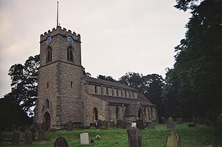
Hough-on-the-Hill is a village and civil parish in the South Kesteven district of Lincolnshire, England. The population of the civil parish including Brandon was 399 at the 2011 census. It is situated approximately 7 miles (11 km) due north from the market town of Grantham. The hamlets of Gelston and Brandon are part of the parish. Hough-on-the-Hill is on a significant rise, hence the name.
Old Somerby is a village and civil parish in the South Kesteven district of Lincolnshire, England, 3 miles (5 km) south-east of Grantham. It lies on the B1176 road, the village centre being about 1 mile (1.6 km) east of its junction with the A52 and B6403, and adjacent to the East Coast Main Line.

Grainthorpe is a small village and civil parish in the East Lindsey district of Lincolnshire, England. It is situated 7 miles (11 km) north-east from the town of Louth, and approximately 3 miles (5 km) from the Lincolnshire coast. The civil parish includes the hamlets of Wragholme to the north-west, and Ludney to the south-east. The population of Conisholme is included in the 2011 census.

Haltham is a village and civil parish in the East Lindsey district of Lincolnshire, England. The population of the civil parish at the 2011 Census was 122. It is situated 4 miles (6.4 km) south from the town of Horncastle, and on the east bank of the River Bain in the Lincolnshire Wolds, a designated Area of Outstanding Natural Beauty.

Hallington is a small village and civil parish in the East Lindsey district of Lincolnshire, England. It is situated 2 miles (3 km) south-west from the town of Louth in the Lincolnshire Wolds, a designated Area of Outstanding Natural Beauty. The population of the village is included in the civil parish of Welton Le Wold.

Knaith is a village and civil parish about 3 miles (5 km) south of the town of Gainsborough in the West Lindsey district of Lincolnshire, England. The population of the civil parish at the 2011 census was 335.

Lutton is a village and civil parish in the South Holland district of Lincolnshire, England. The population of the civil parish at the 2011 census was 1,261. It is situated about 4 miles (6 km) north-east from the town of Holbeach. The village has been known by the alternative name of Sutton St Nicholas. The civil parish comprises the village of Lutton, with Lutton Marsh to the north-east and Lutton Garnsgate to the south-west.

Market Stainton is a village and civil parish in the East Lindsey district of Lincolnshire, England. It is situated approximately 7 miles (11 km) north from the market town of Horncastle.

Rowston is a village and civil parish in the North Kesteven district of Lincolnshire, England, situated approximately 6 miles (10 km) north from the town of Sleaford. The population of the civil parish at the 2011 census was 178.

Springthorpe is a village and civil parish in the West Lindsey district of Lincolnshire, England. The population of the civil parish at the 2011 census was 138. It is situated approximately 4 miles (6 km) east from the town of Gainsborough.

Northorpe is a village and civil parish in the West Lindsey district of Lincolnshire, England, about 8 miles (13 km) north-east from the town of Gainsborough. The population of the civil parish at the 2011 census was 126.

Stenigot is a village in the East Lindsey district of Lincolnshire, England. It is situated in the Lincolnshire Wolds, a designated Area of Outstanding Natural Beauty, about 6 miles (9.7 km) south-west from the town of Louth, and 1 mile (1.6 km) south-east from the village of Donington on Bain. It includes the hamlet of Cold Harbour. The population is included in the civil parish of Asterby.

Weston is a village and civil parish in the South Holland district of Lincolnshire, England. It is situated approximately 2 miles (3 km) north-east from the town of Spalding. The Civil Parish also includes Weston Hills. The population of the civil parish including Austendike was at the 2011 census 2,054.

