Kirkby on Bain

Last updated

Kirkby on Bain
  • Kirkby
St,Mary's church, Kirkby-on-Bain, Lincs. - geograph.org.uk - 147536.jpg
St Mary's Church, Kirkby-on-Bain
Lincolnshire UK location map.svg
Red pog.svg
Kirkby on Bain
Location within Lincolnshire
Area7.31 km2 (2.82 sq mi)
Population295 (2011) [1]
  Density 40/km2 (100/sq mi)
OS grid reference TF241626
  London 115 mi (185 km)  S
Civil parish
  • Kirkby on Bain
District
Shire county
Region
Country England
Sovereign state United Kingdom
Post town WOODHALL SPA
Postcode district LN10
Dialling code 01526
Police Lincolnshire
Fire Lincolnshire
Ambulance East Midlands
UK Parliament
List of places
UK
England
Lincolnshire
53°08′46″N0°08′37″W / 53.146215°N 0.1435°W / 53.146215; -0.1435

Kirkby on Bain is a village and civil parish in the East Lindsey district of Lincolnshire, England. [2] It lies on the River Bain between Horncastle and Coningsby, and just west of the A153 road. Close to the north is the village of Haltham.

Contents

History

The old watermill on the River Bain in the centre of the village. Weir and disused watermill on river Bain - geograph.org.uk - 1959919.jpg
The old watermill on the River Bain in the centre of the village.

Formerly known as Kirkby Super Bain, the name comes from the Old Norse kîrkĵu + býr (Church settlement), [3] with the village dating back to at least the Viking Age.

Ebrington Arms

The Ebrington Arms village pub Ebrington Arms pub, Kirkby on Bain - geograph.org.uk - 3595136.jpg
The Ebrington Arms village pub

The village public house is the Ebrington Arms on Main Street which dates back to at least the 16th Century. [4] [5] It was popular with airmen from the nearby RAF Woodhall Spa famed for its links with the 617 Squadron Dambusters.

St. Mary's Church

The parish church is dedicated to St Mary, [6] and is in the Bain Valley Group of churches. It dates back to Norman times, and the parish records to 1562. [7] The church was largely rebuilt in 1802 and expanded in 1879–82.

Notable residents

Geography

Kirkby on Bain lies within the glacial Bain Valley at the confluence of River Bain and Haltham Beck. The Bain was canalised into the Horncastle Canal in the 1790s with the Old Course now little more than a stream in many places and dry in others.

North

River Bain (Horncastle Canal) looking south towards Kirkby on Bain from atop Red Mill Bridge River Bain, Haltham - geograph.org.uk - 102301.jpg
River Bain (Horncastle Canal) looking south towards Kirkby on Bain from atop Red Mill Bridge

To the north stretches the shallow glacial valley of the River Bain. Along the valley floor and flood plain the land is largely pastoral farmland used for rearing cattle and sheep, whilst further away from the river the land is more arable.

South

Bridleway through Kirkby Gravel Pits Nature Reserve Bridle path and nature reserve near to Kirkby on Bain. - geograph.org.uk - 162506.jpg
Bridleway through Kirkby Gravel Pits Nature Reserve

To the south along the valley are sand and gravel pits, many of them now long disused and some transformed into Kirkby Gravel Pits Nature Reserve, which is managed by Lincolnshire Wildlife Trust. The nature reserve is very biodiverse, and is one of very few inland sites in the county which have been visited by Eurasian spoonbill. [8] [9]

East

West

Typical Lowland Heathland landscape of Kirkby Moor Nature Reserve Heather and bracken, Kirkby Moor - geograph.org.uk - 949598.jpg
Typical Lowland Heathland landscape of Kirkby Moor Nature Reserve

To the west are Kirkby and Roughton Moors; a landscape once dominated by Lowland Heath now restricted to Fox Hill, and beyond is Ostler's Plantation, a pine woodland owned by the Forestry Commission. In this landscape can be found Kirkby Moor and Moor Farm Nature Reserves, both SSSIs, and soon to be joined by the former airfield of RAF Woodhall Spa purchased by the Lincolnshire Wildlife Trust in September 2014. [10]

Related Research Articles

<span class="mw-page-title-main">Bolingbroke, Lincolnshire</span> Village in Lincolnshire, England

Bolingbroke, now called Old Bolingbroke, is a village and civil parish in the East Lindsey district of Lincolnshire, England. Its present boundaries were formed by the amalgamation of the Parishes of Bolingbroke and Hareby in 1739. The population at the 2011 census was 325.

<span class="mw-page-title-main">Horncastle</span> Town in Lincolnshire, England

Horncastle is a market town and civil parish in the East Lindsey district in Lincolnshire, England. It is 17 miles (27 km) east of Lincoln. Its population was 6,815 at the 2011 census and estimated at 7,123 in 2019. A section of the ancient Roman walls remains.

<span class="mw-page-title-main">Tattershall</span> Village and civil parish in the East Lindsey district of Lincolnshire, England

Tattershall is a village and civil parish in the East Lindsey district of Lincolnshire, England. It is situated on the A153 Horncastle to Sleaford road, 1 mile (1.6 km) east from the point where that road crosses the River Witham. At its eastern end, Tattershall adjoins the village of Coningsby, with the two being separated by the River Bain and is 1 mile (1.6 km) south-east from the hamlet Tattershall Thorpe.

<span class="mw-page-title-main">River Bain</span> River in Lincolnshire, England

The River Bain is a river in Lincolnshire, England, and a tributary of the River Witham.

<span class="mw-page-title-main">Coningsby</span> Town and civil parish in the East Lindsey district in Lincolnshire, England

Coningsby is a town and civil parish in the East Lindsey district in Lincolnshire, England, it is situated on the A153 road, adjoining Tattershall on its western side, 13 miles (21 km) north west of Boston and 8 miles (13 km) south west from Horncastle.

<span class="mw-page-title-main">East Kirkby</span> Village and civil parish in the East Lindsey district of Lincolnshire, England

East Kirkby is a village and civil parish in the East Lindsey district of Lincolnshire, England. It is situated 7 miles (11 km) south-east from Horncastle, and on the A155 road.

<span class="mw-page-title-main">Woodhall Spa</span> Former spa town and civil parish in Lincolnshire, England

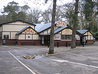
Woodhall Spa is a former spa town and civil parish in the East Lindsey district of Lincolnshire, England, on the southern edge of the Lincolnshire Wolds, 6 miles (10 km) south-west of Horncastle, 23 miles (37 km) west of Skegness, 15 miles (24 km) east-south-east of Lincoln and 17 miles (27 km) north-west of Boston. It is noted for its mineral springs, historic cinema and its Second World War association with the RAF 617 Squadron, commonly referred to as 'The Dambusters'.

<span class="mw-page-title-main">Roughton, Lincolnshire</span> Village and civil parish in the East Lindsey district of Lincolnshire, England

Roughton is a village and civil parish in the East Lindsey district of Lincolnshire, England. The parish population was 644 in 2011.

<span class="mw-page-title-main">Viking Way</span> 147 mile footpath in England

The Viking Way is a long distance trail in England running 147 miles (237 km) between the Humber Bridge in North Lincolnshire and Oakham in Rutland.

<span class="mw-page-title-main">RAF Woodhall Spa</span> Former Royal Air Force station in Lincolnshire, England

Royal Air Force Woodhall Spa, or more simply RAF Woodhall Spa, is a former Royal Air Force satellite station located 2 miles (3.2 km) north of Coningsby, Lincolnshire and 16 miles (26 km) southeast of Lincoln, Lincolnshire, England.

<span class="mw-page-title-main">Kirkstead</span> Ancient village and former parish on the River Witham in Lincolnshire, England

Kirkstead is a village and former civil parish now in the parish of Woodhall Spa, in the East Lindsey district, in Lincolnshire, England, on the River Witham. In 1961 the parish had a population of 85. It was merged with the civil parish of Woodhall Spa in 1987.

Whisby Moor is a small moor situated close to the A46 road, west of North Hykeham, in the North Kesteven district of Lincolnshire, England.

<span class="mw-page-title-main">Woodhall Spa railway station</span> Former railway station in Lincolnshire, England

Woodhall Spa railway station was a station in Woodhall Spa, Lincolnshire on a small branch line running north from Woodhall Junction to Horncastle. Both the station and the line are now closed.

<span class="mw-page-title-main">Ostler's Plantation</span>

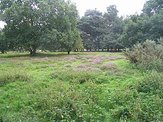
Ostler's Plantation is a woodland east of Woodhall Spa, Lincolnshire on Kirkby Moor. It has public access and lies to the west of an open area of Lowland Heath, the Kirkby Moor Nature Reserve; both are noted for having large numbers of adders.

<span class="mw-page-title-main">Tattershall Thorpe</span> Hamlet and civil parish in the East Lindsey district of Lincolnshire, England

Tattershall Thorpe is a hamlet and civil parish in the East Lindsey district of Lincolnshire, England. It is situated approximately 3 miles (5 km) south from Woodhall Spa, and 1 mile (1.6 km) north-east from Tattershall.

<span class="mw-page-title-main">South Willingham</span> Village and civil parish in Lincolnshire, England

South Willingham is a village and civil parish in the East Lindsey district of Lincolnshire, England, and partly within the Lincolnshire Wolds Area of Outstanding Natural Beauty,. It is situated 1 mile (2 km) south of the A157 Lincoln to Louth road, 15 miles (24 km) west of Lincoln, where the central Lincolnshire Vale and the Lincolnshire Wolds meet. Its population was 160 at the 2011 census, down from a maximum of 341 in 1851.

<span class="mw-page-title-main">Kirkby Moor, Lincolnshire</span> Human settlement in England

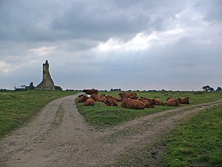
Kirkby Moor is an elevated area of lowland heath, woodland and farmland in central Lincolnshire between the villages of Woodhall Spa to the west and Kirkby on Bain to the east. Roughton Moor lies to the north and the former RAF Woodhall Spa and the Lincolnshire Fens beyond to the south.

References

  1. Census,
  2. https://kirkbyonbain.wordpress.com/ [ user-generated source ]
  3. English, University of Nottingham - Institute of Name Studies School of. "Key to English Place-names". kepn.nottingham.ac.uk. Retrieved 20 September 2016.
  4. "About The Ebrington Arms, Kirkby-on-Bain, Lincolnshire" . Retrieved 20 September 2016.
  5. "About". 7 September 2015. Retrieved 20 September 2016.
  6. "St Marys, Kirkby On Bain". British Listed Buildings. English Heritage. Retrieved 7 July 2011.
  7. "GENUKI".
  8. Lincolnshire Wildlife Trust - Kirkby Gravel Pits
  9. Lincolnshire Wildlife Trust - Kirkby Gravel Pits
  10. "Lincolnshire Wildlife Trust completes purchase of Woodhall Spa Airfield | Lincolnshire Wildlife Trust". www.lincstrust.org.uk. Retrieved 20 September 2016.