
Bolingbroke, now called Old Bolingbroke, is a village and civil parish in the East Lindsey district of Lincolnshire, England. Its present boundaries were formed by the amalgamation of the Parishes of Bolingbroke and Hareby in 1739. The population at the 2011 census was 325.

Burwell is a small village and Civil parish in the East Lindsey district of Lincolnshire, England. It is situated on the A16 road, and north from Spilsby. The village covers approximately 2200 acres (9 km2).
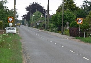
Gedney Drove End is a village in the civil parish of Gedney and the South Holland district of Lincolnshire, England. It is 40 miles (64 km) south-east from the city and county town of Lincoln, and 12 miles (20 km) from both Boston at the north-west and King's Lynn at the south-east.
Aby is a village in the East Lindsey district of Lincolnshire, England. It is approximately 30 miles (48 km) east from the city and county town of Lincoln and 8 miles (13 km) south-east from Louth. Aby is part of the civil parish of Aby with Greenfield.

Addlethorpe is a small village situated just off the A52 west of Ingoldmells in the East Lindsey district of Lincolnshire, England.
Barrowby is a village and civil parish in the South Kesteven district of Lincolnshire, England. It is 2 miles (3.2 km) west of Grantham town centre in a position overlooking the Vale of Belvoir. It has a Grade I listed parish church. The hamlet of Casthorpe is part of the parish. The 2001 Census listed 795 households and a population of 1,996, which fell to 840 households with 1,952 inhabitants at the 2011 census. It was estimated at 1,986 in 2019.

Swineshead is a village and civil parish in Lincolnshire, England, approximately 7 miles (11 km) west of the town of Boston. The population of the civil parish including Baythorpe was 2,810 at the 2011 census. The parish includes the areas of Swineshead Bridge and North End to the north, Fenhouses and Blackjack to the east, and Drayton to the south.
Habrough is a village and civil parish in North East Lincolnshire, England, 8 miles (13 km) north-west of Grimsby and 3 miles (5 km) inland from the River Humber at the southern edge of the A180 road, just west of Immingham and south of South Killingholme. Humberside Airport is 4 miles (6.4 km) to the south-west.

Amcotts is a village and civil parish in the North Lincolnshire district of Lincolnshire, England, and on the Isle of Axholme. The village is situated north-west from Scunthorpe, and on the west bank of the River Trent facing Flixborough on the east bank. The 2001 Census recorded a population of 219 for the parish, increasing to 262 at the 2011 census.

Partney is a small village and civil parish in the East Lindsey district of Lincolnshire, England. It is situated 3 miles (4.8 km) north of Spilsby, and in the Lincolnshire Wolds. The village was the birthplace of Henry Stubbe, the noted 17th-century Intellectual.
Scawby is a village and civil parish in North Lincolnshire, England. It is situated 2 miles (3 km) south-west from Brigg, and just east from the A15 road, and south from the M180 motorway. According to the 2001 Census, Scawby population was 2,277, reducing slightly to 2,243 at the 2011 census.

Legsby is a small village and civil parish in the West Lindsey district of Lincolnshire, England. The population of the civil parish at the 2011 census was 193. It is situated approximately 13 miles (20 km) north-east from the city and county town of Lincoln and 3 miles (5 km) south-east from the town of Market Rasen.

Raithby by Spilsby or Raithby is a village and civil parish in the East Lindsey district of Lincolnshire, England. It is situated about 2 miles (3.2 km) north-west from the town of Spilsby.

Hallington is a small village and civil parish in the East Lindsey district of Lincolnshire, England. It is situated 2 miles (3 km) south-west from the town of Louth in the Lincolnshire Wolds, a designated Area of Outstanding Natural Beauty. The population of the village is included in the civil parish of Welton Le Wold.

Market Stainton is a village and civil parish in the East Lindsey district of Lincolnshire, England. It is situated approximately 7 miles (11 km) north from the market town of Horncastle.

Middle Rasen is a village and civil parish in the West Lindsey district of Lincolnshire, England, located about 1.5 miles (2.4 km) west from the town of Market Rasen. The population of the civil parish at the 2011 census was 2,043.

Wildsworth is a village and civil parish in the West Lindsey district of Lincolnshire, England. It is situated on the eastern bank of the River Trent, and approximately 5 miles (8 km) north from Gainsborough. The population is included in the civil parish of East Ferry.

Toynton All Saints is a village and civil parish in the East Lindsey district of Lincolnshire, England, about 1.5 miles (2.4 km) south of the town of Spilsby.

Toynton St Peter is a village and civil parish in the East Lindsey district of Lincolnshire, England, approximately 2 miles (3 km) south from the town of Spilsby.

Weston is a village and civil parish in the South Holland district of Lincolnshire, England. It is situated approximately 2 miles (3 km) north-east from the town of Spalding. The Civil Parish also includes Weston Hills. The population of the civil parish including Austendike was at the 2011 census 2,054.

