
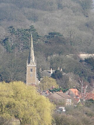
Horncastle is a town and civil parish in the East Lindsey district in Lincolnshire, 17 miles (27 km) east of Lincoln. Its population was 6,815 at the 2011 census and estimated at 7,123 in 2019. A section of the ancient Roman walls remains.
The A15 is a major road in England. It runs north from Peterborough via Market Deeping, Bourne, Sleaford and Lincoln along a variety of ancient, Roman, and Turnpike alignments before it is interrupted at its junction with the M180 near Scawby. The road restarts 10 miles (16 km) east, and then continues north past Barton-upon-Humber, crossing the Humber on the Humber Bridge before terminating at Hessle near Kingston upon Hull.
The A59 is a major road in England which is around 109 miles (175 km) long and runs from Wallasey, Merseyside to York, North Yorkshire. The alignment formed part of the Trunk Roads Act 1936, being then designated as the A59. It is a key route connecting Merseyside at the M53 motorway to Yorkshire, passing through three counties and connecting to various major motorways. The road is a combination of historical routes combined with contemporary roads and a mixture of dual and single carriageway. Sections of the A59 in Yorkshire closely follow the routes of Roman roads, some dating back to the Middle Ages as salt roads, whilst much of the A59 in Merseyside follows Victorian routes which are largely unchanged to the present day.

The A52 is a major road in the East Midlands, England. It runs east from a junction with the A53 at Newcastle-under-Lyme near Stoke-on-Trent via Ashbourne, Derby, Stapleford, Nottingham, West Bridgford, Bingham, Grantham, Boston and Skegness to the east Lincolnshire coast at Mablethorpe. It is approximately 147 miles (237 km) long.

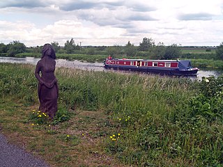
The River Bain is a river in Lincolnshire, England, and a tributary of the River Witham.

Coningsby is a village and civil parish in the East Lindsey district in Lincolnshire, England, it is situated on the A153 road, adjoining Tattershall on its western side, 13 miles (22 km) north west of Boston and 8 miles (13 km) south west from Horncastle.
Barkston is an English village and civil parish in the South Kesteven district of Lincolnshire. The parish population was 497 at the 2001 census and 493 at the 2011 census. The village lies about 4 miles (6 km) north of the market town of Grantham, on the A607, just south of the junction with the A153 to Ancaster.
Lincolnshire is a large county in England with a sparse population distribution, which leads to problems funding all sorts of transport. The transport history is long and varied, with much of the road network still based on the Roman model, and the once extensive rail network a shadow of its former self.

Ruskington is a large village and civil parish in the North Kesteven district of Lincolnshire, England, located approximately 4 miles (7 km) north of Sleaford on the north–south B1188 road and slightly north of the A153 road. The village contains approximately 2,200 dwellings and is approximately 1 mile (1.6 km) in length, measured from east to west. The population of the civil parish was 5,169 at the 2001 census, increasing to 5,637 at the 2011 census.

The Peterborough–Lincoln line is a railway line linking Peterborough and Lincoln Central, via Sleaford and Spalding. Between Lincoln and Spalding, the line follows the route of the former Great Northern and Great Eastern Joint Railway.

The A17 road is a mostly single carriageway road linking Newark-on-Trent in Nottinghamshire, England, to King's Lynn in Norfolk. It stretches for a distance of 62 miles travelling across the flat fen landscapes of southern Lincolnshire and western Norfolk and links the East Midlands with East Anglia. The road is notable for its numerous roundabouts and notoriously dangerous staggered junctions and also for its most famous landmark, the Cross Keys Bridge at Sutton Bridge close to the Lincolnshire/Cambridgeshire/Norfolk borders which carries the road over the River Nene.

U.S. Highway 12 in the U.S. state of Wisconsin runs east–west across the western to southeast portions of the state. It enters from Minnesota running concurrently with Interstate 94 (I-94) at Hudson, parallels the Interstate to Wisconsin Dells, and provides local access to cities such as Menomonie, Eau Claire, Black River Falls, Tomah and Mauston. It then provides an alternative route for traffic between northwestern Wisconsin and Madison and is the anchor route for the Beltline Highway around Madison. Finally, it serves southeastern Wisconsin, connecting Madison with Fort Atkinson, Whitewater, Elkhorn and Lake Geneva. The West Beltline Highway and the segment between Elkhorn and Genoa City are freeways, and the segment between Sauk City and Middleton is an expressway. The remainder of the road is a two-lane surface road or an urban multi-lane arterial. Between Hudson and west of Warrens, the road closely parallels the former main line of the Omaha Road, now operated by Union Pacific Railroad.

The A158 road is a major route that heads from Lincoln in the west to Skegness on the east coast. The road is located entirely in the county of Lincolnshire and is single carriageway for almost its entirety. The road is approximately 40 miles (64 km) long. The road gets quite congested with holiday traffic during the summer.

The A607 is an A road in England that starts in Belgrave, Leicester and heads northeastwards through Leicestershire and the town of Grantham, Lincolnshire, terminating at Bracebridge Heath, a village on the outskirts of Lincoln. It is a primary route from Thurmaston to the A1 junction at Grantham.

The A631 is a road running from Sheffield, South Yorkshire to Louth, Lincolnshire in England. It passes through the counties of South Yorkshire, Nottinghamshire and Lincolnshire. The road has many towns on its route including Rotherham, Maltby, Gainsborough and Market Rasen. It is mostly single road throughout its length but has some stretches of dual carriageway as well.

The A1175 road is a road in south-west Lincolnshire, England. It runs between Stamford and Spalding, along the old A16 route.

South Willingham is a village and civil parish in the East Lindsey district of Lincolnshire, England, and partly within the Lincolnshire Wolds Area of Outstanding Natural Beauty,. It is situated 1 mile (2 km) south of the A157 Lincoln to Louth road, 15 miles (24 km) west of Lincoln, where the central Lincolnshire Vale and the Lincolnshire Wolds meet. Its population was 160 at the 2011 census, down from a maximum of 341 in 1851.
Branston and Mere is a civil parish in the North Kesteven district of Lincolnshire, England, about 4 miles (6 km) roughly south-east of Lincoln. The parish is a long strip between the RAF Waddington airfield and the River Witham near Bardney. The A15 road crosses the extreme west and the parish is bisected by the Sleaford to Lincoln railway line The civil parish was created in 1931, by merging the two former parishes of Branston and Mere.
The Boston, Sleaford and Midland Counties Railway opened a railway line between Grantham and Boston, through Sleaford, England. It opened in two stages, in 1857 and 1859.
The Grantham and Lincoln railway line was a line in Lincolnshire, built by the Great Northern Railway to shorten the distance between the town of Grantham and city of Lincoln. It had already formed a network in Lincolnshire, but the route from London and points south and west of Grantham was very indirect.

