
The A303 is a trunk road in southern England, running between Basingstoke in Hampshire and Honiton in Devon via Stonehenge. Connecting the M3 and the A30, it is part of one of the main routes from London to Devon and Cornwall. It is a primary A road throughout its length, passing through five counties.

The A40 is a trunk road which runs between London and Goodwick (Fishguard), Wales, and officially called The London to Fishguard Trunk Road (A40) in all legal documents and Acts. Much of its length within England has been superseded by motorways, such as the M40, and has lost its trunk road status, though it retains it west of Gloucester, including its length within Wales. It is approximately 260 miles (420 km) long. The eastern section from Denham, Buckinghamshire to Wheatley, Oxfordshire is better served by the M40 and its former function of linking London with Cheltenham and Gloucester has been taken by the M4, A419 and A417 via Swindon.

The M180 is a 25.5-mile (41 km) motorway in eastern England, starting at junction 5 on the M18 motorway in Hatfield, within the Metropolitan Borough of Doncaster, South Yorkshire, and terminating at Barnetby, Lincolnshire, some 10 miles (16 km) from the port of Immingham and 14 miles (23 km) from the port of Grimsby. The A180 road continues to the east for Grimsby, Cleethorpes and Immingham. Scunthorpe, Lincoln, Hull, Brigg, Bawtry and the Isle of Axholme can be accessed using the motorway. Humberside Airport, the now-closed Doncaster Sheffield Airport, and the Killingholme, Humber and Lindsey oil refineries are close to the motorway. The road forms part of the unsigned Euroroute E22 and is the main route along the south bank of the Humber Estuary.

The A46 is a major A road in England. It starts east of Bath, Somerset and ends in Cleethorpes, Lincolnshire, but it does not form a continuous route. Large portions of the old road have been lost, bypassed, or replaced by motorway development. Between Leicester and Lincoln the road follows the course of the Roman Fosse Way, but between Bath and Leicester, two cities also linked by the Fosse Way, it follows a more westerly course.

The A27 is a major road in England. It runs from its junction with the A36 at Whiteparish in the county of Wiltshire, follows the south coast of Hampshire and West Sussex, and terminates at Pevensey in East Sussex.
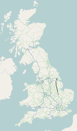
The A15 is a major road in England. It runs north from Peterborough via Market Deeping, Bourne, Sleaford and Lincoln along a variety of ancient, Roman, and Turnpike alignments before it is interrupted at its junction with the M180 near Scawby. The road restarts 10 miles (16 km) east, and then continues north past Barton-upon-Humber, crossing the Humber on the Humber Bridge before terminating at Hessle near Kingston upon Hull.
The A21 is a trunk road in Southern England, one of several which connect London and various commuter towns to the south coast. It provides a link to Hastings, East Sussex and parts of Kent. Half of the distance covered is over gently undulating terrain, with some hills and bends. Often traffic is slow-moving, particularly on weekdays on the short single carriageway stretches; and in summer with holiday traffic. Because of this, people have described the A21 as "a joke" and businesspeople have been reported to "hate coming down the A21". There have been many proposals to upgrade parts of the A21 in response to this.

The A31 is a major trunk road in southern England that runs from Guildford in Surrey to Bere Regis in Dorset. Its most well known section is the Hog's Back, a hilly ridge forming part of the North Downs, in the Surrey stretch between Guildford and Farnham.

The A63 is a major road in Yorkshire, England between Leeds and Kingston upon Hull. A section between North Cave and Hull forms the eastward continuation of the M62 motorway and is part of the unsigned Euroroute E20.

The N5 road is a national primary road in Ireland, connecting Longford town with Westport. It is the main access route from Dublin to most of County Mayo, including the county's largest towns, Castlebar, Ballina, and Westport.

The A417 is a main road in England, running from Streatley, Berkshire to Hope under Dinmore, Herefordshire. It is best known for its section between Cirencester and Gloucester where it has primary status and forms part of the link between the major settlements of Swindon and Gloucester.
The A428 road is a major road in central and eastern England. It runs between the cities of Coventry and Cambridge by way of the county towns of Northampton and Bedford. Together with the A421,, the eastern section of the A428 forms the route between Cambridge and Oxford. The A428 was formerly part of the main route from Birmingham to Felixstowe before the A14 was fully opened in 1993.
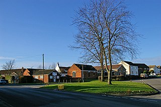
South Killingholme is a village and civil parish in North Lincolnshire, England. The population of the civil parish at the 2011 census was 1,108.

The A453 road was formerly the main trunk road connecting the English cities of Nottingham and Birmingham. However, the middle section of this mainly single-carriageway road has largely been downgraded to B roads or unclassified roads following the construction of the parallel M42-A42 link around 1990. The M42 was originally meant to pass further north than it does, and to join the M1 at Sandiacre in Derbyshire. The M42/A42 does not enter Derbyshire, but instead joins the M1 closer to the A453 junction at Kegworth. The A42 shadows the former A453 from Appleby Magna to Castle Donington. The road historically connected the East Midlands with the West Midlands.

The A18 is a road in England that links Doncaster in South Yorkshire with Ludborough in Lincolnshire, via Scunthorpe and Grimsby. Much of its route has been superseded by the M180 motorway.

The A180 is a primary route in northern England, that runs from the M180 motorway to Cleethorpes. The road is a continuation of the M180, but built to lower specifications: it is mainly dual two-lane without hard shoulders. The road is dual carriageway for 16.87 miles (27.15 km) from the M180 to Grimsby, and is a single carriageway road for 2 miles (3.2 km) between Grimsby and Cleethorpes beach.
The A5117 is a road in Cheshire, England. It runs between Shotwick (53.2374°N 2.9875°W) and Helsby (53.2613°N 2.7814°W) and connects the A550 at Woodbank to the M56. As such it forms a northerly bypass to Chester and a shorter route between the North West and North Wales than the A55.

The A556 is a road in England which extends from the village of Delamere in Cheshire West and Chester to the Bowdon Interchange in Cheshire East, bordering Greater Manchester. The road contains a mixture of single and dual carriageway sections and forms a large part of the route between Manchester and Chester. It also acts as a major access route to Chester/North Wales to the west and to Manchester to the east for the conurbation of towns and villages around the Dane Valley centering on Winsford and Northwich. The central part, which forms the Northwich Bypass between Davenham and Lostock Gralam, suffers because of the amount of commuter traffic from this area. The part of the route between the M6 motorway Junction 19 and the M56 motorway Junction 7 is a major route into Manchester and has been recently upgraded to a four-lane dual carriageway.

The Milton Keynes grid road system is a network of predominantly national speed limit, fully landscaped routes that form the top layer of the street hierarchy for both private and public transport in Milton Keynes, Buckinghamshire. The system is unique in the United Kingdom for its innovative use of street hierarchy principles: the grid roads run in between districts rather than through them. This arrangement permits higher speed limits due to the absence of buildings close to the roads – although more recently some have been limited in part to 40 mph (64 km/h). The grid road system also serves an important purpose of discouraging through-traffic from travelling through neighbourhoods and thus reduces traffic noise and pollution in pedestrian areas. Motor traffic is segregated from pedestrian and leisure cycling traffic, which uses the alternative Milton Keynes redway system. Almost all grid junctions are roundabouts, and the absence of traffic lights enables free and efficient movement of traffic.

The A631 is a road running from Sheffield, South Yorkshire to Louth, Lincolnshire in England. It passes through the counties of South Yorkshire, Nottinghamshire and Lincolnshire. The road has many towns on its route including Rotherham, Maltby, Gainsborough and Market Rasen. It is mostly single road throughout its length but has some stretches of dual carriageway as well.


