Cleveland is a land of hills and dales from the River Tees to Vale of Pickering, England. The name means “cliff-land”.

The A66 is a major road in Northern England, which in part follows the course of the Roman road from Scotch Corner to Penrith. It runs from east of Middlesbrough in North Yorkshire to Workington in Cumbria.

The North Riding of Yorkshire is a subdivision of Yorkshire, England, alongside York, the East Riding and West Riding. The riding's highest point is at Mickle Fell with 2,585 ft (788 metres).

Redcar and Cleveland is a borough with unitary authority status in North Yorkshire, England. Its main settlements are Redcar, South Bank, Eston, Brotton, Guisborough, Greater Eston, Loftus, Saltburn and Skelton. The borough had a resident population of 135,200 in 2011.
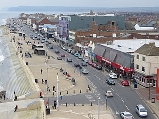
Redcar is a seaside town on the Yorkshire Coast in the Redcar and Cleveland unitary authority in the county of North Yorkshire, England. It is located 7 miles (11 km) east of Middlesbrough.

BBC Radio Tees is the BBC's local radio station serving the former county of Cleveland which comprises the unitary authorities of Hartlepool, Middlesbrough, Redcar and Cleveland and Stockton-on-Tees.

The Esk Valley Line is a railway line located in the north of England, covering a total distance of around 30 miles (48 km), running from Middlesbrough to Whitby. The line follows the course of the River Esk for much of its eastern half.

Redcar is a constituency represented in the House of Commons of the UK Parliament since 2019 by Jacob Young, a Conservative.

Middlesbrough South and East Cleveland is a constituency created in 1997 represented in the House of Commons of the UK Parliament since 2017 by Simon Clarke of the Conservative Party.

Marske-by-the-Sea is a village in the unitary authority of Redcar and Cleveland and the ceremonial county of North Yorkshire, England. It is located on the coast, between the seaside resorts of Redcar and Saltburn-by-the-Sea, although it is not itself a seaside resort. Marske is in the civil parish of Saltburn, Marske and New Marske and comprises the wards of Longbeck and St Germains.

Ormesby is an area which is split between Borough of Middlesbrough and Borough of Redcar and Cleveland in North Yorkshire, England. It is in the Middlesbrough part of the Teesside built up area.

Middlesbrough is a railway station on the Durham Coast Line, Esk Valley Line and Tees Valley Line. The station serves the town of Middlesbrough in North Yorkshire, England. It is owned by Network Rail and managed by TransPennine Express.
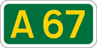
The A67 is a road in England that links Bowes in County Durham with Crathorne in North Yorkshire. The road from Middlesbrough to Darlington was previously the A66 road.
Newton under Roseberry is a village in the borough of Redcar and Cleveland and the ceremonial county of North Yorkshire, England. It is on the A173, between Great Ayton and Guisborough and is close to the base of Roseberry Topping.

Middlesbrough Council, formerly known as Middlesbrough Borough Council, is a unitary authority based in Middlesbrough in North Yorkshire, England. The authority has combined some duties with its nearby councils to form the Tees Valley Combined Authority. The borough is often considered to be larger than current borough boundaries, with a total built-up population of 174,700. It is in the statistical region of North East England.

The Teesdale Way is a long-distance walk between the Cumbrian Pennines and the North Sea coast of North Yorkshire in England. The walk is 100 miles (160 km) in length; it links in with other long-distance walks such as the Pennine Way and the E2 European Walk between Harwich and Stranraer.

The A172 is a major road in North Yorkshire, and the unitary authority of Middlesbrough, England. It runs from Ingleby Arncliffe to Middlesbrough. The road derives its adumbrated number from 1969 when a thoroughfare link connected South Teesside with the Lackenby Docks in Middlesbrough. Since further urban infrastructure development it has been extended into the North Yorkshire Moors, when it transforms into A174.

National Cycle Route 1 is a route of the National Cycle Network, running from Dover to Tain. The 1,264 mi-long (2,034-kilometre) cycle-path is located in the United Kingdom.

The Teesside Steelworks was a large steelworks that formed a continuous stretch along the south bank of the River Tees from the towns of Middlesbrough to Redcar in North Yorkshire, England. At its height there were 91 blast furnaces within a 10-mile radius of the area. By the end of the 1970s there was only one left on Teesside. Opened in 1979 and located near the mouth of the River Tees, the Redcar blast furnace was the second largest in Europe.

Sandsend Tunnel is a tunnel on the former Whitby, Redcar and Middlesbrough Union Railway that was opened in 1883 and closed in 1958. The rail line that ran through it was originally intended to travel along the top of the cliffs, however some of the cliff fell into the sea whilst construction was suspended so the NER constructed two tunnels, the Sandsend Tunnel and the Kettleness Tunnel.