The Marriott's Way is a footpath, cycle-path and bridleway in north Norfolk, England, between Norwich and Aylsham via Themelthorpe. It forms part of the National Cycle Network (NCN) and the red route of Norwich's Pedalways cycle path network. It is open to walkers, cyclists and horse riders. Its total length is 24.6 miles (39.5 km). It has a mixture of surfaces: tarmac, compacted gravel and earth. The name of the route originates from the chief engineer and manager of the Midland and Great Northern Joint Railway (M&GNJR), William Marriott, who held the position for 41 years.

Broadland is a local government district in Norfolk, England, named after the Norfolk Broads. Its council is based at the Broadland Business Park on the outskirts of Norwich. The district includes the towns of Aylsham, Reepham, Sprowston and Thorpe St Andrew. Several of the district's settlements form part of the Norwich built-up area, lying outside the city's boundaries to the north-west and north-east. The district also includes numerous villages and surrounding rural areas. Some eastern parts of the district lie within The Broads.

Fakenham is a market town and civil parish in Norfolk, England. It is situated on the River Wensum, about 25 miles north-west of Norwich. The town is at the junction of several local roads, including the A148 from King's Lynn to Cromer, the A1067 to Norwich and the A1065 to Swaffham.
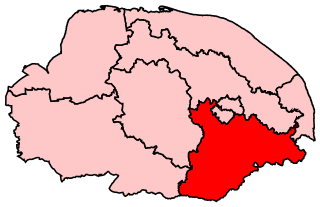
South Norfolk is a constituency represented in the House of Commons of the UK Parliament since 2001 by Richard Bacon, a Conservative.

The Jarrold Group is a Norwich–based company, founded as Jarrold & Sons Ltd, in 1770, by John Jarrold, at Woodbridge, Suffolk, before relocating to Norfolk in 1823. The Jarrold Group still involves members of the Jarrold family.

Attlebridge is a village and civil parish in the English county of Norfolk. It is situated about 8 miles (13 km) north-west of Norwich, where the A1067 crosses the River Wensum.

Bawdeswell is a small rural village and civil parish in Norfolk, England. At the time of the 2011 census it had a population of 828 and an area of 487 hectares. The village is situated almost in the centre of Norfolk about 14 miles (23 km) northwest of Norwich. For the purposes of local government it falls within the Upper Wensum Ward of Breckland District Council and the Elmham and Mattishall Division of Norfolk County Council. It is on a Roman road that ran east–west between Durobrivae near modern Peterborough and Smallburgh, crossing the Fen Causeway.

Eccles Road railway station is on the Breckland line in the east of England, serving the villages of Eccles, Quidenham and Wilby in Norfolk. The line runs between Cambridge in the west and Norwich in the east.

Sparham is a village and civil parish in Norfolk, England. It covers an area of 7.22 km2 (2.79 sq mi) and had a population of 291 in 109 households at the 2001 census, including Bylaugh and increasing to a population of 341 in 143 households at the 2011 census. For the purposes of local government, it falls within the Upper Wensum Ward of Breckland District Council and the Elmham and Mattishall Division of Norfolk County Council.

Twyford is a hamlet and civil parish in the English county of Norfolk. It is situated on the A1067 road, some 12 km (7.5 mi) south-east of the town of Fakenham and 28 km (17 mi) north-west of the city of Norwich.
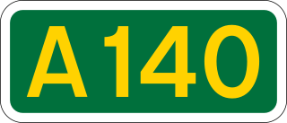
The A140 is an 'A-class' road in Norfolk and Suffolk, East Anglia, England partly following the route of the Roman Pye Road. It runs from the A14 near Needham Market to the A149 south of Cromer. It is of primary status for the entirety of its route. It is approximately 56 miles (90 km) in length.

The A1065 is a main road in the English region of East Anglia. It provides the principal road connection to parts of the west and north of the county of Norfolk from Newmarket and points south of there, including London. It runs from a junction near Mildenhall, to a junction on the western outskirt of Fakenham.
Foxley is a village and civil parish in Norfolk, England. The village is 6 miles (10 km) north-east of Dereham and 15 miles (24 km) north-west of Norwich, along the A1067 between Fakenham and Norwich.
In traffic engineering, saturation describes the maximum traffic flow which can be handled by a junction. The saturation flow is the rate at which a continuous flow of vehicles can pass through a constant green signal, typically expressed in vehicles per hour or PCUs per hour.
The B1145 runs for about 52 miles (84 km) through the county of Norfolk, England, between King’s Lynn and Mundesley. The road is an alternative route to the A47 between King's Lynn and Norwich by way of the A1067 from Bawdeswell onwards.
The Norwich Northern Distributor Road, now officially named the Broadland Northway is a 12.4 mi (20.0 km) dual-carriageway linking the A47 to the south east of the city to the proposed Rackheath Eco-town and Norwich International Airport to the north of Norwich before finishing at the A1067 Fakenham Road to the north west of the city. The road is designated the A1270, and in Spring 2018 was named the Broadland Northway.
Riverside is an area in the city of Norwich in the English county of Norfolk along the east bank of the River Wensum. Very close to the Central Business District, it lies between the river and the Great Eastern Main Line, with Norwich station at the northern end and Norwich City's Carrow Road stadium at the southern end.

Sweetbriar Road Meadows is a 9.7-hectare (24-acre) biological Site of Special Scientific Interest in Norwich in Norfolk.
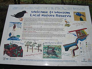
Wensum Local Nature Reserve or Wensum Valley is a Local Nature Reserve in Norwich in the English county of Norfolk. The reserve consists of two sites; Mile Cross Marsh52.6419°N 1.2657°E and Sycamore Crescent Wood which are linked by the Riverside Path a public footpath via the Sycamore Crescent footbridge

Foxley Wood is a nature reserve in Foxley, Norfolk, England, the largest ancient woodland and coppice in Norfolk. The Norfolk Wildlife Trust, which manages this reserve, bought it in 1998. It is 123 hectares in size. It is a Site of Special Scientific Interest, a Nature Conservation Review site, Grade 2, and a National Nature Reserve.